1) GPS MAPS: Garmin GPS Units Compatibility with MAC Computers
Attention MAC users: Some Garmin GPS units have an Android Operating System, and cannot be accessed on a MAC computer.
(Note: the unit is accessible on a Windows PC).

If you are purchasing Downloadable GPS Maps from us, you will need an SD Card. Complete instructions are sent upon purchase.
You will need to write an image file (.img) to an SD Card, which will then be inserted into the Garmin GPS unit. (ie. This will be done via an SD Card reader/writer or via an adaptor slot in your MAC if there is one).
The minimum SD card recommended size = 4GB.

For more information on which Garmin GPS units are not compatible with MAC computers see here.
2) Videos: MapSource Basics FULL Tutorial – A detailed tutorial on basics of MapSource & Tracks4africa Maps
3) Garmin Tread XL – Overland Edition Functionality
Tread XL Overland Findings:
- Works with plug and play SD card.
- Is picked up by MapInstall/BaseCamp/Express
- Route and POI transfer from BaseCamp works per usual. Just on the Garmin have to import waypoints and routes to “trip planner” and “waypoints” from gpx, which it picks up automatically. NOT THROUGH GARMIN EXPLORE. It does not have it. It works the same manner as the Zumo models.
- It has a track recorder App similar to the Overlander, which you turn On/Off. Weare assuming that transferring tracks from the Tread to BaseCamp wil work the same as above, just opposite.
ONLY EXCEPTION:
When you plug the tread into the PC (without an SD Card Inserted) it picks up two separate drives inside the Tread.
This causes MapInstall to pick up the storage as (Internal Storage + SD Card) even though there is no SD card inserted. There is no choice presented to choose between the two drives in drop-down box, similar to the Montana connection in MapInstall.
If you then send a map set to the Tread via MapInstall, it sends the maps to a “Map” folder on the second drive.
Then, if the tread is switched on, the maps don’t appear in “MyMaps”.
However, if you the copy and paste this image file into the “Map” folder of the first Drive via the PC, then it is picked up in “MyMaps” on the Tread.
APPLE MAC & the Tread: Does not recognise this device, it will not be picked up by Apple - as it is an android based device.4) GPS MAPS: maps.me and google maps compatibility
Neither Google nor Maps.me allows for other maps to be loaded to it. These apps only run with their own maps.5) GPS MAPS: Windows XP requires older versions of Basecamp
Sometimes a customer has an older version of Windows (ie. Windows XP) and then it doesn't work with the newer version of Garmin Basecamp/Mapsoure - in which case the customer needs to install an older version of Basecamp/Mapsource:Customers might sometimes also require a T4A Map with the older installation file of the current version. Please request this to sales@tracks4africa.co.za6) GPS MAPS: SD Card Size for T4A Maps & Formatting
If you purchased our downloadable GPS maps, and want to transfer it to your GPS unit onto an SD Card, you can either purchase an SD Card or overwrite your old T4A GPS Maps sd card if you have one:- Recommended size:
- You could get away with a 2Gb card but maybe 4Gb is safer if you want to load additional files such as our GPS Africa Guide.
- Formatting an SD Card:
- It must be formatted to FAT or FAT32. Either will work, but the recommended option FAT32.
- Recommended size:
7) GPS MAPS: Routing Problems
*Please note: all reference here is made using Basecamp. You can try this with Mapsource too – although Mapsource does not transfer the T4A GPS maps version 18.10 and later properly to a GPS unit. We therefore recommend Basecamp for transferring routes to a GPS unit. Firstly, about transferring routes: we do not advise our clients to do this. The transfer of routes between Garmin's Basecamp and GPS is a dark science which yields different results based on which units are used. It has nothing to do with the maps loaded. However if you are going to try and do this then note the following: Sometimes customers report various routing problems:- Basecamp is calculates routes incorrectly, or routes and times are wrong
- Routes and times are incorrect on a GPS unit
- Basecamp and your Garmin GPS must have the exact same maps loaded, i.e. the map you used for calculating the route in the first place must also be on the GPS
- Uninstall all versions of T4A from your Garmin and BaseCamp. The old and new versions respectively.
- Then do a fresh install on BaseCamp of your T4A GPS Maps.
- Then recalculate the routes on BaseCamp and then send them to your Garmin GPS.
- The GPS will always recalculate the route once loaded (on some units you have to import the route after transferring it). For this reason the route calculation settings on the GPS and your Basecamp software must also be exactly the same else you will get different results. E.g. if you use Shortest Distance on Basecamp then GPS must also be set to Shortest Distance (these settings are not transferred to the GPS)
- In some cases it simply does not work.
- If you succeed in transferring a route and you select this route then your GPS will now try to get you to the start of the route. If your starting point is different from what you calculated on the GPS you will have to recalculate the route from your current location.
- In Basecamp, under your activity profile, check if any of your "avoidances" are ticked? We do not have Interstate or State Highways in Africa, and if those are ticked, it causes problems when trying to do routing in Basecamp. The best is to untick all of them - go to your activity profile and click on the arrow, right at the bottom you can "edit activity profile" and the options box (screenshot below) will open up. Select activity profile and then go to routing, to see which avoidances are switched on. Note that if you have one profile for driving, one for motorbike, and one for hiking, you will need to untick it for each activity profile.
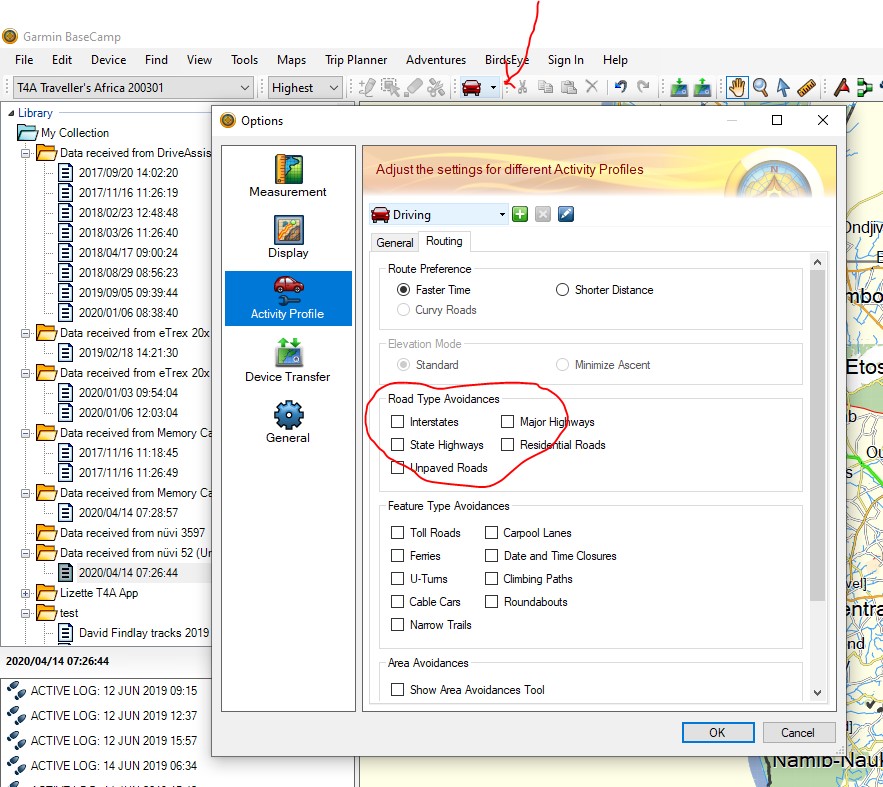
- If you do have avoidances ticked, please untick them and click on OK - now try the same route again, and see if the map still re-routes you on a detour for no reason.
- Sometimes we have tracks in a concession area, where one may only travel with a guide, e.g. the northern section of the Skeleton Coast in Namibia. So we have the tracks in the map, so you can still do planning for this area if you want, but we put a break in our roads, so you cannot navigate directly into this area. There is usually also a waypoint here that says "permit required" or "no entry north without guide".
8) GPS MAPS: IMG file installation for the Garmin Overlander
T4A Garmin Image File Installation for the Garmin Overlander
- Insert SD Card into Adapter into a computer
- Format the SD Card. Verify File System is FAT or FAT32
- Create a folder with the name “Map” on the SD Card
- Copy the T4A Traveller's Africa ######.img file into the Map folder
- Remove the SD Card from the computer and insert it onto the Overlander
- Restart the Overlander
- Navigate to “My Maps” in the “Settings” menu
- Make sure the T4A Map displays in the list of maps and that it is checked as active
- Deactivate all other City Navigator Maps (CN) for Africa. You can leave the DEM Maps active
- Tracks4Africa data should now be active and visible when viewing the map
9) GPS MAPS: Corrupt SD Card
If your Garmin GPS unit gives an error to say that the "SD Card is corrupt".... There could be various reasons for this, and it does not necessarily mean that there is something wrong with the T4A SD Card. Please try the following solutions: • Reboot your GPS unit to clear the error • If that fails, connect your GPS unit via a USB cable to your PC – copy and paste the contents of the SD Card to your PC; then format the SD Card; then copy and paste the files from your SD card back onto your SD Card. • If that fails, please update your Garmin via Garmin Express which keeps your device up to date from Garmin.10) GPS MAPS: BMW Motorad Navigator 5
Is compatible with the T4A GPS Maps. How to insert the T4A GPS Maps SD Card:The BMW Navigator 5 has an SD Card slot, you will have to open at the back of the device and remove the battery to see the SD Card slot, also on the back of the device, there is another "flap" on the back of the device too which you can open (or lift rather), to connect the USB Cable that you would have received when you purchased the GPS.