CLICK ON THE FAQ’S BELOW TO VIEW THE ANSWERS:
1) GPS MAPS: Routing Problems
*Please note: all reference here is made using Basecamp. You can try this with Mapsource too – although Mapsource does not transfer the T4A GPS maps version 18.10 and later properly to a GPS unit. We therefore recommend Basecamp for transferring routes to a GPS unit.
Firstly, about transferring routes: we do not advise our clients to do this. The transfer of routes between Garmin's Basecamp and GPS is a dark science which yields different results based on which units are used. It has nothing to do with the maps loaded.
However if you are going to try and do this then note the following:
Sometimes customers report various routing problems:
- Basecamp is calculates routes incorrectly, or routes and times are wrong
- Routes and times are incorrect on a GPS unit
For problem-solving please try this:
- Basecamp and your Garmin GPS must have the exact same maps loaded, i.e. the map you used for calculating the route in the first place must also be on the GPS
- Uninstall all versions of T4A from your Garmin and BaseCamp. The old and new versions respectively.
- Then do a fresh install on BaseCamp of your T4A GPS Maps.
- Then recalculate the routes on BaseCamp and then send them to your Garmin GPS.
- The GPS will always recalculate the route once loaded (on some units you have to import the route after transferring it). For this reason the route calculation settings on the GPS and your Basecamp software must also be exactly the same else you will get different results. E.g. if you use Shortest Distance on Basecamp then GPS must also be set to Shortest Distance (these settings are not transferred to the GPS)
- In some cases it simply does not work.
- If you succeed in transferring a route and you select this route then your GPS will now try to get you to the start of the route. If your starting point is different from what you calculated on the GPS you will have to recalculate the route from your current location.
If the problem is more that you cannot create a route in Basecamp between 2 point because of possible “breaks” in a track:
- In Basecamp, under your activity profile, check if any of your "avoidances" are ticked? We do not have Interstate or State Highways in Africa, and if those are ticked, it causes problems when trying to do routing in Basecamp. The best is to untick all of them - go to your activity profile and click on the arrow, right at the bottom you can "edit activity profile" and the options box (screenshot below) will open up. Select activity profile and then go to routing, to see which avoidances are switched on. Note that if you have one profile for driving, one for motorbike, and one for hiking, you will need to untick it for each activity profile.
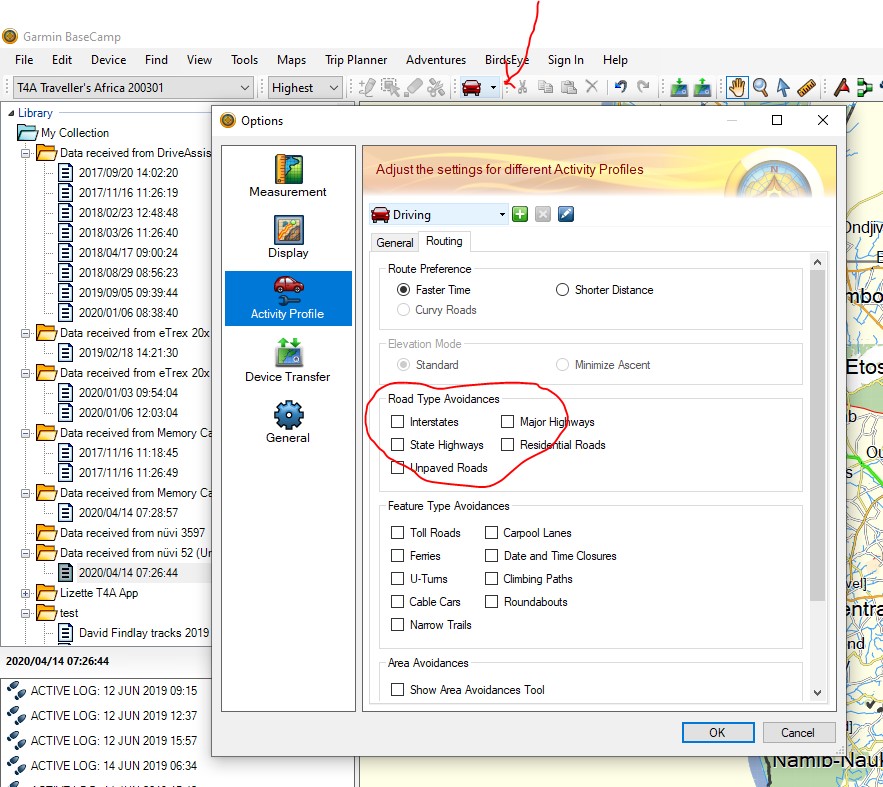
- If you do have avoidances ticked, please untick them and click on OK - now try the same route again, and see if the map still re-routes you on a detour for no reason.
- Sometimes we have tracks in a concession area, where one may only travel with a guide, e.g. the northern section of the Skeleton Coast in Namibia. So we have the tracks in the map, so you can still do planning for this area if you want, but we put a break in our roads, so you cannot navigate directly into this area. There is usually also a waypoint here that says "permit required" or "no entry north without guide".
Best practise:
We normally advise people to calculate their routes on Basecamp in order to do their trip planning. Then on the GPS on the day of your travel find the destination and let it calculate the route from where you are to that destination. You may want to print your itinerary or even send some crucial waypoints/POIs from your trip plan to your GPS which is then stored under Favourites for easy access, as waypoints/POIs to route to on your GPS.