Complete Garmin GPS Mapset Download v24.12 – 1 Year Map Updates

(122 customer reviews)

R1,250.00 for 1 year

for Compatible Garmin GPS Systems only! (Click here to check)

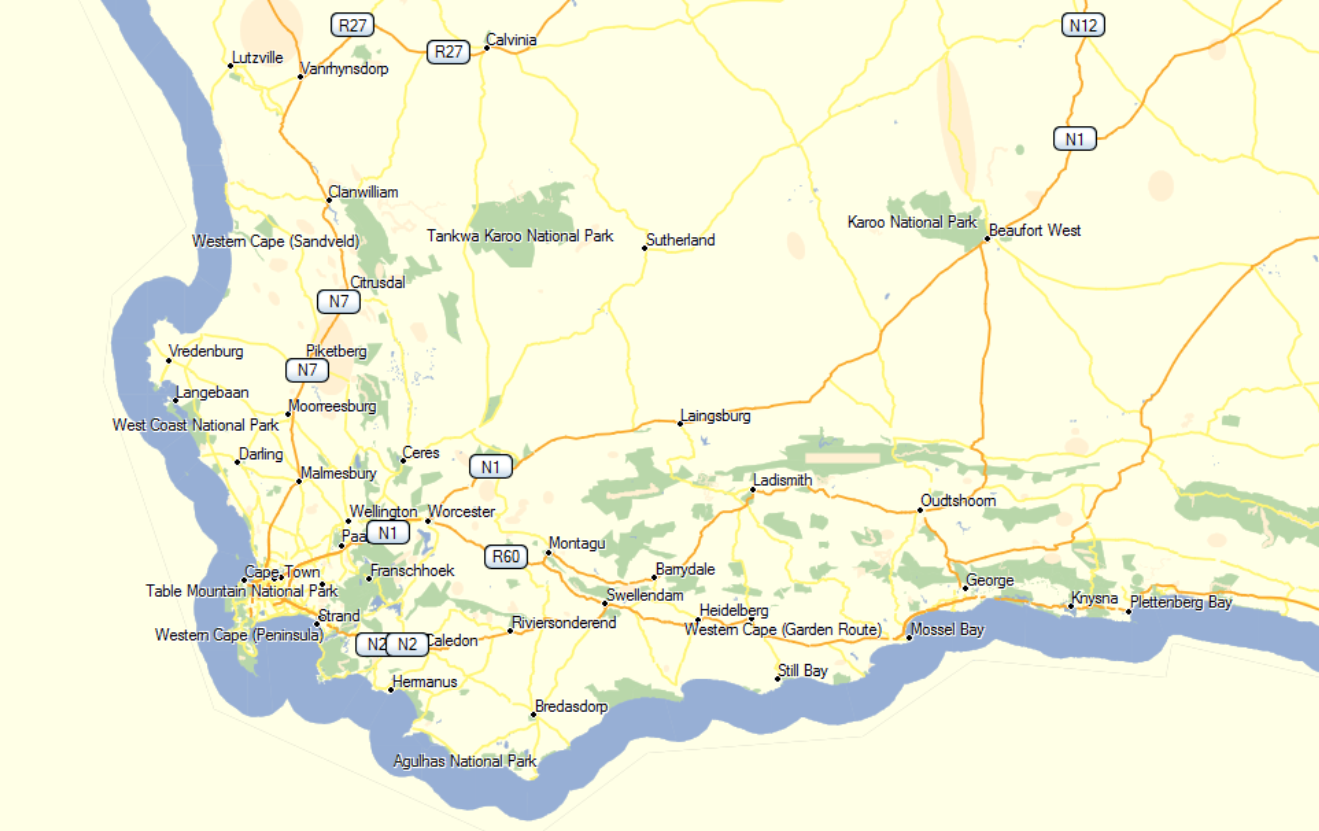
T4A GPS maps cover the entire African continent, providing the most detailed coverage to tourists across Southern and Eastern Africa. Our uniquely African GPS maps are routable in most parts of Africa and can in fact give you turn-by-turn directions from Cape to Cairo.

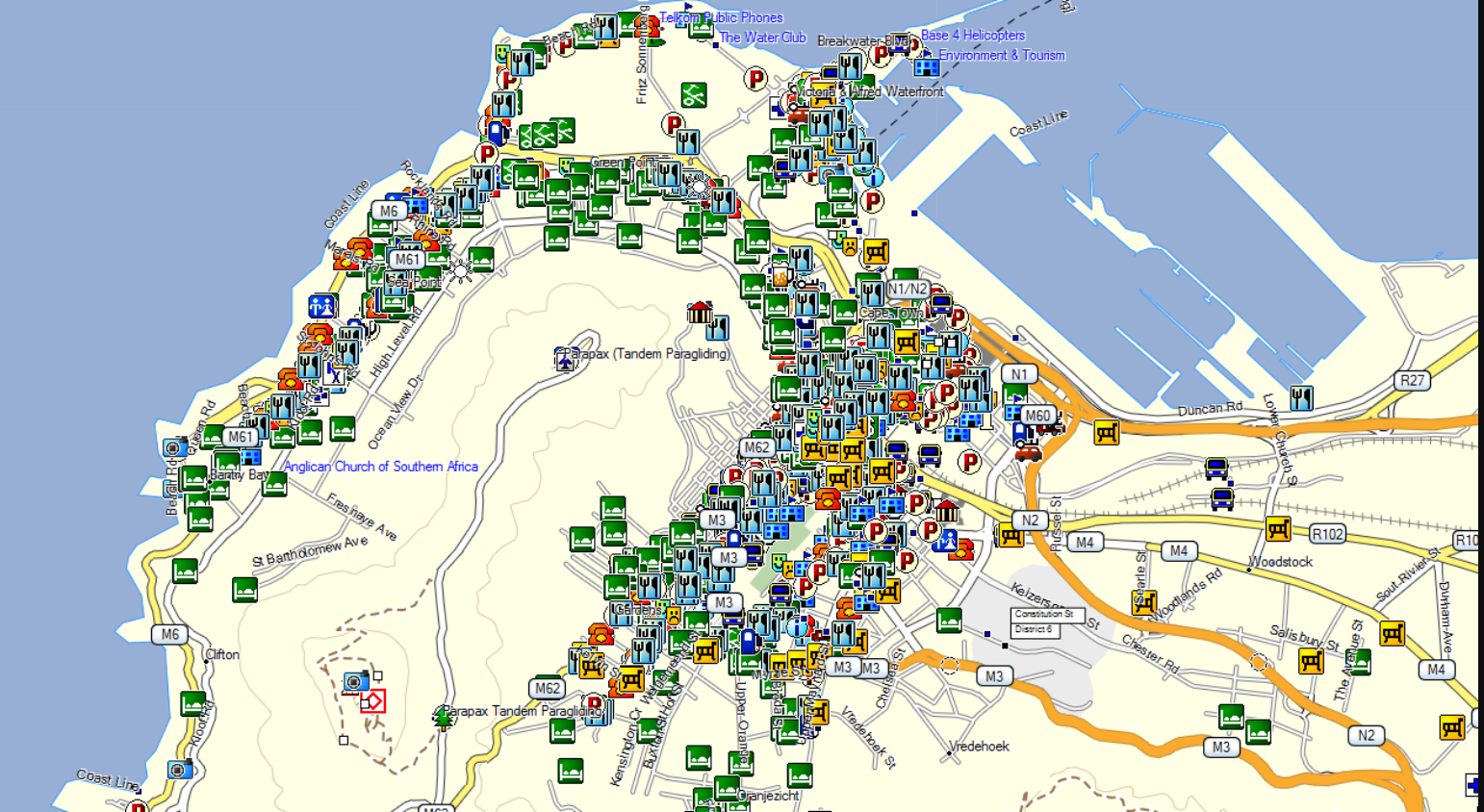
We have an incredibly rich set of points of interest which is absolutely relevant to the independent traveller in Africa, ranging from activities, attractions to fuel stops and emergency services. We have accommodation such as hotels, guest lodges, backpackers as well as the most comprehensive listing of campsites in Africa.

If you subscribe to this complete set, you will be entitled to:

  • All the map updates we release within the next 12 months (ie. Our upgrades are 01 March, 01 June, 01 September and 01 December) (eg. ver 24.03, 24.06, 24.09, 24.12) *Note: in 2024 we released an updated version of the 24.09, which is now 24.10
  • Your maps will never expire and will continue working after the 12 months.
  •  Any future purchase of the complete set/GPS Maps on SD Card of subsequent version releases, will then be at a 50% discount regardless of when you come back to buy.
  • For more info on our Downloadable GPS Maps Upgrade Subscription Policy – please read here.

What’s new on our latest version?

Please visit our FAQ Page for more information on our GPS Maps.

Attention MAC users: Some Garmin GPS units have an Android Operating System, and it will not appear as a drive on the desktop and the device’s internal files cannot be accessed (eg. Certain DriveSmarts, Overlander, Tread Series, Zumo XT). 
It will mean that you will have to purchase an SD Card to transfer the downloadable map to. Complete instructions are sent upon purchase. The minimum SD card recommended size = 4GB.

Garmin GPS units with an Android Operating System.

Cancellation and Returns Policy.

Product Description

Prerequisites: This map is compatible with Garmin map capable GPS units only.

T4A GPS Maps are a set of 16 regional GPS maps covering most parts of the African continent. If you are a tourist or business traveller and looking for a GPS map to guide you through Africa then you would appreciate the accuracy and detail of T4A GPS Maps.

Our maps are constructed from GPS data sourced from the T4A Community of travellers. People just like you who record their travel experience and share it with the community via our maps. Do not expect complete wall to wall coverage from our maps. We only map places that are relevant to travellers and we endeavour to construct the safest routable GPS maps in Africa.

T4A GPS Maps will take you to the most incredible places on the African continent and we boast a very comprehensive set of tourist destinations. Be it the Ngorongoro Crater or Gorilla trekking in Rwanda or simply a very good restaurant in Cape Town you are after, we have them mapped.

Software Required: In order to view this map on your computer, to perform route planning and to transfer the maps to your Garmin GPS unit, you will need free Software from Garmin, which can be downloaded from Garmins’ website:

  • For Windows: Mapinstall. Then Basecamp or Mapsource too.
  • For MAC: Mapinstall. Then Basecamp too.


Find all technical info and detailed steps in our user-friendly T4A User Guides and Videos see here.

Please visit our FAQ Page for more information on our GPS Maps.

If you have subscribed to the complete set of our GPS Downloadable Maps, please contact us to receive our Africa Guide file, and info guide loaded onto your GPS, which contains valuable information like contact details etc. for campsites, lodging, attractions, activities, where to find picnic sites etc. It can be easily transferred from your PC to your Garmin GPS Unit. Please make sure that you have a good internet connection to download the guide from us.

Did you know that you can get this complete set of maps on SD Card too? Plug ‘n play! See here for more info!


T4A GPS Maps Explained – watch this video:


Please consider submitting your travel data to us. See here for more information.

General

GPS Maps for Garmin

  • 1) GPS MAPS: BASECAMP VER 4.7.0.0 MAPS TRANSFERRED TO GPS ARE NOT SHOWING ON THE GPS (WINDOWS ONLY)

     The problem lies in Basecamp.

    We have advised Garmin of this issue.

    Temporary Solutions:

    If you have an older GPS unit (ie. Mapsource is only compatible with older units) – Click here to download a free version of Mapsource and to use that instead of BaseCamp. Your problem should then be resolved

    OR

    Contact our sales staff for assistance.

    Our sales staff will then send you a temporary download link, containing an .img file which you will have to install on your Garmin unit.

    Please follow these steps once you have received the download link email / download link:

    Please download this file in the email you will receive from Tracks4Africa. You will be directed to a downloads webpage where you will find the .img file to download unless you have been emailed the .img file directly you don’t have to access it from a downloads page then.

    It is advisable to access the webpage on the internet, via a Google Chrome or Firefox browser for best results. (ie. do not try to open the downloaded file or run it on your PC – its an .img file for a GPS Unit).

    Then connect your Garmin GPS unit to your PC.

    Then in Windows Explorer, or from a relevant spot in your PC, you need to copy this .img file to either: (Please note different GPS units are behaving differently):

    • an SD Card in your GPS unit directly into a Garmin folder. If that does not work, try to copy the .img file to a Map folder (ie. create this folder on your SD card if there is no such folder yet)
    • or your GPS units’ internal memory – to a Garmin folder. If that does not work try to copy the .img file to a Map folder (ie. create this folder on your GPS units internal memory if there is no such folder yet)

    Also, please note:If there are any older Tracks4Africa GPS Map files in your Garmin folder, please copy all these old files to your PC in a safe folder, and then remove them from the Garmin folder on your GPS Unit. Be careful not to remove your Garmaps and their associated license (.lic) files from your GPS units internal memory.

    Your GPS Maps will then be visible on your GPS Unit.

    Troubleshooting:If you loaded the .img file to your GPS units internal memory, and it didn’t work, please remove it from there and try loading it to a GARMIN/MAP folder on your SD Card instead, and vice versa following the instructions as per above.


  • 2) VIDEOS: BaseCamp Basics Full Tutorial – A detailed tutorial on basics of BaseCamp & Tracks4africa Maps

  • 3) USER GUIDES & VIDEOS: For Garmin GPS Maps

  • 4) GPS MAPS: Polnav Navigator

    Our Garmin SD cards will not work on this device.

    We manufacture a T4A SD card which runs on WinCE and supply this to Planet Electronics. It could be that this may work however we cannot say for sure as we do not create cards specifically for the device you have. The manufacturer or dealer should be able to assist you with this.
    We do not sell the WinCE cards ourselves but you can contact Planet Electronics.
  • 5) GPS Maps: Basecamp lagging on a MAC

    If you find that Basecamp is running very slowsly on your MAC, and that it is slow to react when you pan or zoom on it:

    We advise that you uninstall Basecamp.

    Then update your OS (Operating System) on your MAC.

    Then reinstall Basecamp.

    This may resolve your issue.

  • 6) GPS MAPS: BMW Motorad Navigator 5

    Is compatible with the T4A GPS Maps.

    How to insert the T4A GPS Maps SD Card:

    The BMW Navigator 5 has an  SD Card slot, you will have to open at the back of the  device and remove the battery to see the SD Card slot, also on the back of the device, there is another “flap” on the back of the device too which you can open (or lift rather), to connect the USB Cable that you would have received when you purchased the GPS.
  • 7) GPS MAPS: maps.me and google maps compatibility

    Neither Google nor Maps.me allows for other maps to be loaded to it.  These apps only run with their own maps.

  • 8) Videos: MapSource Basics FULL Tutorial – A detailed tutorial on basics of MapSource & Tracks4africa Maps

  • 9) GPS MAPS: The Garmin Overlander on Tracks4Africa

    We have tested the Overlander and here are our basic findings:
    • It only communicates to a Windows computer, not Mac.
    • It is possible to connect it to Basecamp on a Windows computer and we could load our maps to it and it is compatible.
    • Our SD Card version from 19.10 will work with the Overlander.  We realised that this unit and some other newer Garmin models require the folder structure on the Sd card to be slightly different and it was easy enough to include this change.
    • We could not find a way to load and copy tracks from the Overlander without having to use the Explorer app though. So that is a bit of an oversight on their side as this unit is made to use in remote areas without the implicit need for internet access.
    • The bracket the Overlander comes with does not hold up to off road travel for long.  Our unit was in fact shipped with a RAM ball adapter and I would strongly recommend doing this conversion and mounting the unit with RAM fittings and suction cups.
  • 10) GPS MAPS: Corrupt SD Card

    If your Garmin GPS unit gives an error to say that the “SD Card is corrupt”….

    There could be various reasons for this, and it does not necessarily mean that there is something wrong with the T4A SD Card.
    Please try the following solutions:
    • Reboot your GPS unit to clear the error
    • If that fails, connect your GPS unit via a USB cable to your PC – copy and paste the contents of the SD Card to your PC; then format the SD Card; then copy and paste the files from your SD card back onto your SD Card.
    • If that fails, please update your Garmin via Garmin Express which keeps your device up to date from Garmin.

  • 11) GPS MAPS: IMG file installation for the Garmin Overlander

    T4A Garmin Image File Installation for the Garmin Overlander

    1. Insert SD Card into Adapter into a computer
    2. Format the SD Card. Verify File System is FAT or FAT32
    3. Create a folder with the name “Map” on the SD Card
    4. Copy the T4A Traveller’s Africa ######.img file into the Map folder
    5. Remove the SD Card from the computer and insert it onto the Overlander
    6. Restart the Overlander
    7. Navigate to “My Maps” in the “Settings” menu
    8. Make sure the T4A Map displays in the list of maps and that it is checked as active
    9. Deactivate all other City Navigator Maps (CN) for Africa. You can leave the DEM Maps active
    10. Tracks4Africa data should now be active and visible when viewing the map
  • 12) GPS MAPS: SD Card Size for T4A Maps & Formatting

    If you purchased our downloadable GPS maps, and want to transfer it to your GPS unit onto an SD Card, you can either purchase an SD Card or overwrite your old T4A GPS Maps sd card if you have one:

    • Recommended size:
      • You could get away with a 2Gb card but maybe 4Gb is safer if you want to load additional files such as our GPS Africa Guide.


    • Formatting an SD Card:
      • It must be formatted to FAT or FAT32. Either will work, but the recommended option FAT32.
  • 13) GPS MAPS: Routing Problems

    *Please note: all reference here is made using Basecamp. You can try this with Mapsource too – although Mapsource does not transfer the T4A GPS maps version 18.10 and later properly to a GPS unit. We therefore recommend Basecamp for transferring routes to a GPS unit.


    Firstly, about transferring routes: we do not advise our clients to do this. The transfer of routes between Garmin’s Basecamp and GPS is a dark science which yields different results based on which units are used.  It has nothing to do with the maps loaded.


    However if you are going to try and do this then note the following:

    Sometimes customers report various routing problems:

    • Basecamp is calculates routes incorrectly, or routes and times are wrong
    • Routes and times are incorrect on a GPS unit


    For problem-solving please try this:

    • Basecamp and your Garmin GPS must have the exact same maps loaded, i.e. the map you used for calculating the route in the first place must also be on the GPS
    • Uninstall all versions of T4A from your Garmin and BaseCamp. The old and new versions respectively.
    • Then do a fresh install on BaseCamp of your T4A GPS Maps.
    • Then recalculate the routes on BaseCamp and then send them to your Garmin GPS.
    • The GPS will always recalculate the route once loaded (on some units you have to import the route after transferring it).  For this reason the route calculation settings on the GPS and your Basecamp software must also be exactly the same else you will get different results.  E.g. if you use Shortest Distance on Basecamp then GPS must also be set to Shortest Distance (these settings are not transferred to the GPS)
      • In some cases it simply does not work.
    • If you succeed in transferring a route and you select this route then your GPS will now try to get you to the start of the route. If your starting point is different from what you calculated on the GPS you will have to recalculate the route from your current location.

    If the problem is more that you cannot create a route in Basecamp between 2 point because of possible “breaks” in a track:

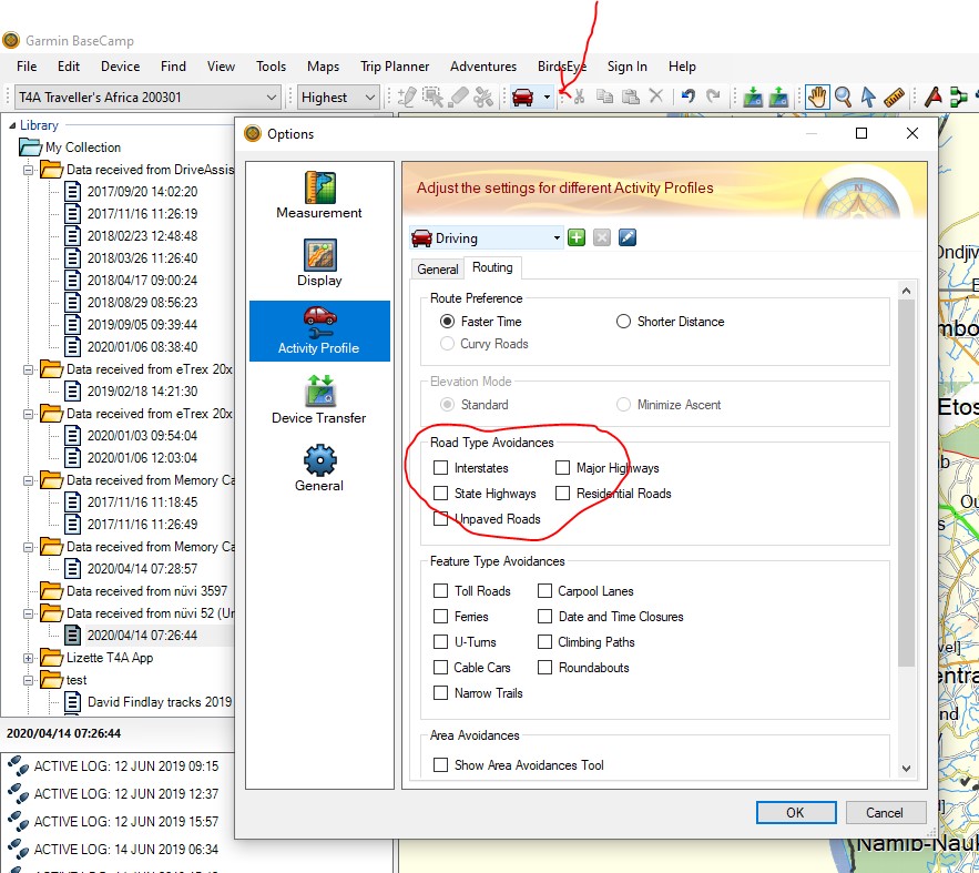
    • In Basecamp, under your activity profile, check if any of your “avoidances” are ticked? We do not have Interstate or State Highways in Africa, and if those are ticked, it causes problems when trying to do routing in Basecamp. The best is to untick all of them – go to your activity profile and click on the arrow, right at the bottom  you can “edit activity profile” and the options box (screenshot below) will open up. Select activity profile and then go to routing, to see which avoidances are switched on. Note that if you have one profile for driving, one for motorbike, and one for hiking, you will need to untick it for each activity profile.

    • If you do have avoidances ticked, please untick them and click on OK – now try the same route again, and see if the map still re-routes you on a detour for no reason.
    • Sometimes we have tracks in a concession area, where one may only travel with a guide, e.g. the northern section of the Skeleton Coast in Namibia. So we have the tracks in the map, so you can still do planning for this area if you want, but we put a break in our roads, so you cannot navigate directly into this area. There is usually also a waypoint here that says “permit required” or “no entry north without guide”.

    Best practise:

    We normally advise people to calculate their routes on Basecamp in order to do their trip planning.  Then on the GPS on the day of your travel find the destination and let it calculate the route from where you are to that destination. You may want to print your itinerary or even send some crucial waypoints/POIs from your trip plan to your GPS which is then stored under Favourites for easy access, as waypoints/POIs to route to on your GPS.


  • 14) GPS MAPS: Windows XP requires older versions of Basecamp

    Sometimes a customer has an older version of Windows (ie. Windows XP)  and then it doesn’t work with the newer version of Garmin Basecamp/Mapsoure – in which case the customer needs to install an older version of Basecamp/Mapsource:
    Customers might sometimes also require a T4A Map with the older installation file of the current version. Please request this to sales@tracks4africa.co.za
  • 15) Garmin Tread XL – Overland Edition Functionality

    Tread XL Overland Findings:

    1. Works with plug and play SD card.
    2. Is picked up by MapInstall/BaseCamp/Express
    3. Route and POI transfer from BaseCamp works per usual. Just on the Garmin have to import waypoints and routes to “trip planner” and “waypoints” from gpx, which it picks up automatically. NOT THROUGH GARMIN EXPLORE. It does not have it. It works the same manner as the Zumo models.
    4. It has a track recorder App similar to the Overlander, which you turn On/Off. Weare assuming that transferring tracks from the Tread to BaseCamp wil work the same as above, just opposite.

    ONLY EXCEPTION:

    When you plug the tread into the PC (without an SD Card Inserted) it picks up two separate drives inside the Tread.

    This causes MapInstall to pick up the storage as (Internal Storage + SD Card) even though there is no SD card inserted. There is no choice presented to choose between the two drives in drop-down box, similar to the Montana connection in MapInstall.

    If you then send a map set to the Tread via MapInstall, it sends the maps to a “Map” folder on the second drive.

    Then, if the tread is switched on, the maps don’t appear in “MyMaps”.

    However, if you the copy and paste this image file into the “Map” folder of the first Drive via the PC, then it is picked up in “MyMaps” on the Tread.

    APPLE MAC & the Tread:

    Does not recognise this device, it will not be picked up by Apple – as it is an android based device.

  • 16) GPS MAPS: Garmin GPS Units Compatibility with MAC Computers

    Attention MAC users: Some Garmin GPS units have an Android Operating System, and cannot be accessed on a MAC computer.
    (Note: the unit is accessible on a Windows PC).
    
    If you are purchasing Downloadable GPS Maps from us, you will need an SD Card. Complete instructions are sent upon purchase.  
    You will need to write an image file (.img) to an SD Card, which will then be inserted into the Garmin GPS unit. (ie. This will be done via an SD Card reader/writer or via an adaptor slot in your MAC if there is one). 
    The minimum SD card recommended size = 4GB.
    
    For more information on which Garmin GPS units are not compatible with MAC computers see here.
    
    
  • 17) VIDEOS: A guide to installing MapInstall on your Mac computer

  • 18) VIDEOS: Install T4A Maps on Windows From a (Digital Download Link)

  • 19) VIDEOS: Install T4A GPS Maps on Mac (From Digital Download)

  • 20) VIDEOS: Installing Tracks4Africa GPS Maps on your Windows PC from an SD Card

  • 21) VIDEOS: Installing Tracks4Africa GPS Maps on your Mac Computer from an SD Card

  • 22) GPS MAPS: Removing T4A POI clutter on Garmin Maps

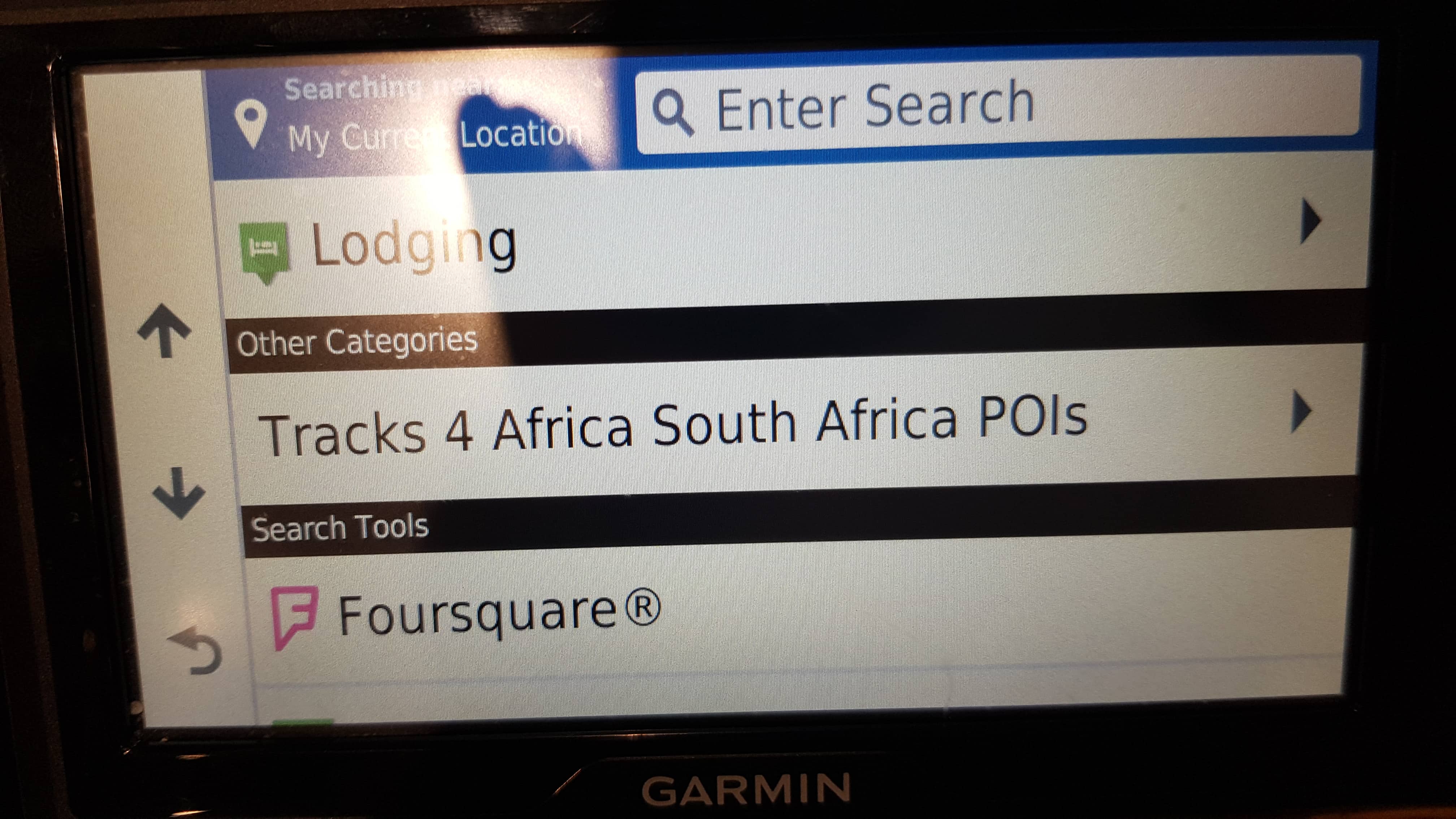
    Garmin, for some or other reason, has included a random T4A POI layer on their units as follows for example: 


    This is creating an annoyance on Garmin users devices, as POI around them pop up all over the place on their screen represented by white T4A number 4’s.

    You can follow the steps below in order to remove this.

    Please note that T4A has never requested Garmin to incorporate our POIs into their maps and device in this manner. We are reported the issue to Garmin and they have removed it in their latest units: To solve for now:

    Step 1: Connect your device to your computer using the USB cable the device came with.

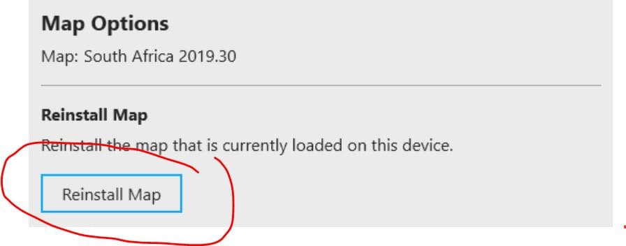
    Step 2: Open Garmin Express, navigate to your device, once you have selected your device in Garmin express, please select “Map options” (indicated in screen shot below)

    Step 3: Select “Reinstall map” followed by “Continue”.


    Step 4: Allow the reinstallation of the map to complete, this will load the corrected files onto your device which will solve the clutter of the Tracks4Africa Pois on the map screen when navigating.

  • 23) VIDEOS: Installing T4A GPS Maps – Windows

  • 24) VIDEOS: Installing T4A GPS Maps – Mac

  • 25) GPS MAPS: I cannot install Mapsource

    If you downloaded the free link from Garmin to install Mapsource – and it gave an error during the installation informing you that you have to have another Garmin software product installed on your computer in order to complete the Mapsource installation, you can try to install MapInstall first, and then try to install Mapsource again:

    Click here for the download link to MapSource in order to install it:


  • 26) VIDEOS: A guide to installing BaseCamp on your Windows computer

  • 27) VIDEOS: A guide to installing BaseCamp on your Mac computer

  • 28) GPS MAPS: HOW DO I ENABLE MY T4A GPS MAPS ON MY GARMIN GPS DEVICE?

    Depending on what GPS unit you have, it will differ from GPS range to GPS range. (i.e. the procedure you will follow on the Garmin Nuvi will differ from a Garmin Montana etc) Your installed GPS Maps will always be listed under your Map information which is located under your settings / tools option on the GPS.

    Steps on the newer Garmin Nuvi range: (Please note that the older Garmin Nuvi range will work differently to the newer units)

    Switch on your GPS and select Settings on the home page.


    Then select Map & Vehicle on the next page.

    On the next page, scroll down and select myMaps. All your installed GPS Maps will be listed here.

    Enable the map you wish to use on your GPS by selecting the tick box

    Remember that you may only have one map product enabled (ticked) otherwise the GPS won’t know which map to use and will give navigation errors.

    Steps on the Garmin Montana range:

    On the home page of the GPS, click on the arrow on the left-hand side of the screen.

    Select Setup on the next page

    Then select Map.

    Click on Map Information and then Select Map.

    Click on the map you wish to enable on your GPS device.

    Select Enable in order to have the GPS map of your choice enabled.

    Remember that you may only have one map product enabled otherwise the GPS will give navigation errors.


  • 29) GPS MAPS: Can I load my T4A Maps onto my Garmin Satellite Navigation System?

    To us a sat nav and GPS is the same thing.
    Our maps are compatible with any map-capable Garmin GPS.  Garmin will specify in the specifications section if a GPS is map-capable and if one can load additional maps, but this is true for almost all of them.
  • 30) GPS MAPS: Basecamp Export to Excel

    If you save your Basecamp/Mapsource file as a .gpx file (not .gdb),  you can open the .gpx file with excel. You are going to get a few warning messages before the final file will open:

    Click yes.

    Open as an xml.

    Click OK

    If you have tracks and routes in the same file, you will get another error message (you can only open waypoint locations, not tracks and routes)

    Click OK.

    You will now get a spreadsheet with a lot of columns.

  • 31) GPS MAPS: WHICH GPS UNITS ARE COMPATIBLE WITH TRACKS4AFRICA GPS MAPS?

    Our Tracks4Africa GPS maps are only compatible to Garmin GPS devices only.

    Requirements for your GPS to be compatible with our maps:

    • Must be able to read Garmin maps
    • Must be able to receive maps (a SD card slot is not a requirement)
    • Should be able to receive automotive maps from PC /Mac
    We also sell Garmin GPS units and accessories on our online shop – have a look here.

    Examples of Compatible Garmin Devices: (ie. please note there are many more compatible Garmin Devices, these are just a few examples. Some may be outdated. All new Garmin Devices should be compatible with Tracks4Africa Maps).

    • Garmin Aera Range:
      •  We have not been using this specific unit ourselves but that from what we can see it should work as the unit allows you to add maps and it has street navigation.
    • Garmin BMW Motorrad Navigator
    • Garmin Camper 760
    • Garmin Camper 780
    • Garmin Dezl 780LMT-D HGV 6.95″ Sat Nav
    • Garmin Drive 40 LMT
    • Garmin DriveAssist™ 51 LMT-S
    • Garmin DriveSmart™ 51 LMT-S
    • Garmin DriveSmart™ 50 LMT-D
    • Garmin DriveSmart™ 55MT-S
    • Garmin DriveSmart™ 55
    • Garmin DriveSmart™ 66
    • Garmin DriveSmart™ 76
    • Garmin DriveSmart™ 86
    • Garmin DriveSmart™ 65 LMT-S
    • Garmin Drive 52 LMT-S
    • Garmin Drive 60 LMT
    • Garmin Drive 61 LMT-S
    • Garmin Edge Touring
    • Garmin Edge 1000
    • Garmin eTrex 20 (is a good option, but the screen is a bit small)
    • Garmin eTrex 22x
    • Garmin eTrex 30 (is a good option, but the screen is a bit small)
    • Garmin eTrex 32x
    • Garmin Etrex Touch 25
    • Garmin Etrex Touch 35 (ie. The SD card slot is behind the batteries, inside the compartment)
    • Garmin Fenix 6X Pro Solar (This device has not been tested – we do think its possible to load our maps to it, but we are unsure if routing will work. You can request a test map from us to try it out)
    • Garmin Fenix 7x – Sapphire Solar Edition (This device has been tested – our maps can be loaded to it and routing also works)
    • Garmin GPSMap 64x
    • Garmin GPSMap 65s
    • Garmin GPSMap 66i
    • Garmin GPSMap 276Cx
    • Old Garmin GPSMap 276C (refer to also to FAQ ‘Using T4A GPS Maps on the Old Garmin GPSMap 276C’)
    • Garmin inReach Mini Orange
    • Garmin Monterra
    • Garmin NuviCam
    • GARMIN NuviCam LMTHD
    • Garmin Montana 600
    • Garmin Montana 650t
    • Garmin Montana 700
    • Garmin Montana 700i
    • Garmin Montana 750i
    • Garmin Colorado 300
    • Garmin Nüvi 40
    • Garmin Nüvi 40LM
    • Garmin Nüvi 42LM
    • Garmin Nüvi 50
    • Garmin Nüvi 200
    • Garmin Nüvi 205
    • Garmin Nüvi 205W
    • Garmin Nüvi 500
    • Garmin Nüvi 1300
    • Garmin Nüvi 2300
    • Garmin Nüvi 2595
    • Garmin Nüvi 2597
    • Garmin Nüvi 2789
    • Garmin Nüvi 3790
    • Garmin Nüvi 3760
    • Garmin Oregon 450
    • Garmin Oregon 750
    • Garmin Overlander (ie. Older SD cards may not show up but from our 19.10 version is definitely compatible; Note that Overlander only supports Windows and not MAC) 
    • Garmin Zumo 350
    • Garmin Zumo 396 LMT-S
    • Garmin Zumo 595
    • Garmin Zumo 660
    • Garmin Zumo XT

    Incompatible Garmin Devices:

    • Garmin Edge 820 (ie. If trying to load the T4A GPS Maps onto this device’s internal memory, the T4A GPS Map might wipe the Topo Map that is pre-loaded on the Garmin Edge 820).
    • Garmin eTrex 10 (ie. it cannot handle maps)
    • Garmin Forerunner 610 (ie. Garmin Forerunner 610 does not support any kind of mapping. It is a fitness device not intended for navigation).
    • Garmin Foretrex 401 (ie. it is not a map capable GPS, i.e. it does not have the ability to load maps).
    • Garmin GPSMAP® 60CSx (ie. The T4A GPS Maps on SD card will not work on this unit, as our SD cards are 4GIG, and this unit only accepts data cards of 64MB. Individual Mapsets purchased per region from our online shop will work, taken their sizes do not exceed 64MB. As at 2020 none of our regional maps exceeds 64MB. These maps are then opened in Mapsource/Basecamp (using MapInstall) on the customers PC, where they are then transferred to the connected GPS Device, to an SD Card of size 64MB).
    • Garmin inReach Explorer+  (ie. The inReach is actually a repurposed DeLorme unit bought by Garmin and rebranded, however they never changed the firmware to be compatible with Garmin maps, hence the reason our Garmin compatible maps will not work for this device).
    • Garmin Tread: it is not compatible with our routing.

    Garmin Devices Discontinued: (ie. Note that Garmin still provides support for these devices)

    • Garmin Drive 50LM (P/N: 010-01532-4B) and Drive 60LM (P/N: 010-01533-4B).
    • Garmin DriveAssist 50LMT (P/N: 010-01541-4A)
    • Garmin DashCam 35 (P/N: 010-01507-04)
    • Garmin DriveSmart 60LMT (P/N: 010-01540-4A)

    Other incompatible devices:

    • Polnav Navigator


    Tracks4Africa Blog articles for more information:

    CHOOSING A GPS FOR TRACKS4AFRICA MAPS


  • 32) GPS MAPS: What are Tracks4Africa Maps?

    T4A GPS Maps are a set of 16 regional GPS maps covering most parts of the African continent. If you are a tourist or business traveller and looking for a GPS map to guide you through Africa then you would appreciate the accuracy and detail of T4A GPS Maps.

    T4A GPS Maps can be bought as individual downloads from our website or on a Plug & Navigate SD card from our online store or from most outdoor retailers. See our comprehensive list of retailers. For updates and coverage of our latest maps, see what is new on our latest T4A GPS Maps on the SD Card product on our shop.

    Our maps are constructed from GPS data sourced from the T4A Community of travellers. People like you who record their travel experience and share it with others via our maps.

    Tracks4Africa collects, catalogue and process these data submissions in order to create a very reliable GPS map. Because we can link a name of a data contributor to each place or road on the map our maps are trusted for its high level of integrity.

    Our uniquely African GPS maps are routable in most parts of Africa and can in fact give you turn-by-turn directions from Cape to Cairo. Do not expect complete wall-to-wall coverage from our maps. We only map places that are relevant to travellers and we endeavour to construct the safest routable GPS maps in Africa.

    Have a look at our Africa Map on our website.

  • 33) GPS MAPS: CHOOSING A GPS FOR TRACKS4AFRICA MAPS

    Our Tracks4Africa GPS maps are only compatible to Garmin GPS devices.

    Requirements for your GPS to be compatible with our maps:

    • Must be able to read Garmin maps
    • Must be able to receive maps (a SD card slot is not a requirement)
    • Should be able to receive automotive maps from PC /Mac

    The choice of a GPS can be daunting and it is based on a couple of questions (ie. Compiled by T4A Directory, Johann Groenewald: 2015):

    • Will you use it in the car only? Or, would you want to use it for hiking or MTB as well? If so, look for something with replaceable AA batteries and robustness. This is typically your Oregon and GPSMap62 ranges. If you would use it in the car only, look at the Nuvi range. The Nuvi500 is sold as an offroad GPS because it is waterproof, but it really is not necessary to have a waterproof GPS in your car. If the dash is under water you have far more serious problems than a GPS to worry about…


    • Do you intend using the GPS on a motorbike? If so, you want something waterproof and purpose built. Look at the garmin Zumo range – Garmin Zumo range is the BMW bike range and comes with glove friendly interface, bluetooth connectivity etc. Our maps will work on these units. A lot of bikers use the Zumo 660, but there are newer models. See the website: http://www.garmin.co.za/motorcycle_gps.php


    • Do you intend to record tracks with the GPS? All GPS can record waypoints, but only a few can record your tracks. This is handy if you want trace back on a route you have just driven, but only really necessary in extreme off the road driving. T4A maps are based only on such track recordings so we always encourage users to record their tracks and to submit these to us so we can update the maps with more or better data.


    • Do you intend to do city navigation with GPS? i.e. would you be looking for addresses in South Africa cities (they don’t exist outside of South Africa)? We call this ‘pizza delivery’ where a street address is the only thing to go by. If yes, then get (any) GPS loaded with a city map. All Garmin Nuvi’s come with this type of map preloaded and it’s the most cost effective way to get such a map. If you buy an Oregon or GPSMap 62 it will not come with a city navigator map preloaded, in which case you have to factor the cost of such map in separately (normally R1000).


    • Tracks4Africa will be more than adequate for navigation to places in the cities, i.e. to rerecorded points of interest on the maps. We cover camp sites, fuel, lodging and a very extensive range of other features related to travellers on our maps. The further away you from the cities the better our detail becomes.

    The Garmin Nuvi range can be bought for a very good price. You would be looking at anything from R1200 to R4000 and to be honest, there is not much difference between the entry level units and the more advanced ones. The latest craze is things like lane assist, 3D buildings and other city features. These would hardly be of any use to the overland traveller.

    Also note that the Oregon and GPS Map 62 does not give voice guidance. For some people this is not a problem because they mute the voice guidance in any case, but it could become a deciding factor. The Oregon and GPSMap62 is far superior GPS units for the wilderness navigator, so if you intend any hiking or related type of navigation, I would seriously look at these two units.


    • Cost wise – Montana/Overlander/Drive: The Montana is less expensive than the Garmin Overlander, and is very nice GPS to use Tracks4Africa GPS maps on. If you want to go for a cheaper option then look at any entry level Drive unit with a bigger screen.  The routing on all of these work the same and these days they all have track recording functions.


    Tracks4Africa Blog articles for more information:

    The right GPS for navigation with Tracks4Africa Maps.

    The Garmin GPSMAP 276 Legend is back


  • 34) GPS MAPS: WILL I BE ABLE TO INSTALL MY TRACKS4AFRICA GPS MAPS ON MY WINDOWS OR MACBOOK?

    Tracks4Africa maps are compatible with Windows OS systems and Mac OS. Our maps are provided in both these formats for customers to install on their PCs / Macs.

    Mac users, please note:

    We have found that the OS X Lion 10.07 and Lion 10.7.5 operating systems are incompatible with our maps. In order to install the T4A maps on your system you will need to upgrade to the latest Mac operating system.

  • 35) GPS MAPS: HOW DO I UPGRADE MY EXISTING TRACKS4AFRICA MAPS?

  • 36) GPS MAPS: HOW CAN I SUBMIT DATA TO TRACKS4AFRICA?

    The T4A GPS Maps are built from the collective travel experience of the travelling community. Anyone can join and contribute to the map.

    Please read this helpful T4A Blog Article on how to submit your trip data to T4A

    Please click here to read for more info on the T4A Community, how you can help etc.

    Then see technical info here on how to extract track and trip logs from your GPS in order to submit to T4A:

    Below are the steps to extract the track log from your Garmin GPS unit onto Garmin MapSource and Garmin BaseCamp.

    GARMIN MAPSOURCE

    Connect your GPS to your PC.

    Open Garmin MapSource.

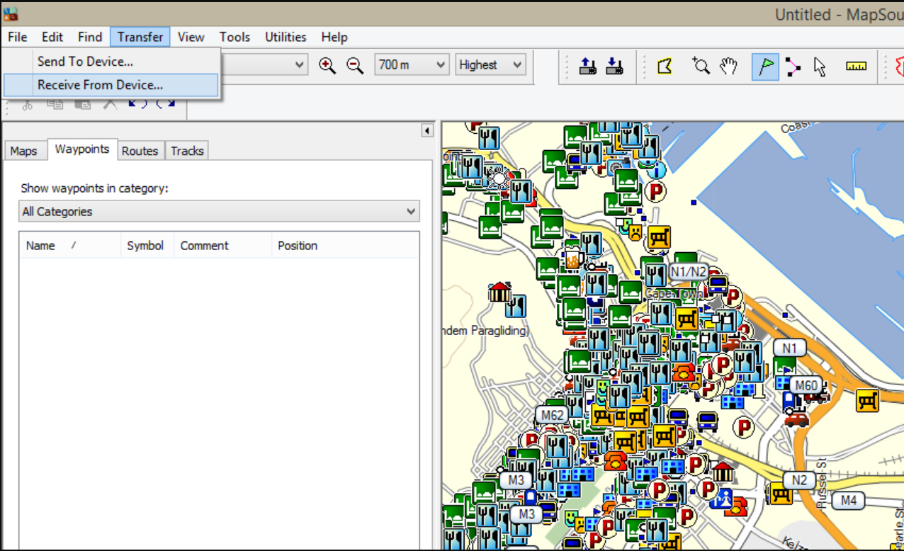
    Click on transfer at the top of your toolbar.

    Select receive from device.

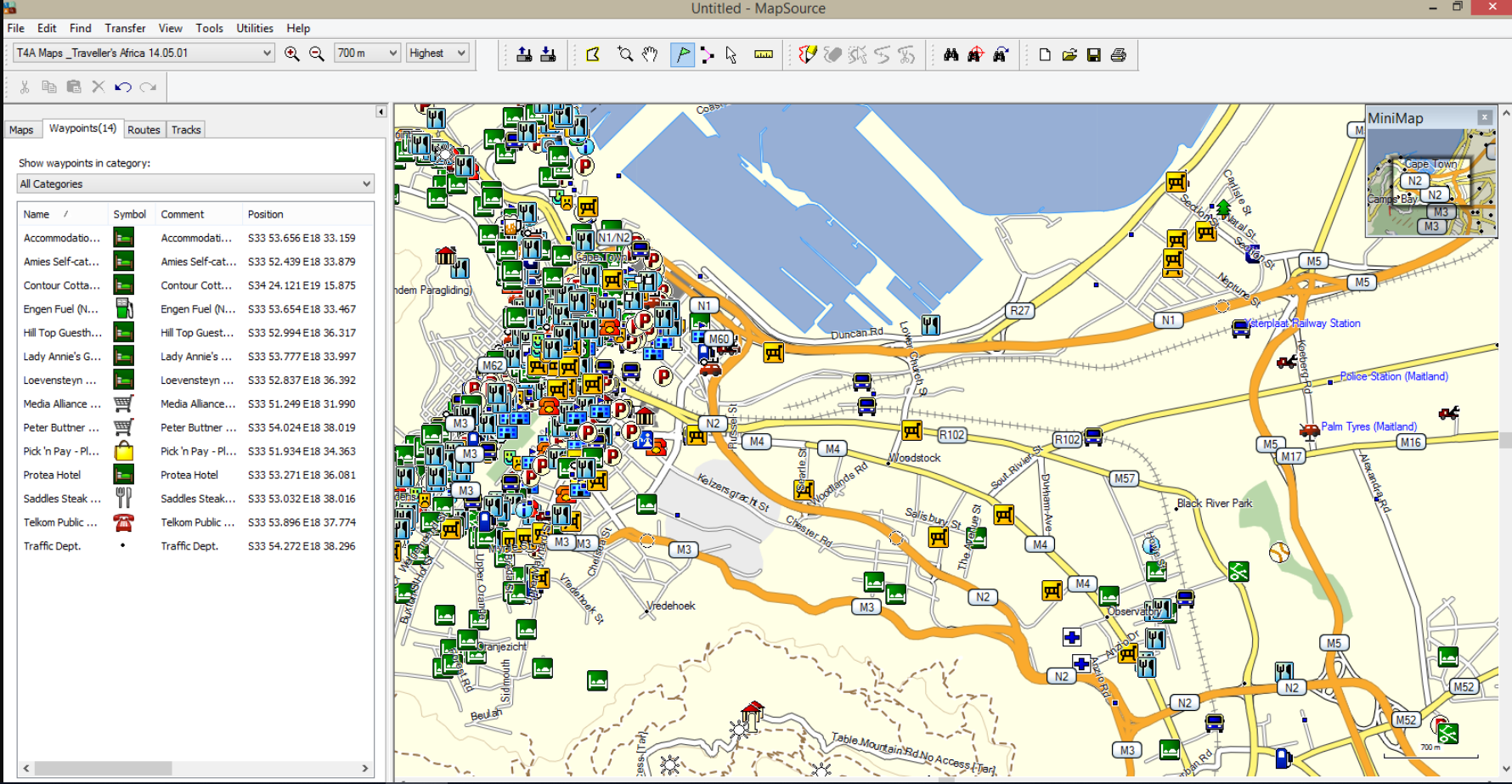
    The following window will open up.

    Tick the boxes of what you would like to receive.

    Click on receive.

    The data will be listed on the left hand.

    Save it to your desktop by going to File > Save As.Save the file in the file format as Mapsource prescribes ie. .gpx format

    You can then send the saved file to Newdata at Tracks4Africa.

    On GARMIN BASECAMP

    Click on Device on the toolbar.

    Select Receive from Device.

    Select the device name to receive data from and click OK.

    The data received from your GPS unit and imported, will then be listed on the left hand side.

    Save it to your desktop by going to File > Save As.Save the file in the file format as BaseCamp prescribes ie. .gdb format

    You can then send the saved file to Newdata at Tracks4Africa.

  • 37) GPS MAPS: IS IT POSSIBLE TO SEARCH FOR STREET NAMES ON MY TRACKS4AFRICA MAP?

    T4A maps are not street maps; however, you can search for streets that are labelled. Most of the streets in South Africa are included.

    Street names that are labelled on our maps are searchable but you won’t be able to search for a specific street number.

    All Suburbs in South Africa are searchable.

  • 38) GPS MAPS: WHAT IS GARMIN BASECAMP AND MAPINSTALL AND WHY DO I NEED IT?

    Garmin BaseCamp is an application which enables you to view Garmin compatible maps on your Windows PC and Macintosh, do route planning and transfer waypoints, tracks and routes between your PC/Mac and your Garmin GPS device. This is a FREE application from Garmin and it will eventually replace MapSource.

    Click here for the link to install BaseCamp for Windows

    Garmin MapInstall is also a FREE application which enables you to transfer Garmin compatible maps on your Windows PC and Macintosh to your Garmin GPS unit. Note that MapInstall is a feature incorporated within Garmin BaseCamp too.

    Click here for the link to install MapInstall for Windows

  • 39) GPS MAPS: WHAT IS GARMIN MAPSOURCE AND WHY DO I NEED IT?

    Garmin MapSource is a FREE application which enables you to view Garmin compatible maps on your Windows PC, do route planning and transfer maps, waypoints, tracks and routes between your PC and your Garmin GPS device.

    MapSource is very similar to BaseCamp, although many people prefer it as it’s easier to use. However, MapSource will eventually be phased out.

    NOTE: You must have Garmin BaseCamp / MapInstall, installed on your PC before you can install Garmin MapSource.

    Click here for the link to install MapSource for Windows

  • 40) GPS MAPS: IS IT POSSIBLE TO HAVE BOTH THE TRACKS4AFRICA MAPS AND THE STREET MAPS LOADED ON MY GARMIN GPS UNIT?

    Yes, you can have both map sets on your Garmin GPS device, but you may not have them both switched on at the same time.

    Please note that some of the Garmin GPS units have the Street maps pre-loaded on the internal memory of the GPS unit which in some cases can’t be overwritten by sending a new map to the internal memory.

    If your Street maps aren’t pre-loaded on your GPS and you wish to have both the Tracks4Africa maps and the Street maps on your GPS, then you’ll need to transfer both these mapsets simultaneously to your Garmin GPS unit.

    If you don’t have the Street maps loaded on your PC to transfer to your GPS (using Garmin MapSource or Garmin MapInstall) you can transfer our Tracks4Africa maps to a separate SD Card. This will then provide you with the option to have both maps sets available simultaneously on your Garmin GPS unit, which will enable you to switch between the two map sets.

    Please note that you can only have one map set selected at a time otherwise your GPS device will give navigational problems.

    NB! If you bought a SD Card from one of our retailers, then please ensure that your SD Card is registered on our website. We will then have your details on our records and provide you with your upgrade if eligible as well as discounts on our online shop.

  • 41) GPS MAPS: I HAVE A GARMIN 76CX, 276, 60CSX AND I’M HAVING DIFFICULTIES LOOKING UP A STREET ADDRESS ON MY GARMAP MAPS WHEN THE TRACKS4AFRICA MAPS ARE ALSO ON MY DEVICE. HOW CAN I SOLVE THIS PROBLEM?

    To solve this problem you must have your Street maps and T4A maps on two separate memories. You can have the one on the GPS internal memory and the other one on a separate SD card.

    REMEMBER! Each time a map set is sent to a Garmin GPS the previously loaded maps are erased from the GPS. If your Garmap maps are on your SD card, send your T4A maps to the internal memory on your device and vice versa.

  • 42) GPS MAPS: I AM UNABLE TO LOCATE ANY POIS ON T4A WITH MY GPS.

    The GPS will only search for POIs (Points of Interest) within a certain radius (typically 1 000km) of your current location and won’t pick up any POIs outside of the radius.

    The way around this is to:

    • Ensure that the T4A maps are the only maps switched on.
    • Set the GPS into Demo mode / Simulation mode. (under Settings > Navigation).
    • Then set New Location to a point closer to the area you want to search for POI’s. Select a New Location by pointing the arrow to a position on the map and select Enter. You will then be able to search for POI’s within the radius of the new location that you have just entered.
  • 43) GPS MAPS: “A REFERRAL WAS RETURNED FROM THE SERVER” INSTALLATION ERROR WHEN TRYING TO INSTALL T4A GPS MAPS EXE FILE.

    When attempting to install applications in any Microsoft Windows version, some users may experience an error that says “A referral was returned from the server”.

    This is generally due to an incorrect system setting.

    You can find detailed instructions on the internet to bypass this error. We suggest you google for a solution for your particular Windows version eg. “a referral was returned from the server Windows 10”.

    A Windows 10 Fix is typically: To solve this problem, try these steps.

    Fix 1 – Registry Setting:

    Download and run referralfix.zip and run referralfix.reg to automatically apply these changes to your computer.

    • Hold the Windows Key and press “R“.
    • Type “regedit“, then press “Enter” to bring up the Registry Editor.
    • Navigate to HKEY_LOCAL_MACHINE \ SOFTWARE \ Microsoft \Windows \ CurrentVersion \ Policies \ System.
    • Open “ValidateAdminCodeSignatures” and set “Value data” to “0“
    • Open “EnableUIADesktopToggle” and set the “Value data” to “0“.

    Fix 2 – Group Policy

    • Hold the Windows Key and press “R“.
    • Type “gpedit.msc“, then press “Enter” to bring up the Local Group Policy Editor.
    • Expand “Computer Configuration” > “Windows Settings” > “Security Settings” > “Local Policies” > “Security Options“.
    • Change the “User Account Control: Only elevate executable that are signed and validated.” policy to “Disabled“.
  • 44) GPS MAPS: I HAVE A GARMIN NUVI GPS UNIT, AND THE POI’S (POINTS OF INTEREST) AREN’T VISIBLE AT A CERTAIN ZOOM LEVEL.

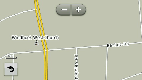
    On the Garmin Nuvi range you will have to zoom into the map to about 30 – 50m to see any POIs displayed. Garmin Nuvis are City Navigators i.e. it won’t display all your POIs at the same zoom level as an outdoor GPS unit would.

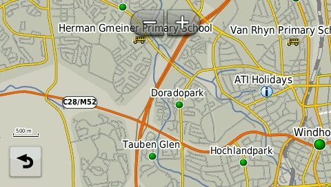
    Examples of the map at different zoom levels on a Garmin Nuvi.

    500m Zoom Level


    30m Zoom Level


    The newer Nuvi units were purposely engineered to limit the amount of POIs that display on the screen to avoid cluttering. Therefore you won’t be able to see all POIs at 80m zoom level. To view POIs (Points of interest) on your GPS, either search for the point under ‘Where To’ (on the main menu) or make a waypoint on the GPS or transfer a waypoint from MapSource / BaseCamp in order to have the POI displayed on the map when viewing.

  • 45) GPS MAPS: CAN I LOAD MY TRACKS4AFRICA GPS MAP ON A SD CARD BIGGER THAN 8GB?

    Most Garmin GPS units won’t function with an SD cards that has a capacity of more than 8GB, as the memory will be too big for the GPS to handle and you won’t be able to locate the Tracks4Africa GPS Maps on your GPS unit.

  • 46) GPS MAPS: IS IT POSSIBLE TO GET THE T4A MAP ON MY CELL PHONE IF IT HAS A GPS SETTING?

    Yes, we have an app available for iPhones, iPad’s and Android devices. Tracks4Africa Overland Navigator brings you the Tracks4Africa maps for Southern and Eastern Africa as an app. Once installed and activated via internet connection, the app and content is available offline and can be used without an internet connection.

    The countries covered in this version of the app are: South Africa, Lesotho, Swaziland, Namibia, Botswana, Zimbabwe, Mozambique, Angola, Zambia, Malawi, Tanzania, Burundi, Rwanda, Uganda and Kenya.

    The app itself is based on iGO navigation, provided by NNG. They specialise in developing navigation solutions for mobile, PND and automotive applications.

    The download is approximately 622MB.

    Have a look at our FAQ Page for T4A Overland Navigator – iPhone/iPad/ Android

    Attention iPad Users:

    If you want to take full advantage of the Tracks4Africa Overland navigator you need to have an iPad with a GPS installed. (Note: some iPads only have WiIFiI and no 3G, in which case you will have a problem with our app). What you need to understand is that iPads with 3G also have a GPS receiver built in. The iPads with only WiFi does not have a GPS receiver built in but can still determine your approximate location when in range of a WiFi network.

    This holds true for all iPad models: iPad2, iPad3 and iPad Mini. This information is valid up to August 2014 when this document was written, Apple may in future change how they package their products.

    For a more detailed explanation on this, please read more.

    ANDROID USERS: Please note!

    If you want to take full advantage of the Tracks4Africa Overland navigator now available on the Google Play as well for Android users. Follow this link to the Google Play store:

  • 47) GPS MAPS: IS TRACKS4AFRICA COMPATIBLE WITH A WINDOWS 7, 8 AND 10 OPERATING SYSTEMS?

    Yes, Tracks4Arica maps are compatible with Windows 7, Windows 8 and Windows 10 Operating Systems.

  • 48) GPS MAPS: I SUCCESSFULLY INSTALLED THE T4A MAPS BUT, I CAN’T LOCATE THE MAP ON MY PC / MAC?

    To view our Tracks4Africa maps on your PC / MAC, please follow the steps below:

    PC:

    Go to Start > Garmin Folder.

    Look for Garmin MapSource / Garmin BaseCamp and open it.

    In Garmin MapSource, look for View on the top toolbar > Switch to product > select the map you wish to view on the dropdown menu.

    In Garmin BaseCamp, look for Maps on the top toolbar > select the map you wish to view on the dropdown menu.

    MAC:

    Select Go on the top toolbar > Applications.

    Under Applications select Garmin BaseCamp.

    In Garmin BaseCamp, look for View on the top toolbar > Select > Switch to product > select the map you wish to view on the dropdown menu.

  • 49) GPS MAPS: I CAN’T SEE MY GPS LISTED ON MY COMPUTER

    If you have an old Garmin GPS unit like a Garmin 276csx and have a computer with a Windows 7, 8 or later operating system, then your PC won’t detect the GPS as it’s too old for the operating system. This applies to the newer Macintosh operating system Maverick as well.

    If you can’t detect the GPS on your PC / MAC whilst having one of the latest GPS units and operating systems, try to install Garmin USB drivers from Garmin’s website:

    http://www8.garmin.com/support/agree.jsp?id=591


    If you have upgraded to Windows 11:

    It is apparent that the device drivers in Win11 do not include that which is needed for the old 276c device.

    You can try this: Follow these steps:

    1) Download the latest USB Drivers Software: Garmin: USB Drivers Updates & Downloads

    2) Install the latest web updater: https://www8.garmin.com/support/download_details.jsp?id=931

    after installing both of these and doing a restart, BaseCamp should now recognise the 276c (note Not the 276cx)


  • 50) GPS MAPS: THE T4A MAPS AREN’T VERY DETAILED IN GARMIN BASECAMP. WHAT CAN I DO TO SEE MORE DETAIL? (INSTRUCTIONS FOR WINDOWS AND MAC)

    You can increase the map detail by doing the following:

    Zoom in and out of the map in order to see more detail (on the top toolbar go to View > Zoom in)

    Example of GPS map at two different zoom levels:

    70km Zoom Level


    700m Zoom level


    Then also check the following:

    Windows PC:

    Open BaseCamp

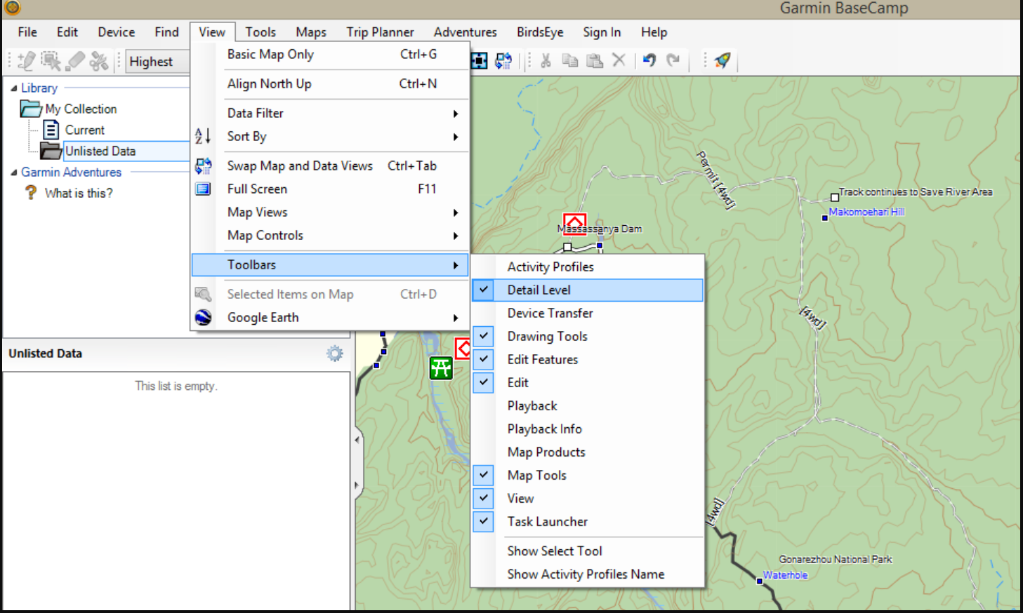
    On the top of the toolbar go to View > Toolbars > Click on Detail level (you need to enable it).


    Your map detail is now set to Highest.


    On a MAC:

    Open BaseCamp.

    Look at the bottom of the BaseCamp screen for this window.

    Move the cursor towards the plus sign to increase the map detail on your map.


    Your map detail is now set to highest.

  • 51) GPS MAPS: NEW GPS MAPS RELEASED POIS’ SEEM TO BE LESS THAN PREVIOUS RELEASES?

    Firstly, please check that your Map Detail on Basecamp is set to highest – refer to “22. The T4A maps aren’t very detailed in Garmin BaseCamp. What can I do to see more detail? (Instructions for Windows and Mac)” on our FAQ page.

    Secondly, please note the following:

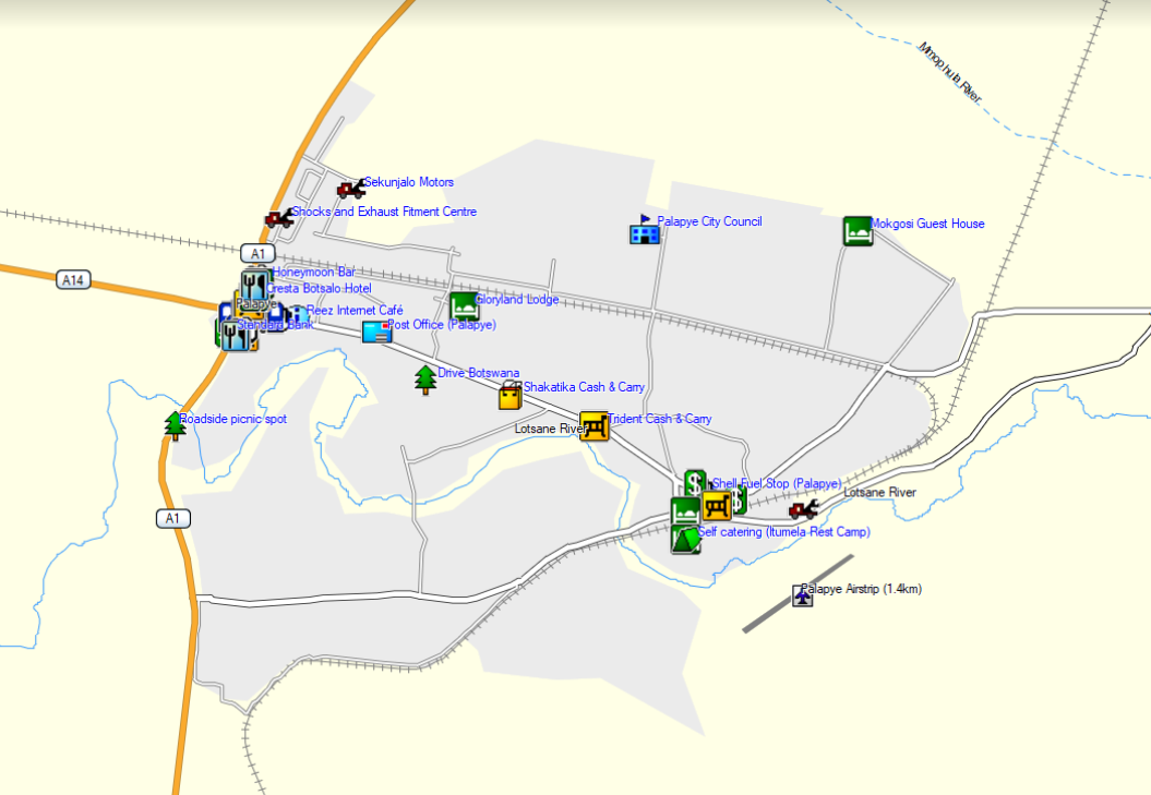
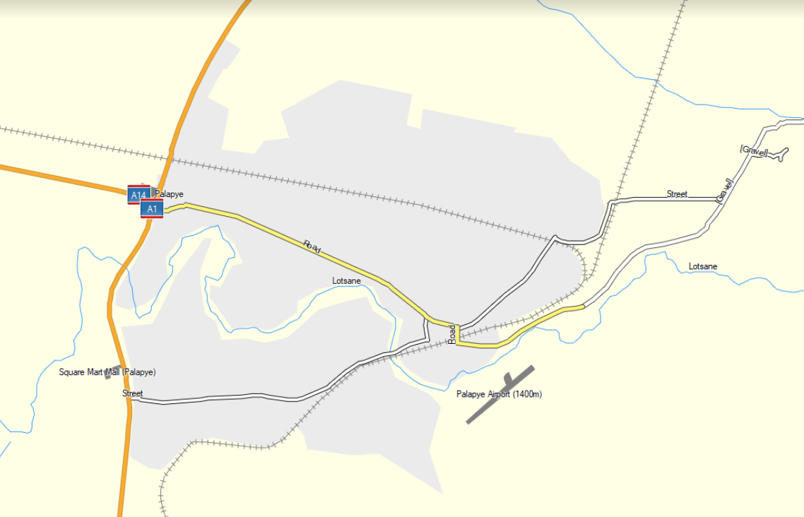
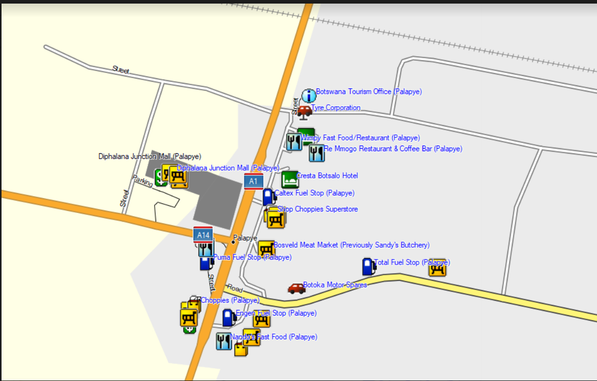
    As our map products grow and the maps get larger with more information, map performance and functionality have to be compensated for. We do not remove any information or release a map with less information on it as a previously released version. For example a town e.g. Palapye: on our 14.10 release you may have seen this town and its POIs appear as follows at a certain zoom level:


    Then, when you view the same town on our new map version, for example 18.05 at the same zoom level you may see the following:


    This difference in appearance has to do with at what zoom levels the different kinds of info is switched on and displayed. More info at higher zoom levels makes the maps much more heavy and slower. On the contrary, 18.05 has more info than older maps e.g. Palapye:


    The info in 18.05 is thus only switched on at one or two zoom levels lower than the previous versions, but there is definitely more info. This is a necessary evil in order to have a balance between good performance and information. A heavy and slow map will cause much frustration regarding usability.

  • 52) GPS MAPS: LOADING T4A GPS MAPS TO THE NEW GARMIN NUVICAM LMTHD WITH 2 MEMORY CARDS

    The new GARMIN nuviCam LMTHD with the built-in Camera comes with 2 memory cards.


    When loading the map to the device using Mapinstall, the installer loads the map to the memory card but, since this is a new model GARMIN with 2 cards the installer does not know the difference between the camera memory card or the map memory card.

    With both cards slotted in, the Tracks4Africa map could be loaded to the camera memory card – the GARMIN nuviCam LMTHD will then show an error asking to move the memory card to the map slot.

    To overcome this problem: remove the camera memory card to ensure Mapinstall can see only the map memory card and try again. The Tracks4Africa GPS map should then be successfully loaded onto the correct memory card in the maps memory slot.

  • 53) GPS MAPS: THE GPS TELLS ME THAT THE NEWLY BOUGHT SD CARD VERSION 18.05 REACHED THE END OF ITS LIFE AND THEREFORE COULD NOT LOAD IT.

    This problem has been reported mainly on the Garmin Drive/Assist range – but follow the instructions below for any Garmin model.

    Copy the contents of SD Card to your desktop and then format the SD Card, then copy only the “Garmin Folder” to the SD Card.

  • 54) GPS MAPS: HOW DO I TRANSFER MAP/S TO MY GARMIN GPS OR COMPATIBLE DEVICE USING GARMIN MAPINSTALL ON MY WINDOWS PC?

    Maps are viewed in Garmin BaseCamp and then transferred via Garmin MapInstall from your PC to the GPS.

    Step 1: To install BaseCamp on your PC, visit http://www8.garmin.com/support/download_details.jsp?id=4435 and follow the on screen instructions.

    Step 2: To install MapInstall, visit http://www8.garmin.com/support/download_details.jsp?id=3291 and follow the on screen instructions.

    You now have a legal working copy of Garmin BaseCamp and MapInstall.

    If you already have BaseCamp on your PC, go to HELP to CHECK FOR SOFTWARE UPDATES and make sure you are using the latest version. The steps below are applicable to BaseCamp v3.3.3 (or later) and MapInstall v4.0.1 (or later).

    When sending the map/s, MapInstall should be open and your GPS system switched on and plugged in. Each time a map set is sent to a Garmin GPS the previously loaded maps are erased from the GPS. If your Garmap maps are on your SD card, send your T4A maps to the internal memory on your device and vice versa.

    To transfer maps to your device, open MapInstall.

    NB! If you have a older version on your internal memory of the GPS or an SD Card then, you must remove it before transferring the new maps to your GPS unit. Explore the internal memory  / SD Card and look either under the Garmin folder or map folder for the file ending with img. Cut this file and place it on your desktop for safety. After following the steps below, where the new maps are place successfully on your GPS. You may remove the img file form your desktop. 

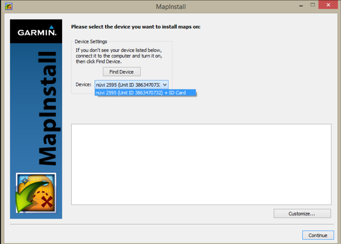
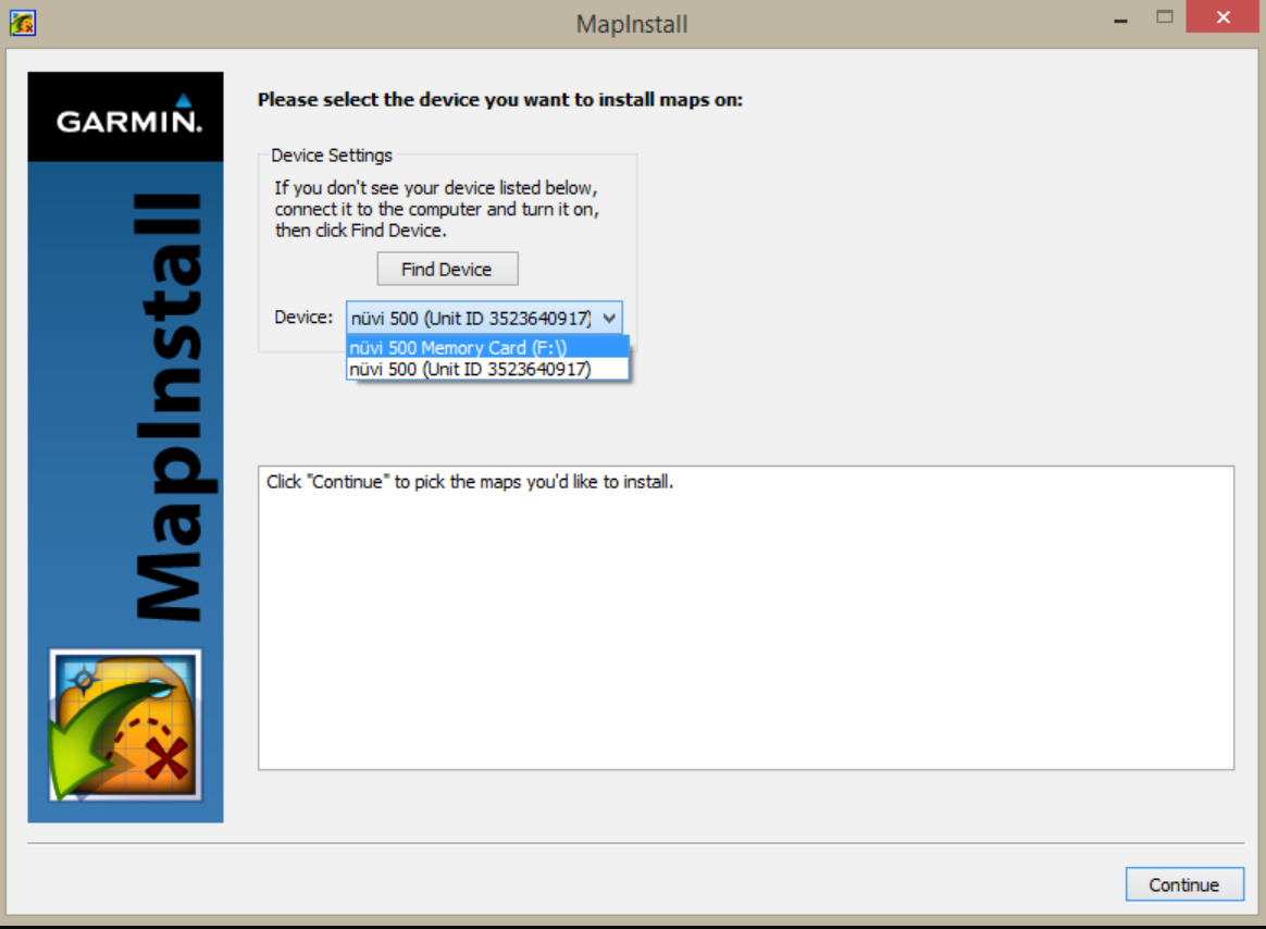
    The device + SD card should be listed in one line. If you want to transfer maps to the internal memory of your device, make sure that no SD card is inserted in the device.

    If you want to transfer maps to the SD card in your device, simply insert the SD card into the GPS.


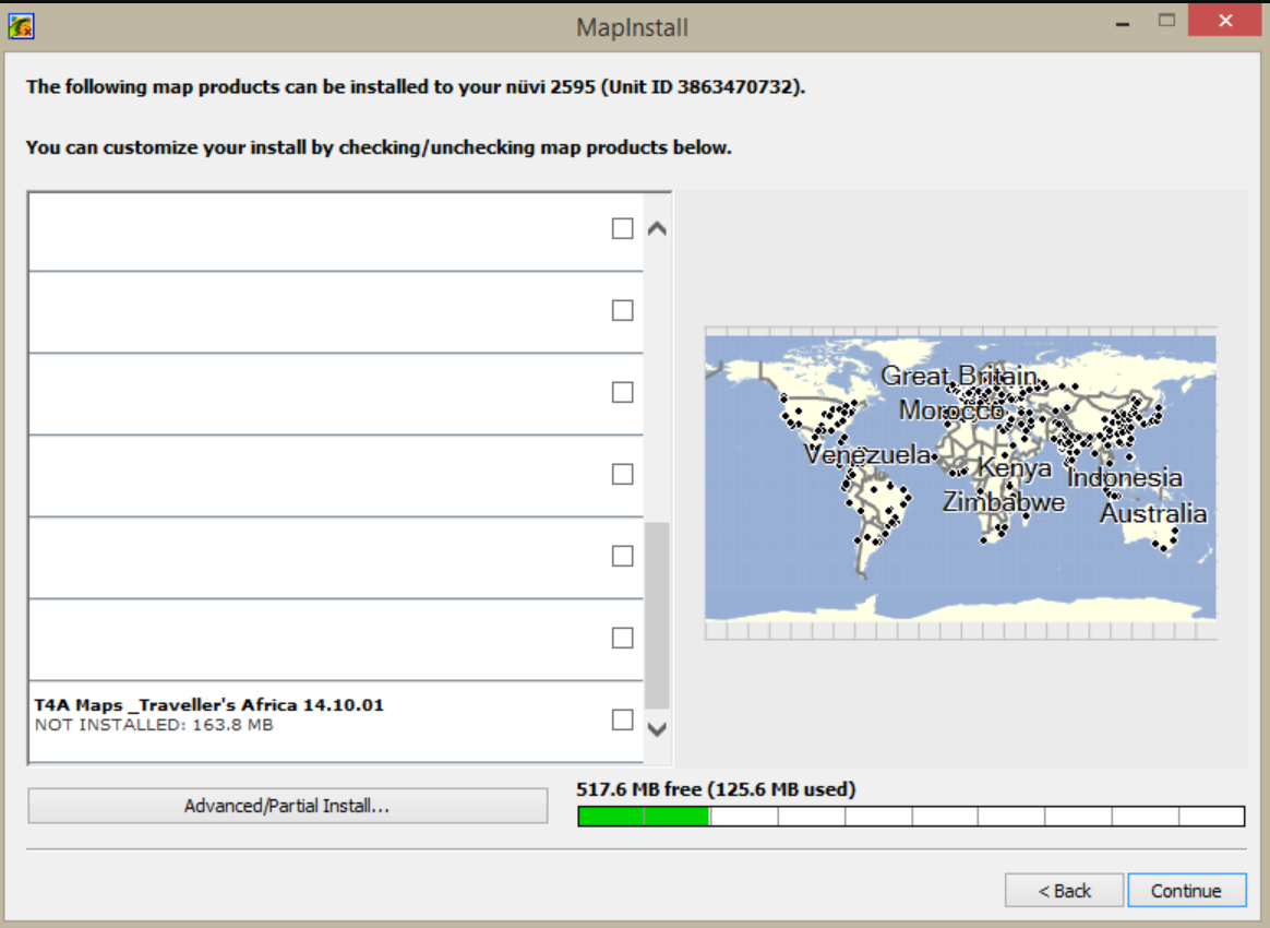
    For some older units (GPS units from 2010 and earlier) the SD card and unit name will be listed separately. In that case, make sure you select the destination for the maps. Click on Continue and select the maps you want to send:


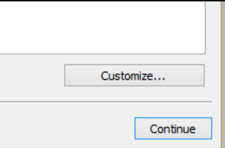
    If you are using a newer device, click on CUSTOMIZE to select the map(s) you want to send to your device.


    Click on the map name of the map that you want to send to your device. Your map will be highlighted on the screen. Click on continue:


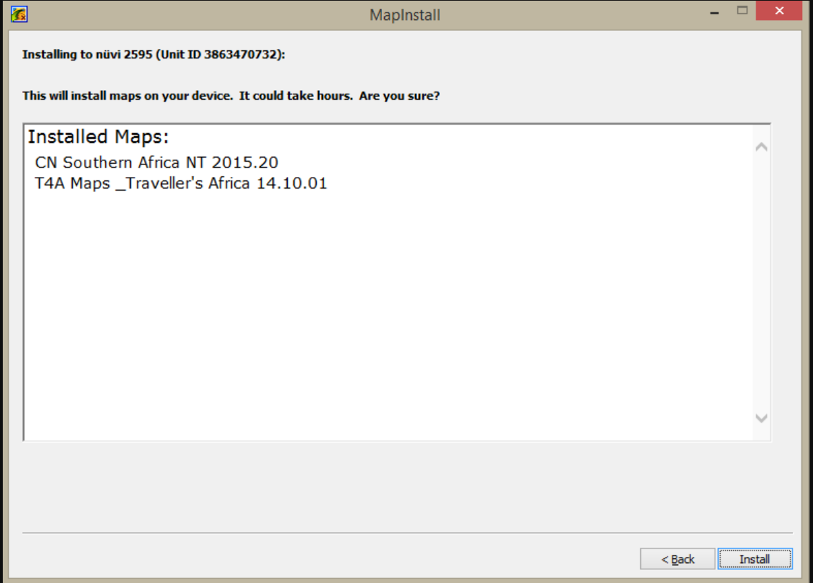
    Click on Install.


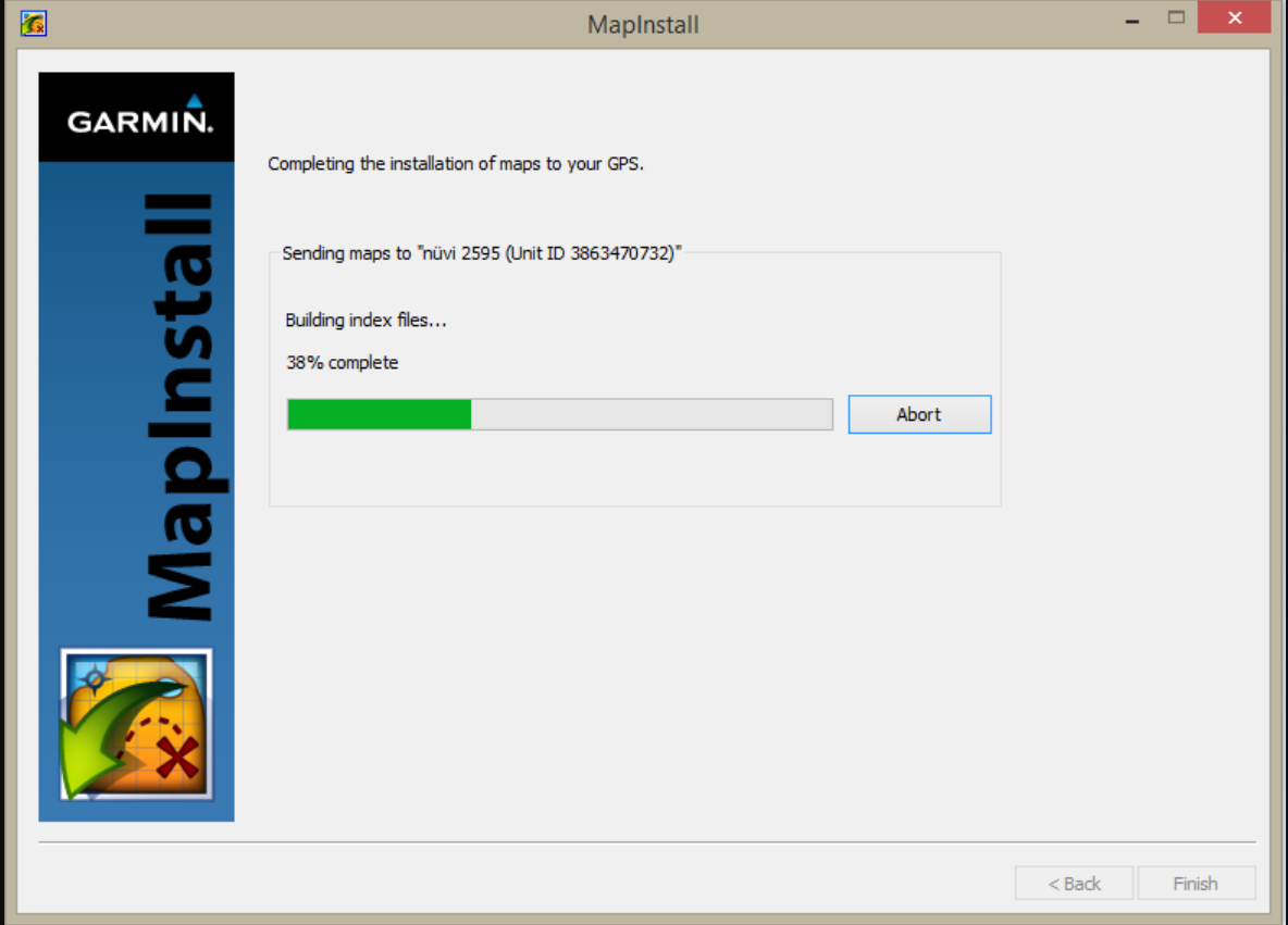
    The following screen will appear:


    To check whether the maps were successfully sent, switch on your Garmin GPS device, go to SETTINGS >MAP & VEHICLE >My MAPS and check whether T4A is listed (note steps to check whether the maps are loaded may vary depending on which GPS you’re using).

    This can take a few minutes (note it shouldn’t take hours). When the installation is done, click FINISH.

  • 55) GPS MAPS: CAN I SEND THE WAYPOINTS WHICH ARE LISTED UNDER MY FAVOURITES ON MY GPS TO GARMIN BASECAMP / GARMIN MAPSOURCE?

    Yes, all listed waypoints which are under your Favourite, can be retrieved. Please follow the steps below:

    On Garmin BaseCamp, follow these steps:

    Connect the GPS unit to your PC / MAC.

    Open Garmin BaseCamp.

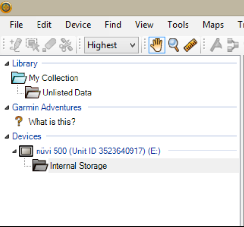
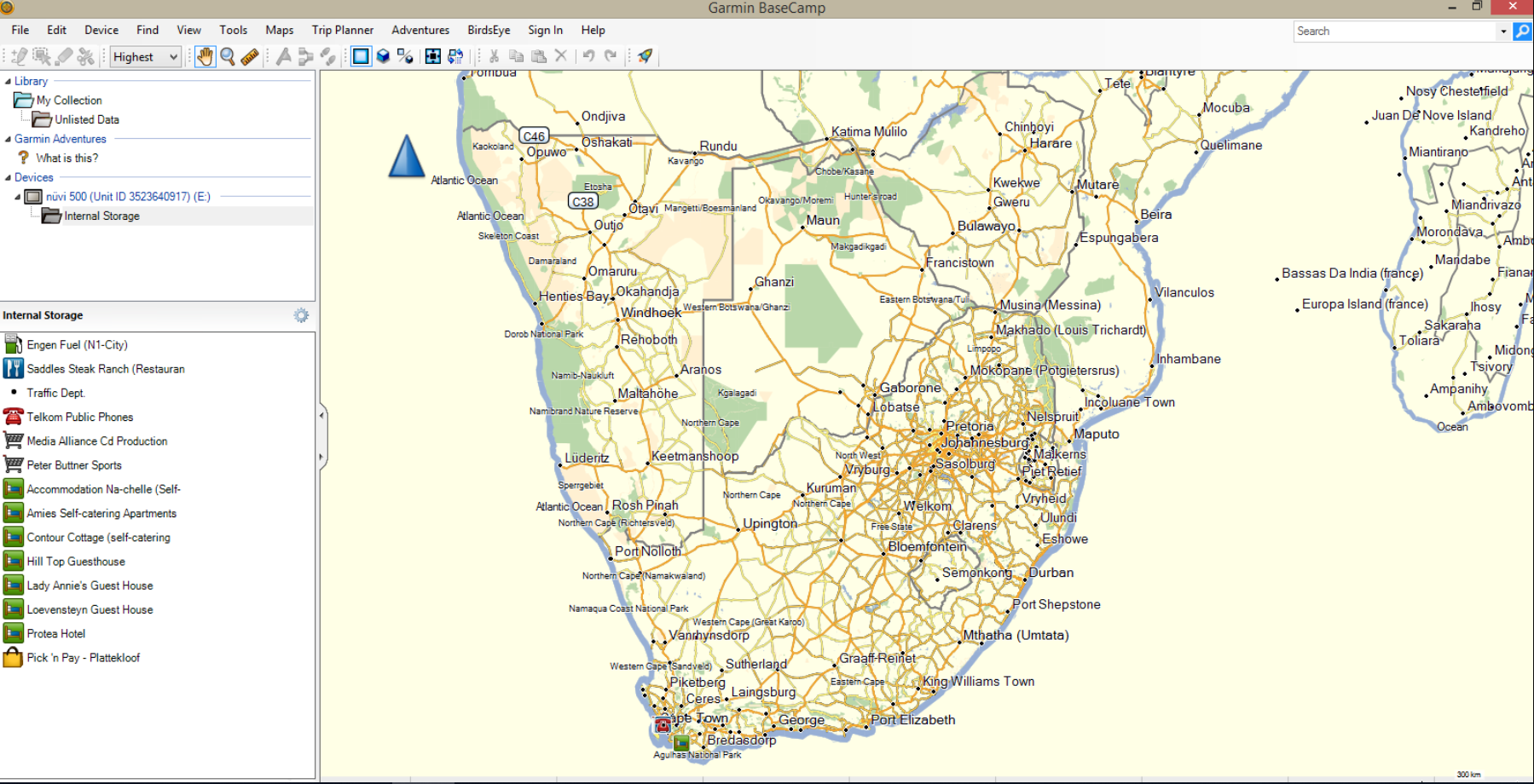
    Look for the GPS unit listed under devices on the left-hand corner of the screen and click on Iinternal Storage.


    The waypoints will be listed under the Internal Storage window. You may then save the waypoints under My collection (Edit > Send to > My Collection) for easy retrieval once needed.


    On Garmin MapSource, follow these steps:

    Connect your GPS to your PC.

    Open Garmin MapSource.

    Select Transfer> Receive from device.


    All the waypoints saved under your favourites on your GPS will now be listed on Garmin MapSource.

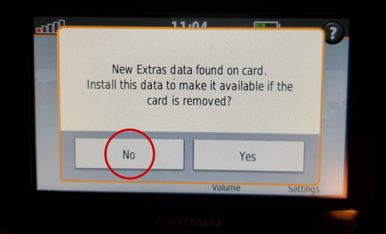
  • 56) GPS MAPS: “NEW EXTRAS DATA FOUND ON CARD. INSTALL THIS DATA TO MAKE IT AVAILABLE IF THE CARD IS REMOVED?” – WHAT TO DO WITH THIS MESSAGE WHEN GARMIN GPS UNIT IS SWITCHED ON?

    When switching on your Garmin GPS Unit, while the T4A GPS Maps on SD card is inserted in the unit – you may see the message as per below appear – choose “NO”.


    This means that the Garmin unit has picked up that there is an extra data file on the SD Card. In this case it has picked up on the Africa Guide, that is supplied by T4A, and included on our SD Cards. It is not necessary to install this onto your GPS unit, as you can access it directly from the SD Card. This is also a very large file, of over 800MB in size. See here for more info on the Africa Guide.

    Also note – if you choose “YES” here : The ‘extras’ that are transferred to the GPS are the T4A Africa Travel Guide file not the maps. The SD card HAS to be inserted in the GPS when you want to use T4A maps.

  • 57) GPS MAPS: MAPSOURCE COMPATIBILITY WITH OLDER GARMIN GPS UNITS

    Mapsource will only be compatible with older Garmin GPS units.

    Mapsource was phased out many years ago by Garmin, so there is no new updates on it, hence it keeps on working. But as Garmin introduces new GPS models these are not compatible with Mapsource. Mapsource will not work with new units from the last three years.

    Basecamp is compatible with new and old Garmin GPS units – however in the latest Basecamp update there is a problem with transferring GPS maps from Basecamp to a GPS unit. (June 2018).

  • 58) GPS MAPS: LIMITATION ON NUMBER OF WAYPOINTS THAT CAN BE SENT TO A GPS UNIT FROM BASECAMP

    GPS units, like most other Garmins would take up to 1000 waypoints. But some units seem to limit users to say 100 waypoints.

    Here is a workaround you can try:

    Take your collection of waypoints in Basecamp and export it as a GPX file. Then copy this GPX file (give it a userfriendly name) to the GPS. Place it under Garmin/GPX/ folder.

    You should see several other GPX files in this location. The one called current.gpx is the tracks that currently display on the device.

    There may also be an Archive folder under /GPX/. In here the GPS will store archived track logs, handy if you need to get it in future. Note that GPS stores only 10k track points in current/gpx and then it will archive.

  • 59) GPS MAPS: ANYDESK FREE SOFTWARE WILL ALLOW US TO REMOTELY CONNECT TO YOUR PC!

    From time to time, it’s easier for us to take control of your PC remotely, to assist with a problem.

    AnyDesk is free software that will enable us to do this. Please follow the steps below in order to install it onto your PC.


    1. In Google, search for “anydesk download”. You will see search results similar to this. Go into this link to download it.


    Or go to this link.

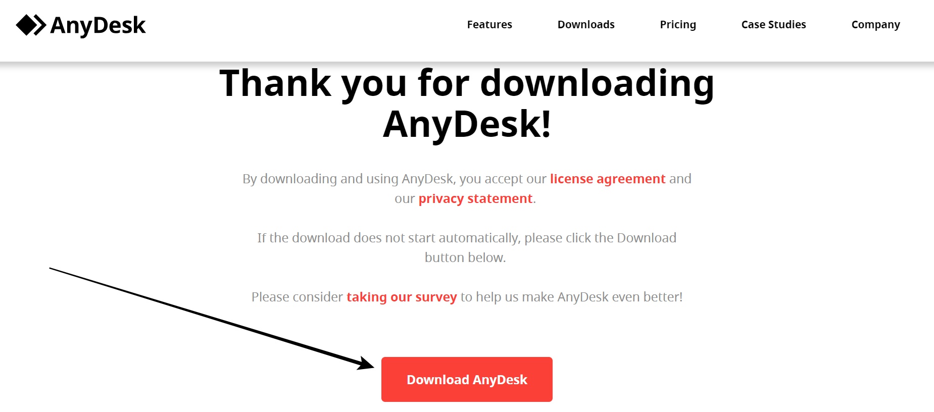
    As soon as you go into the AnyDesk webpage, the EXE for AnyDesk starts downloading in the bottom left of your screen.


    If not scroll down to click on the download button on the AnyDesk webpage.


    Then click on the AnyDesk.exe (in the bottom left corner of your PC / or find the exe in your Downloads folder on your PC) in order to run and install it onto your PC.

    You then get this screen – you can give someone else your AnyDesk address to access your PC or vice versa. “This Desk” represents your PC, and the “AnyDesk Address” is the ‘address’ you need to provide the Tracks4Africa operator with.


    Once access is gained to a PC – the PC owner will see an option to click “allow” in order to allow the Tracks4Africa operator to take control.

    AnyDesk is very easy to use!

  • 60) GPS MAPS: How do I transfer maps from Garmin MapSource to my Garmin GPS or compatible device?

    Firstly maps are sent from Garmin MapSource to your GPS system (if you don’t have Garmin MapSource, please download it from Garmin’s websiteGarmin MapSource is more compatible with GPS units released in 2010 and earlier.

    When transferring the maps;

    Garmin MapSource should be open, your GPS system switch on and plugged in.

    With MapSource each time a mapsets is sent to a Garmin GPS the previously loaded maps are erased from the GPS. If your Garmap maps are on your SD card, transfer our maps to your internal memory and vice versa.

    Step1: In Garmin MapSource, go to View, switch to Product and select the mapset you wish to send. The map will be visible in front of you. If not, zoom in and out to find the map.

    Step2:  Now go to Tools (at the top of the toolbar) and select Map.


    The Map Tool is now selected. With this you can select the map/s you want to send to your GPS. When you click on the map with the Map Tool, the map will becomes pink (see below).


    If you want to send more than one map to your GPS system then just repeat step 1 and 2 or make a big block over the whole of Africa (full set only).

    Step 3: To transfer the maps to your GPS, select Transfer on the toolbar and then select Send to device.


    Step 4: The screen below should appear. Under “Device” you can either choose between the internal memory of the GPS which will be the name of your device (Montana  650t) or the SD card (if you have one inserted in the GPS) which will be listed as Removable disk (F:/) on the dropdown menu.


    Step 5: Your device should be listed. Ensure that Maps are ticked. If you made routes or waypoints on the maps, then this should also be ticked. . Now click Send. The maps will be transferred to your device.

    Your maps should now be listed under Settings > Map > Map info.

    (Please note that the Tracks4Africa GPS Maps may not be used inconjunction with any other GPS Maps).

  • 61) GPS MAPS: The T4A maps aren’t very detailed in Garmin MapSource. What can I do to see more detail?

    You can increase the map detail by doing the following:

    Zoom in and out of the map in order to see more detail (on the top toolbar go to View > Zoom in)

    Example of GPS map at two different zoom levels:

    70km Zoom Level


    700m Zoom level


    Ensure that your Map detail is set to Highest (on the top toolbar go to View > Map detail >  Highest).


    Underneath View it must say HIDE GPS MAP DETAIL as below. If it says SHOW GPS MAP DETAIL, click on SHOW GPS MAP DETAIL to display detail.


    Go to EDIT > PREFERENCES > DISPLAY and ensure that your settings are set up as below:

  • 62) GPS MAPS: My PC runs on Windows 7/ 8 OS. I have trouble viewing my T4A maps in MapSource. After installing my Tracks4africa maps on my PC, Garmin MapSource becomes very slow and sometimes it completely loses the map. Only grid lines and waypoints are visible then.

    You will need to update Garmin MapSource on your PC. Restart your PC and see if the problem persists.

     http://www8.garmin.com/support/download_details.jsp?id=209

    If you still have issues with MapSource, then rather use Garmin BaseCamp and Garmin MapInstall, installation instructions below:


    • Garmin BaseCamp is an application which enables you to view Garmin compatible maps on your Windows PC and Macintosh, do route planning,  make waypoints and create tracks and routes between your PC/Mac and your Garmin GPS device. This is an application from Garmin and it will replace MapSource one day.
    • Garmin MapInstall is an application which enables you to transfer the map to your GPS unit. You will use this application with Garmin BaseCamp.
  • 63) GPS MAPS: I bought the links online for my Windows PC. How do I install them unto my PC now?

    1. Click on the link (T4A Map).
    2. You’ll be asked to Run or Save the file. Select the Save option.
    3. Save the file to desktop (this is to find it easily again).
    4. When the download is completed, open the saved file on your desktop by double clicking on the zip folder.
    5. Click on the file inside(exe file) and follow the instructions given.
    6. Open Mapsource / BaseCamp and select the map/s to view.
  • 64) GPS MAPS: How do I install the maps on my T4A SD Card on my Windows PC?

    Please see our User Guides for SD Cards, under our Tutorials & Videos FAQ category.

    The SD Card is supplied in a package, which contains the installation instructions.

    The instructions will be as follows:

    (You need to have Garmin MapSource or Garmin BaseCamp installed to view T4A GPS Maps on your PC).

    • Insert the SD card into a SD card reader connected to your PC (your Plug & Play GPS can be used for this purpose).
    • If it is still open, close MapSource or BaseCamp on your PC.
    • Browse the SD Card and double click on ‘PC Install Files/T4A GPS Maps_Travellers Africa_xxxx.exe’.
    • Follow the instructions to install the maps on your PC.
    • Now open Garmin MapSource or Garmin BaseCamp and select T4A Maps from the Product menu.
  • 65) GPS MAPS: How do I uninstall previous versions of Tracks4Africa map/s on my PC before installing the new version?

    It is imperative to please uninstall any previous versions of T4A before installing newer T4A Maps. The GPS Map Installers may throw all the files into a different directory on the PC and then BaseCamp and MapSource gets confused. But this can easily be avoided if the customer just uninstalls all previous maps of the same region/map and reinstalls.

    How do I uninstall T4A Maps?

    See these examples of different ways in which you can do this – depending on what type of PC you are using:

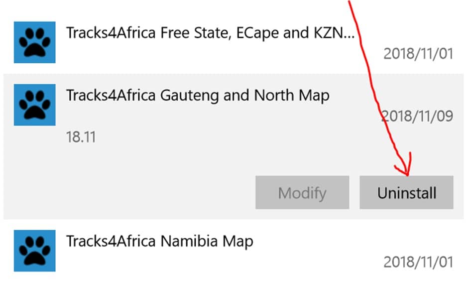
    Generally, on any Windows PC you go to: Control panel >> Programs and Features. Click on the Tracks4Africa Map from the list and then on “Uninstall” to uninstall it.

    Or try these steps on a Windows PC:

    1. Go to Start (at the bottom left side of your taskbar).
    2. Click on All programs.
    3. Look for a Tracks4Africa / T4A Maps Pro folder. 
    4. Highlight it (Tracks4Africa / T4A Maps Pro Folder).
    5. The drop down list will show all T4A maps that can be uninstalled.
    6. Uninstall all unwanted map/s by clicking on the map option to uninstall. (Ie. if all maps must be uninstalled, there is an option to “Uninstall T4A Maps Complete”).

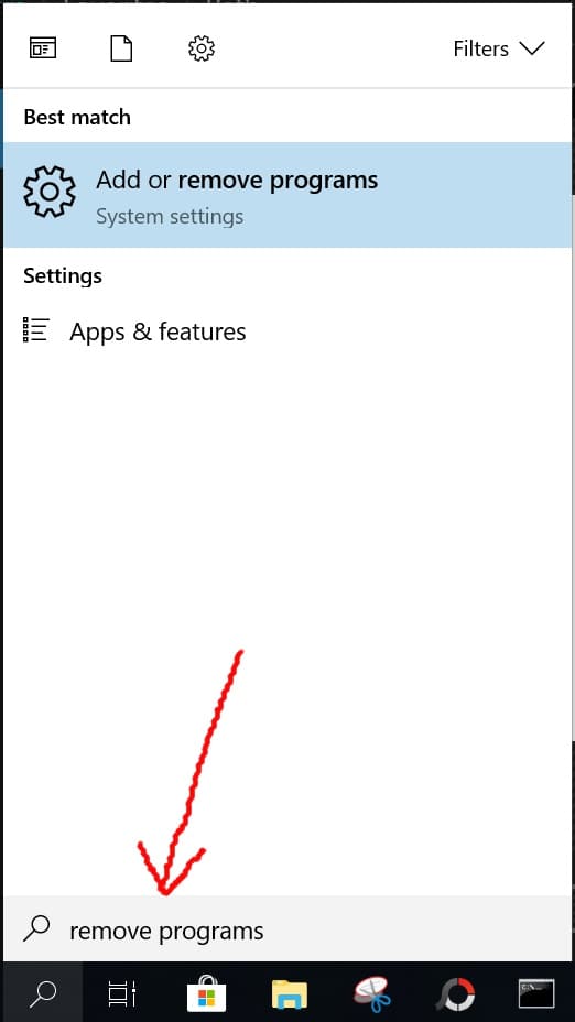
    On Windows 10: You have to go to your settings where you add/remove programs.

    You can go to the start menu (bottom left on windows) – Settings (ie. The gear icon) – Apps – Apps & features.

    OR You can type “remove programs” into your windows search box. Example:


    Then note further up in the small screen box area, where you can click to go into the area to search and remove programs.

    Then once in the Apps & Features menu:

    – Scroll to Tracks4Africa maps, click on the map, and then on “Uninstall” to uninstall the relevant map.


    Can I uninstall T4A GPS Maps directly from Basecamp/Mapsource:

    No, not that we are aware of.

    Do I need to Uninstall T4A GPS Maps on a MAC?

    This is not necessary for MACs, because they make use of the gmapi file.

    You can however remove programs on your MAC – see our FAQ: “GPS MAPS: How do I uninstall previous versions of Tracks4Africa map/s on my Macintosh before installing the new version?


  • 66) GPS MAPS: Error message when I install my Tracks4Africa maps on my Windows 7 PC?

    If Tracks4Africa maps are first downloaded onto Windows XP or Windows Vista PC you will receive the above error message. When downloading a Tracks4Africa link from an online purchase, you have to ensure that you download and install it on your Windows 7/10 PC in order for it to work.

  • 67) GPS MAPS: I accidentally deleted my maps on my Tracks4Africa SD card. Will it be possible to reinstall my Tracks4Africa maps on my PC and Garmin GPS unit?

    Yes, you will be able to reinstall the Tracks4Africa maps on your PC and Garmin GPS.

    If you purchased your GPS maps from Tracks4Africa, we will have record of your purchases, and downloadable maps/subscritpions will also be accessible from your profile on our system for re-download. Contact sales for assistance if required.

    Firstly, our Tracks4Africa SD card contains the installation files for Windows and MAC. Explore the contents on the SD card and look for either the PC (i.e. Windows) installation files folder or the Mac Install files folder.


    The folder contains the installation file for your PC (.exe) or Mac (MAC.zip).

    Once you’ve installed the maps on your PC successfully, you can transfer them from Garmin MapSource/ Garmin MapInstall to your GPS unit.


    Each time a mapset is sent to a Garmin GPS the previously loaded maps are erased from the GPS. If your Garmap maps are on your SD card, send our maps to your internal memory and vice versa.

    Secondly, if you purchased downloadable GPS Maps from us, they should be in your Account, under your subscription – please go and have a look there in order to download.

    Contact our Sales team if you cannot locate your previous GPS Maps.

  • 68) GPS MAPS: I have a Windows 8 / 8.1 Operating system. When I download Tracks4Africa maps from the online store I get an error message saying “Windows Protect your PC” (image below). What should I do?

    The error you get below is just a security measure of the new Windows 8 / 8.1 OS.

    Click on “More info” and select Run Anyway.


    If you get this user account control message, click yes and follow our on screen instructions to install the maps on your Windows 8

  • 69) GPS MAPS: I have a Macbook. Will Tracks4Africa be able to work on it?

    Yes, we have Mac compatible maps. You will need to have BaseCamp and MapInstall software  installed on your Mac.

    Garmin BaseCamp for Mac: to do route planning and view the map on your MAC.

    Garmin MapInstall : to transfer the map to your GPS unit from your MAC.

    Garmin MapManager: your installed maps will be listed here on your MAC; this is also where you will uninstall the maps.

    You can also visit Garmin’s website for Mac OS® Software and Garmin Devices: http://www8.garmin.com/macosx/.

    Notice for Macintosh X Lion 10.07 & Lion 10.7.5 users:

    We have found that the OS X Lion 10.07  and Lion 10.7.5 is incompatible with our maps. In order to install the T4A maps on your system you will need to upgrade your OS to Mountain Lion 10.08.

  • 70) GPS MAPS: What is Garmin MapInstall and Garmin MapManager and why do I need it on my Macbook?

    Garmin MapManager is an application for MAC PC’s only. Once you’ve installed your map (s) on your MAC your maps will be listed here (if you need to uninstall your map(s) from your MAC then you will do it in this application as well).

    Garmin MapInstall is an application which enables you to transfer the map (s) to your GPS unit. You will use this application with Garmin BaseCamp.

    Below is the download to this application:

  • 71) GPS MAPS: How do I install the maps on my T4A SD Card on my MacBook?

    Also see our User Guides for SD Card for MAC, under our FAQ category for Tutorials & Videos.

    The SD card is supplied in a package, which contains the installation instructions.

    The instructions will be as follows:

    (You need Garmin’s BaseCamp and Mapinstall software before you start.)

    • Insert the SD card into a SD card reader connected to your Mac (your Plug & Play GPS can be used for this purpose).
    • If you use your GPS as card reader your Mac will show two volumes on your Desktop: GARMIN and NO NAME. Access NO NAME and open the ‘Mac Install Files’ folder.
    • Copy the contents of the ‘Mac Install Files’ folder to your Desktop and run each file to extract it.
    • This will place new files on your Desktop which can be installed using Mapinstall. Also refe rto Garmin installation instructions for Mac OS.
  • 72) GPS MAPS: I bought the links online for my MacBook. How do I install them unto my MAC now?

    Please also refer to our USER GUIDE for Downloadable links for MAC, under our FAQ category for Tutorials & Videos.

    Rather use Google Chrome or Mozilla Firefox to download the GPS Maps as we have found that the file is corrupt when you use Safari internet browser.

    Please follow the steps below:

    1. Click on the link (T4A Map).
    2. The link will download immediately on your internet browser.
    3. Once done, click on the zip file. The file will extract and your downloads folder will open listing the gmapi file. .
    4. Double click on the gmapi file. Garmin MapManager will open  with a small window in front of it (if you don’t see it then move the Mapmanager window, as it might be located behind it). Click on install and then close.
    5. The map will now be listed on the Garmin Mapmanager program and installed on your Macbook.
    6. Open BaseCamp and select the map/s to view under maps at the top of the toolbar.
  • 73) GPS MAPS: How do I transfer the maps to my GPS device with a Macbook?

    Please also refer to our USER GUIDE for Downloadable links for MAC, under our FAQ category for Tutorials & Videos.

    If you are using a Macbook you’ll need Garmin BaseCamp to view the map(s) and to do route planning on your T4A GPS Maps and Garmin MapInstall to send the map(s) from your Macbook to your GPS device.

    Garmin BaseCamp for Mac: to do route planning and view the GPS Map.

    Garmin MapInstall : to transfer the GPS Map to your GPS unit.

    Garmin MapManager: this is where your installed GPS Maps will be listed and where you will  uninstall your GPS Maps.

    Install these applications from Garmin’s website before continuing the steps below.


    Follow these steps to transfer waypoints, routes and tracks to your GPS unit using Garmin BaseCamp for Mac:

    NB! If you have a older version on your internal memory of the GPS or an SD Card then, you must remove it before transferring the new maps to your GPS unit. Explore the internal memory  / SD Card and look either under the Garmin folder or map folder for the file ending with img. Cut this file and place it on your desktop for safety. After following the steps below, where the new maps are place successfully on your GPS. You may remove the img file form your desktop. 

    • Open BaseCamp.
    • Go to TRANSFER >  SEND “My Collection”. The  window below will open on your screen.
    • Select your GPS or No Name from the dropdown menu. If you select your GPS the data will be transferred to the internal memory of the GPS. If you select the No Name device then the data will be transferred to the SD card in your GPS.
    • Ensure that ROUTES, TRACKS, WAYPOINTS AND GEOTAGGED PHOTOS are ticked. Then click Send.


    Close after the transfer has been completed. All your waypoints will be listed on your GPS under Favourites. If your GPS can receive routes the routes you  have created will be listed under your Trip planner (depending on your GPS model).


    To transfer the map(s) to your Garmin GPS using Garmin MapInstall:

    Each time a map set is sent to a Garmin GPS the previously loaded maps are erased from the GPS. If your Garmap maps are loaded on your SD card, send T4A maps to the internal memory of your device and vice versa. Please note that the SD card has to be inserted in the GPS device if you want to transfer maps to the SD card. Remove the SD card from the GPS device if you wish to have the GPS Maps sent to the internal memory of the GPS.

    NB! If you have a older version on your internal memory of the GPS or an SD Card then, you must remove it before transferring the new maps to your GPS unit. Explore the internal memory  / SD Card and look either under the Garmin folder or map folder for the file ending with img. Cut this file and place it on your desktop for safety. After following the steps below, where the new maps are place successfully on your GPS. You may remove the img file form your desktop. 

    Connect your GPS device to your Macbook in order to transfer the GPS maps.

    Step 1:  Open MapInstall b> Go > ApplicationsGarmin MapInstall.

    To transfer maps to your device’s internal memory, remove the SD card from your GPS and connect to’ GPS unit into your Macbook. The GPS will be listed Nuvi 3790 (unit ID 3820880631)


    If you want to transfer maps to the SD card in your device, then insert the SD card in your GPS and plug it into your Macbook. The GPS will be listed Nuvi 3790 (unit ID 3820880631)+ SD Card.


    Step 2:  Click on CUSTOMIZE to select the map(s) you want to send to your device.


    Step 3: Click on the map name that you want to send to your GPS device. (Once the map is selected, it will be highlighted on the screen).


    Step 4: Click on Send Maps on the bottom right hand corner of MapInstall to transfer the maps to your GPS device.

    Step 5:  The following screen will appear below.

    Click on confirm.

    Please note that the transfer should not take hours as indicated on the screen.


    Step 6: Once the transfer is successfully done you’ll see the page below.

    Click on Done once the installation is complete.


    The maps will now be listed under your Map Information on the GPS. Select the maps by ticking the box next to the map name or by enabling it. (Please note that the Tracks4Africa GPS Maps may not be used in conjunction with any other GPS Maps).

  • 74) GPS MAPS: How do I uninstall previous versions of Tracks4Africa map/s on my Macintosh before installing the new version?

    Please follow the steps below on your Macintosh:

    1. Click on Go at the top of your Toolbar.
    2. Then double click on Applications.
    3. Look for the Garmin MapManager and double click on it to open.
    4. Garmin MapManager will now list all the maps installed on your MAC.
    5. Click on the map you wish to delete/uninstall from your MAC.
    6. Now click on Map Actions> Delete.    That is the button in the bottom left corner of MapManager. 

    You have now successfully uninstalled T4A maps from your Macbook.

  • 75) GPS MAPS: I have a Mac with the (OS) X Lion 10.07 & Lion 10.7.5 operating system. I’m unable to install Tracks4Africa maps on my PC?

    We have found that the X Lion 10.07 & Lion 10.7.5 operating system is incompatible with our Tracks4Africa maps. In order to install T4A maps on your system you will need to upgrade to the latest MAC operating system first.

  • 76) GPS MAPS: I purchased the T4A Maps pre-loaded SD card but I cannot view any photos on my Garmin Colorado when accessing the T4A guide.

    The Colorado series was specifically designed without that functionality and you will not be able to view photos on this unit.

  • 77) GPS MAPS: I am unable to locate any POIs on T4A with the Garmin Colorado GPS.

    The Colorado GPS only searches for POIs within a certain radius of the current location. If you are outside of that  radius (typically 1000km) it will not find any POIs outside of that radius.

    You can solve this problem by setting the Colorado to Demo mode.

    • Then set the New Location to a point closer to the area you want to search for POIs.
    • This is done by going to the Satellite Navigation Page > Options> New Location and it will bring up a world map.
    • Select a new lLocation by pointing the arrow to a position on the map and select Enter.
    • You will then be able to search for POIs within the radius of the new location you have just entered.
  • 78) GPS MAPS: My Garmin Colorado switches off when I go to the “Select Map” option to change between different mapsets. However, I am able to load multiple mapsets to it.

    This is a potential problem on some units and it has been addressed by Garmin in the unit firmware update v2.51. The Garmin website lists the potential shutdown when selecting maps with a large variety of maps loaded as being one of the issues being fixed between v2.40 and v2.51 of the Colorado firmware. To correct the problem please download the latest unit software from the Garmin website.

  • 79) GPS MAPS: Gamin Drive 40 & 50 LM: this device asks to format T4A SD Card

    According to Garmin they are aware of the problem with the Garmin Drive 40 & 50, they are trying to figure out what causes the device to want to format the T4A SD Card. It seems like a problem with the device.

    Garmin has also subsequently discontinued:

    • Garmin Drive 50LM (P/N: 010-01532-4B) and Drive 60LM (P/N: 010-01533-4B).

    You are welcome to contact us so that we can try to assist you with Tracks4Africa GPS Maps. We can send you a download link which you can transfer to your internal memory at your own risk, as you do not want to overwrite any internal street maps on your GPS unit etc.

  • 80) GPS MAPS: Are Road Alerts included or available for T4A GPS Maps?

    No, we no longer include road alerts on our GPS MAPS SD Cards.

    We included Road Alerts on our GPS Maps SD card up to ver 11.10. (ie. Oct 2011).

    Too many people complained about the annoyance of road alerts, and we do not have a huge request from the market for these alerts.

    The Road Alert files are however available for up to ver 15.05 (ie. May 2015) on our website, as seperate download links. You can download your preferred Alert file from our T4A GPS Road Alerts Page. (Please note: As these alerts were configured in 2015, some of them will no longer be true, therefore please use these files at your own discretion).

     On the Road Alerts Page – please click on the Alert file name you would like to receive, in order to send an email request to our sales staff.

  • 81) GPS MAPS: Enabling multiple GPS Maps on a GPS Unit

    Please note: The Tracks4Africa GPS Maps cannot be enabled on your GPS Unit at the same time as your Garmin Street Mapsfor example. These maps will clash in geographical areas, and will cause routing and navigation problems on your GPS Device.

    HOWEVER, if you have purchased Regional Tracks4Africa GPS Maps from our Website, you can enable the Tracks4Africa GPS Regional Maps at the same time, for example you can enable the T4A Namibia GPS Map and the T4A Botswana GPS Map at the same time, as they do not clash geographically. DO NOT enable the Garmin Street maps at the same time as the Tracks4Africa GPS Maps in any instance.

  • 82) GPS MAPS: Trip Planning & Transferring Routes to a GPS

    Firstly, about transferring routes: we do not advise our clients to do this. The transfer of routes between Garmin’s Basecamp and GPS is a dark science which yields different results based on which units are used.  It has nothing to do with the maps loaded.

    However if you are going to try and do this then note the following:

    • Basecamp/Mapsource and GPS must have the exact same maps loaded, i.e. the map you used for calculating the route in the first place must also be on the GPS

    • The GPS will always recalculate the route once loaded (on some units you have to import the route after transferring it).  For this reason the route calculation settings on the GPS and your Basecamp software must also be exactly the same else you will get different results.  E.g. if you use Shortest Distance on Basecamp then GPS must also be set to Shortest Distance (these settings are not transferred to the GPS)

    • In some cases it simply does not work.

    If you succeed in transferring a route and you select this route then your GPS will now try to get you to the start of the route. If your starting point is different from what you calculated on the GPS you will have to recalculate the route from your current location.

    We normally advise people to calculate their routes on Basecamp in order to do their trip planning.  Then on the GPS on the day of your travel find the destination and let it calculate the route from where you are to that destination. You may want to print your itinerary or even send some crucial waypoints/POIs from your trip plan to your GPS which is then stored under Favourites for easy access, as waypoints/POIs to route to on your GPS.

  • 83) GPS MAPS: Route planned on Basecamp/Mapsource perfectly, but when transferred to GPS shows a straight line on GPS

    If you sucessfully created a route and a trip plan in Basecamp/Mapsource, and after transferring the route to your GPS, your GPS routing is all wrong, or shows a straight line…then please read the following: 

    Firstly, about transferring routes: we do not advise our clients to do this. The transfer of routes between Garmin’s Basecamp and GPS is a dark science which yields different results based on which units are used.  It has nothing to do with the maps loaded.

    However if you are going to try and do this then note the following:

    • Basecamp/Mapsource and GPS must have the exact same maps loaded, i.e. the map you used for calculating the route in the first place must also be on the GPS
    • The GPS will always recalculate the route once loaded (on some units you have to import the route after transferring it).  For this reason the route calculation settings on the GPS and your Basecamp software must also be exactly the same else you will get different results.  E.g. if you use Shortest Distance on Basecamp then GPS must also be set to Shortest Distance (these settings are not transferred to the GPS)
    • In some cases it simply does not work.

    If you succeed in transferring a route and you select this route then your GPS will now try to get you to the start of the route. If your starting point is different from what you calculated on the GPS you will have to recalculate the route from your current location.

    We normally advise people to calculate their routes on Basecamp in order to do their trip planning.  Then on the GPS on the day of your travel find the destination and let it calculate the route from where you are to that destination. You may want to print your itinerary or even send some crucial waypoints/POIs from your trip plan to your GPS which is then stored under Favourites for easy access, as waypoints/POIs to route to on your GPS.

  • 84) GPS MAPS: How do I REGISTER my T4A GPS Maps SD Card?

    Go to our online shop and register here.

  • 85) GPS MAPS: Using T4A GPS Maps on the Old Garmin GPSMap 276C

    This unit comes with a memory card inside the unit, there is no GPS slot to insert an SD card.

    You would need to first install T4A GPS Maps on your computer and then send the maps via Garmins Mapsource Software to the internal memory card of your GPS unit.

    Mapsource only works on windows. Garmins new software, Basecamp, does not work with the 276C. But in order to make Mapsource work on your computer, you would have to install Basecamp first and then Mapsource – this is the way Garmin works. Both software products are available for free from the Garmin website, just google ‘download Basecamp’ and ‘download Mapsource’ and be sure to download from the Garmin website.

    You can then purchase our GPS maps electronically from our website, then install them on your computer and transfer them to your GPS unit. If you purchase the T4A SD card, the installation files are available on the SD card, under ‘PC Install Files’. Please refer to our FAQ for more assistance with using Mapsource and Basecamp.


    If you have upgraded to Windows 11:

    It is apparent that the device drivers in Win11 do not include that which is needed for the old 276c device. If you apply these steps, BaseCamp then seems to work with the 276C.

    You can try this: Follow these steps:

    1) Download the latest USB Drivers Software: Garmin: USB Drivers Updates & Downloads

    2) Install the latest web updater: https://www8.garmin.com/support/download_details.jsp?id=931

    after installing both of these and doing a restart, BaseCamp should now recognise the 276c (note Not the 276cx)
  • 86) GPS MAPS: Breaks in routes or route calculations

    If you experience a problem when doing trip planning on PC software like Mapsource or Basecamp,  where you notice a small break in the route in your maps and it forces the route calculation back on itself, and it does not work etc. PLEASE NOTE:

    We normally break roads in our GPS Maps very deliberately in order to influence routing calculations.  It may well be that you are not allowed to enter eg. Mana Pools from eastern side where you notice the break, as the official entrance gate is on the western boundary.  The eastern side is normally taken up by concession holders.
    So there could be a valid explanation for the break in the road you are encountering.
  • 87) GPS MAPS: OS X Lion 10.07 Compatibility

    We have found that the OS X Lion 10.07 is incompatible with our maps, in order to install the T4A maps on your system you will need to upgrade your OS to Mountain Lion.

  • 88) GPS MAPS: Can older model Garmin GPS Units, with limited memory, work with T4A GPS Maps?

    Older Garmin GPS models, like for example the Nuvi range, that can use an SD card, can use the T4A GPS maps on SD Card. The internal memory should not be a limitation.

Additional Information

Countries

Algeria, Angola, Benin, Botswana, Burkina Faso, Burundi, Cameroon, Central African Republic, Chad, Congo, Côte d'Ivoire, Djibouti, DRC Congo, Egypt, Equatorial Guinea, Eritrea, Ethiopia, Gabon, Gambia, Ghana, Guinea, Guinea-Bissau, Kenya, Lesotho, Liberia, Libya, Madagascar, Malawi, Mali, Mauritania, Mauritius, Morocco, Mozambique, Namibia, Niger, Nigeria, Reunion, Rwanda, Sao Tome & Principe, Senegal, Sierra Leone, Somalia, South Africa, South Sudan, Sudan, Swaziland, Tanzania, Togo, Tunisia, Uganda, Western Sahara, Zambia, Zimbabwe

Product Type

GPS MAP on EXE Downloadable link

Routable

Yes

Compatibility

Garmin GPS – Mapsource or BaseCamp required

Points of Interest

182045

Roads

1 382 306km

Publishing House

Tracks4Africa

GPS Map size

349MB

122 reviews for Complete Garmin GPS Mapset Download v24.12 – 1 Year Map Updates

  1. Koos Gouws (verified owner)

    Still the best navigating maps for Africa!

  2. Riaan Coetzer (verified owner)

    Installed it on my PC application (BaseCamp) and also on my Garmin Smartdrive 66. There are definitely benefits to the standard Garmin maps when you want to explore dirt roads and remote areas. The level of detail is very good. But note that, in the city, the Garmin maps still work better (as an example; live traffic updates does not work with my Tracks4Africa maps).

  3. Matie von Wielligh (verified owner)

    The best ever experience ; Melani and Qadirah helped me upgrade two Garmins Drive 60 and 65 on different calls and dates . It was the best technical assistance I ever experienced .Previously I just replaced my SD card because remote upgrading with a link caused issues.
    Well done T4A team it is a please to rate you 6 stars!!!!

  4. Jaco Els (verified owner)

    The second time I’m buying T4A very happy with the product, support is awesome, reply is ASAP great service.

    Go and buy a mapset you won’t be disappointed, i can suggest it.

    Safe travels

  5. NeilDallas (verified owner)

    Been using T4A maps for a few years now and had to buy the complete Africa map as our travels went off the previous Western Cape/Eastern Cape map I had. What a pleasure to get a surprise 50% discount on checkout. Would not use any other map as they just get better and better with each new release. I use a combo of actual T4A maps, Garmin map as well as the T4A app. You just cant get lost.

  6. Harald (verified owner)

    Great mapset for a competitive price, will buy here again. Use this maps already since several years, and would definitly not drive in the bush without!

  7. Geoff Dobson (verified owner)

    Excellent product. Simple and straightforward steps to download and install. The content within the map product is comprehensive and makes route/track planning a joy. Tracks4Africa should be commended for their commitment to making travel through Africa accessible.

  8. Erwin van Liempd (verified owner)

    I have been using T4A maps for many years now and absolutely love them. They are very accurate, even on les traveled routes. These maps make traveling in Africa much easier.

  9. Brink Jordaan (verified owner)

    I have been using Tracks 4 Africa for quite a while now, mostly use it designing and setting my Motorbike trips, Offroad , into lesser driven areas such as Forrests , Venda land etc.
    Product is used on my Motorrad GPS 5.
    Loads easy on PC where i Utalise basecamp on to the GPS.
    No issues and easy to work with.
    Peace of mind is what i get and is after
    Good product

  10. Jaco Els (verified owner)

    I have just updated to v23.06 , I’m a new T4A user. Have been using other types of offline navigation struggled a lot. Then i started to search and check out T4A saw a lot of reviews and decided to get myself a subscription. And I’m not even one day disappointed in the product. I bought a Garmin Drive 61 to use T4A on. Happy with everything T4A have to offer. Still struggling with Basecamp a bit, but slowly but surely figuring it out. I did a trip recently to Alpine Swift then made a trip up to Tiffendel. And then on T4A saw the Pass Tennahead transverse what a awesome place. I would say like to say thanks to everyone for all the details and information i saw about the area, well done everyone. Started to plan a trip to Lesotho and Katse Dam. Happy that i have T4A.
    Thanks for all the awesome work you guys do, it is helping a lot.
    Thanks

  11. Laurent Schneitter (verified owner)

    Just updated to the 2023 version. At endurafrica.co.za, we use T4A since 2016 and i must honestly say that it is the BEST map we can think of. We use the T4A maps in combination with BaseCamp and Montana 650/700i and they work just perfectly. Furthermore, the installation is very easy (we use Mac OS), and having the maps delivered in both .gmap and .img formats is a real plus. Well done T4A, actually it is not even thinkable to travel remote trails in Africa without it!

  12. Pete Theunissen (verified owner)

    Very good, had some issues with routing between Bizana and Seaview in EC.
    Also did not want to route when getting close to offroad area in EC.

    • Janine Reyneke (verified owner)

      Hi Pete

      Thanks for posting your review. Can you please pop an email to newdata@tracks4africa.co.za with more precise details so that we can investigate. Also let us know which GPS you are using.

      best regards
      Team Tracks4Africa

  13. Guido Grauer (verified owner)

    I have been using T4A for 6 years and there is no way around the GPS maps if you use a Garmin. In some areas of Botswana the small roads are not well marked but otherwise it is the best map network for southern Africa that I know. I have always arrived at my destination with the maps. Recommendation!

  14. chrisbad@live.com (verified owner)

    Returning customer. As always, easy to order, easy to install.

  15. Edna Fick (verified owner)

    I am a bit techno retarded and yet I am able to work with this and it has really been easy to download and work with. We will assist in keeping it updated as we go along which I believe we should all be encouraged to do.

  16. Claudio Marchesi (verified owner)

    I’m using T4A since many years is a “must have” for my African Trips, used in S.A., Botswana, Namibia, Zambia, Zimbabwe, Uganda and Tanzania, always very useful. Easy to use and install.

  17. Paul Labuschagne (verified owner)

    Purchaced in December 2022. Previous time purchased in 2014.
    The GPS display is excellent.
    Used it on a trip 19 to 22 December 2022, on a BMW Navigator V GPS
    The one thing that I would like to get with the mapset, is clearer and more detailed voice prompts. Especially required during times when riding conditions require that you cannot look at the GPS screen.
    Also when riding in cities, it will be much more effective.
    But thank you for an an excellent product and I look forward to use it more this coming year.

    Happy and Blessed new year.

  18. 60Rautena (verified owner)

    Impressed with the ease of updating and professional service received. Been using the maps for many a year.

  19. stefan dembinski (verified owner)

    Returning customer not on the African continent. As always, easy to order, easy to install.

  20. AILSA WALLEY (verified owner)

    I have just renewed my T4A maps, which I have been using for years. The help I always receive for the download was outstanding. Thanks to the team. We have always found the maps extremely helpful and will continue to use them.

  21. the3rdrock (verified owner)

    First-time buyer, and will gladly purchase again. Smooth process, great product, and well supported.

  22. dirk.krienbuehl@bluewin.ch (verified owner)

    Just bought my first T4A map and started planning my trip which will start soon. Quite happy so far and I’m sure that I will buy the Traveller’s Atlas Southern Africa (Edition 2) as soon I’m in ZA 🙂

  23. Ian van Tonder (verified owner)

    I have been using the T4A maps for many years and have never been disappointed. This version has helped me to plan my Namibia holiday in September. Thanks team!

  24. Jurjen Fellinger (verified owner)

    Very happy with this mapset. Very easy to download and load it onto my laptop and SD card (much better then the original Europe maps that came with the DriveSmart: impossissible to get the mapset unlocked onto the laptop….). It is readily detected in my Drivesart 76. In the Netherlands I can not see the actual map because I have to reset the Garmin first but I have confidence that it will work just fine when we are in South Africa. Just as the former mapset did. The only thin I have to try is to upload the routes I made onto the DriveSmart 76. Lets see if I still need the ‘street version maps’ with this mapset.

  25. Paul Brad (verified owner)

    Excellent and prompt service especially from Johann Groenewald. Unfortunately my Mac with the latest OS is unable to detect my DriveSmart 65. However I have been in touch with Garmin and they have raised this issue with Garmin USA.
    It’s been a real mission but hopefully this may be resolved in the coming weeks.

  26. sephton.kotze@gmail.com (verified owner)

    Excellent service from your competent staff especially Meleny.

  27. Rob Kennedy (verified owner)

    Been a long time T4A user – excellent product and only reliable way to find gravel roads in SA.
    Help line is also superb and very patient.
    Still have to resolve the Garmin Zumo XT – Mac connectivity problem.

  28. Jack Kuyten (verified owner)

    In the latest T4A version the new Kazungula bridge still doesn’t exist.

    • Janine Reyneke

      Hi Jack – you are right. It unfortunately just missed this map update. It has already been added into our data – our next release in October for SD Cards will show the bridge over the river. The subscription download update 21.12 (01 December) will also have it in. It is still easy though to navigate to this point on the current data release that you have – you just need to navigate to the Kazungula Bridge border post – there will be a huge looming bridge for you to cross 🙂

  29. RiaanH (verified owner)

    Would really help if it actually loaded from basecamp onto Garmin.

  30. Simon Waterkeyn Waterkeyn (verified owner)

    Excellent T4A. The update has been a great help planning Namibia trip including hiking tracks and POI’s in the Fish River Canyon

  31. Peter Schaffner (verified owner)

    Love the GPS Maps. Thank you T4A Team!

  32. david@davidchancellor.com (verified owner)

    Superb…I work for National Geographic and therefore prone to traveling the back routes of the entire continent, and these are indispensable…thank you and great work !!

  33. Bennie van zyl (verified owner)

    Hi the map set is exactly what I needed on my Garmin however on Mapsource the route function from Nelspruit to Lambertsbay took me via Durban as the shortest route. Gamin map set did it correctly. Anything I am doing wrong?

  34. L-Team (verified owner)

    T4A is great.
    Next level could be to add a TOPO map with awesome hiking trails!!! 😉

  35. SamM (verified owner)

    I decided to renew old Nuvi and T4A maps after many years of using the 2010 version. Getting used to Basecamp and routing etc is taking time and patience. The help videos are great and the amount of detail on the new maps is really very impressive. Congratulations on a great job and fantastic product.

  36. andries.visagie@gmail.com (verified owner)

    I neglected my previous purchase a bit, and bought a new update in preparation for a Cederberg trip. Most useful!

  37. Ed Rouillard (verified owner)

    Cannot say enough about the idea of T4A, usefulness, and joy on our trips over a period of 22 years. Maybe the old days were a bit more adventurous, such as when navigating Namibia with the Jan Joubert maps, one trip even using an old version of the Russian GPS programme. (must be near the first tine we saw it.)

  38. Bruce Turner (verified owner)

    The Tracks4Africa maps just keep getting better. We are planning to follow the Tropic of Capricorn from the Mozambique coast to the Namibian coast and while doing so will be handing out soccer balls to underprivileged children. We very confident in T4A and are therefore using them for all the route planning.

  39. Terry Harford (verified owner)

    What an amazing piece of kit! We have been using T4A gps maps for more than ten years and find them indispensable for any travel in this wonderful continent. We have travelled Cape to Cairo and back, Walvis to Beira via Liuwa Plain, Maputo to Skeleton Coast via Luangwa and thousands of crooks and nannies in between, mostly in our tired, old, red 200tdi Defender. We have used T4A to plan, guide, inform, for fun and occasionally in desperation. It’s been our constant companion in heavy city traffic and when worryingly isolated, to point others in the right direction and bypass problems. We have even contributed (a bit).
    We have just updated our complete set as we consider one or two more trips before we, and our old shorty, really are too old.
    All we can say is – thank you! Terry ‘n Jean Harford (UK).

  40. Jurie Erasmus (verified owner)

    Been using T4A for many years. Best product out there for Southern Africa plus easy of use and good service.

  41. NickFleri (verified owner)

    Love this product! Used it for the 1st time in 2018 for a 20 day road trip around SA, and I will continue using T4A for future trips.
    This product truly captures what it means to explore Africa.
    To make my experience even better I have always received excellent support from the T4A team.

  42. Kevin Blom (verified owner)

    Excellent product. Been using this for about 8 years now and been very useful especially when wondering off the beaten track . Brilliant back up service and assistance as well. Keep it up guys( and girls).

  43. Gerrit Visser (verified owner)

    I have been using Tracks4Africa for many years and have used it as major input to most of my travels. My passion is to travel on the back roads across South Africa, and T4A is perfect for this. I have it on my GPS and I also have the cell phone app along with the paper map. I even use it when I am flying between Cape Town and Lanseria. With my cell phone at the airplane window, I can get good enough satellite coverage to identify my location and plan another gravel travel road trip looking at the roads below. I have often thought to contribute to T4A, especially when I come across a locked gate on a road less travelled. It is occurrences like this (rarely, I might add) that make one realize the level of effort that goes into making these maps. A 5 star product in my book. I also spend hours using it on my PC with Garmin BaseCamp, doing research, planning, dreaming and reminding myself what road I have already travelled and what new road still needs exploring. During Covid lockdown this is my mental therapy.
    I have also phoned their head office in Paarl a few times, always had a friendly response and my questions answered. I think this is a proudly South African product that does a lot to promote this beautiful country and continent.  Well done to you all at T4A.

    • Janine Reyneke

      Hi Gerrit! Thank-you so much for your positive feedback! We do appreciate this very much!

  44. Raymond Shaw (verified owner)

    Couldn’t resist the offer at a bargain price! Still have some problems loading to Garmin and have found it easier to drop it straight onto SD card.

  45. Henri Burger (verified owner)

    Thanks a lot for the opportunity to upgrade at a bargain price, it is much appreciated. Have been using T4A maps for many years (and contributed a bit), they’re really the best – like you guys!

  46. Ignus van Rensburg (verified owner)

    What a great product. Super impressed with my purchase and so easy to install. Great information system not to be found anywhere else. I’ll keep on supporting.

  47. Greg Fernandes (verified owner)

    Thank you. T4A is great for any adventure rider looking for those roads, mountain passes that are not on any other map product.
    Great special price and I will definitely stay on the upgrade path

  48. Wim Burger (verified owner)

    At least something good came out of c19!!! Absolute bargain!!

  49. Chris Rudham (verified owner)

    The purchase, download & installation was effortless and efficient as usual. I had 9 well used regional maps of various ages and intended, one day to subscribe to The Complete Set. The Covid 19 Lockdown provided the opportunity to do so and to plan future trips. I am especially enjoying routing across regional boundaries when using Base Camp. The Complete Set is an indispensable addition to my travel planning & future travels. Thank you.

  50. Piet dupreez (verified owner)

    Thank you The purchase and download process was was super easy and efficient Have not used maps yey but am sure it will provide just as much travelling planning and navigation pleasure as the previous versions Keep up the good work

  51. Bruno (verified owner)

    I have purchased T4Africa in 2016 and have been exploring Zambia. I only relied to the Garmin with the T4Africa. Very reliable. This version surely will be as relaible as all T4Africa products

  52. Jacobus J.A. Nel (verified owner)

    I have purchased T4Africa since 2012, and have been to Botswana, Namibia and Richtersveld relying on T4Africa to guide me. If you watch Safari 4X4, you will know that the Kunene Mouth trip is something else. My vehicles sat nav stopped working as soon as you left civilization, but my T4 Africa maps kept my going throughout the trip. Thanks for a reliable and great product Johann. We have a trip planned in August, if we are not locked-in anymore, to the Kgalagadi and my GPS is up to date.

  53. Robert Zanoli (verified owner)

    I have been using this excellent product for many years. Thanks for the affordable update.
    Keep up the good work.

  54. etienneviljoen13@gmail.com (verified owner)

    This is my 3rd version of T4A and must say that it is the best when seeking Roads which aren’t often travelled.

  55. Geurt Bloem (verified owner)

    Excellent opportunity to upgrade and highly appreciated as well. The effort also reminds us, the users, on our responsibility to good business suppliers and manufacturers! In these times with the corona thing, we all must stand together to keep a resemblance of our economy or lose our entity through loss of businesses. Well done T4A owners for offering this product, even at a discount, just to maintain some business resemblance and I for one will keep on supporting you with a sound and very usable product!!

    • Janine Reyneke

      Thank-you so much Geurt!

  56. Nick Slabber (verified owner)

    T4A is simply the best. The new upgrade works smoothly in Basecamp. Routing is a breeze. Thanks for the great service!

  57. Jeffrey Brown (verified owner)

    To have T4A maps is always reassuring when going offroad. Maps are current and reliable and downloading the product and installing on the Garmin or the PC is easy, by following the instructions. I would not want to go offroad without it.

  58. Johan Goosen (verified owner)

    Excellent Product, I’ve used it for the past 10 years now without any problems. Easy to download, pay and install and there’s always new and updated POI with the new versions. Keep up the good work and thank you for a good product.

  59. Paul van Jaarsveld (verified owner)

    Can’t go into Africa without this great map. And a great price

  60. Barend (verified owner)

    Very awesome product I am yet to travel to remote places with it, although planning local trips with this is awesome.

    Thanks so much

  61. Pieter Rossouw (verified owner)

    Thank you for the discounted opportunity. Trust you can keep the office rolling. T4A is the only one and always has been!!!

  62. Gert Lubbe (verified owner)

    I have been using T4A for trips toAngola since 2007. I visited Angola since then Yearly. Without T4A I would have completely lost on the traffic of a city like Luanda, bur thanks to T4A I could find my way through the city. Even when the roads had been worked on and you have to take a lot of detoirs you can trust T4A to take you to your destinations. I never leave home without my GPS and T4A. I did not had the opportunity yet to test my upgrade but I am sure it will live up to expectations. Keep on tracking

  63. barrydut@vodamail.co.za (verified owner)

    I have been using T4A maps for all of our Southern Africa overland trips and we will never leave our base without these maps. Last week I upgraded the maps and what a easy process for a non-technical person. Awesome product with lots of added information on these new updated maps. Well done and thanks for making this so easy for us to use!

  64. Geoff Marshall (verified owner)

    T4A Traveller’s Africa is the most helpful & accurate information source I have yet used for both trip planning & obscure destination finding. The new material added in the 20.03 edition is incredible, going way beyond just the map to find sought sources & interests in immediate regions. Well Done! One item which is not easy to update is that of changed contact information at many camps & lodges. I would suggest that members participate in changed information for these entry places by comparing the invoice data with the Waypoint data & advising T4a on discrepancies. This will help make advanced trip booking much easier for all. T4A sales & admin are a pleasure to work with.

  65. Erna Liebenberg (verified owner)

    Dear T4A, I have been using T4A maps since 2012 and have since then never used any other product to plan our cross-border or intra-RSA trips, of which we do an average of 5 per year. Not once have I had any difficulty with T4A maps downloads, purchases or installations on Basecamp or any of the Garmin gps’s I have owned over the years. The product is solidly and robustly built, packaged and delivered to clients. I applaud T4A for the special offer you’re running (April 2020) to keep the lights on and staff employed in these very trying Covid-19 times! I am telling everybody I know about T4A and your products. Keep it up, I will keep supporting you!

    • Janine Reyneke

      Thank-you so much Erna! We really do appreciate it very much! Best regards to you, from Team Tracks4Africa

  66. Manus Coetzee (verified owner)

    I’ve been using T4A for the past 15 years and will never hit the road without it! It always takes you to your destination AND enable you to explore POI’s that you would never have seen! Awesome product from my home town and Proudly South African 🙂

  67. Graham Porter (verified owner)

    Hi Johan, I started using these maps in 2006, initially for travelling offroad on the bike, and then in the car, and now also for 4×4. As a community project, Tracks4Africa is a standout! I am also a contributor to the OSM map project since it started.
    The detail and care you put into this project is amazing, and in 14 years of maps from you I have had to request on one correction. I recommend these to everyone I meet, and when we make recommendations for overseas friends who come to visit and tour, we ask them to buy the full Africa set online, and them supply them with routes and waypoints for the recommendations we make. Recommend buy. ☆☆☆☆☆

  68. Shaun Peard (verified owner)

    Thank you for a great product! In the past we purchased regional maps, but I must say this is an excellent and in fact the best option to plan our African and Regional adventures! We have a couple of trips already mapped and loaded on our Garmin in anticipation of the the Lockdown ending! Best wishes Shaun and Andrea.

  69. Bart Buyse (verified owner)

    I allways use Tracks4Africa for trip planning in southern Africa, make routes and put them on my Garmin without a problem.
    Found a lot of beautiful gravel roads to explore. Thanks again for the good work! Greetz from Belgium.

  70. Peter Williamson (verified owner)

    I first used Tracks 4 Africa in January 2011 and have never been without it since. Great product. The download version installs without fuss on my Windows 10 PC and transfers to my GPS without problems. I never leave home without it!

  71. 980inc@gmail.com (verified owner)

    Maps are great, well worth it for the price. I have been using in Basecamp and on the new Garmin Zumo XT and its great. In basecamp you want to make sure your detailed settings are high and you want to turn off some of the display features (like the photo icons) to make it easier to see the roads.

  72. Robin Thompson (verified owner)

    I have been using Tracks 4 Africa for quite a number of years and whilst it works great in most areas it still has its limitations.

    For example, a few of my fellow adventure travellers and I recently undertook a 2 week trip through Namibia, which trip consisted of Ruacana, Eupupa, Kaokoveld, Damaraland and a few other places. Instead of negotiating van Zyl’s pass to head towards Hartman’s valley we we decided to use another pass which I shall refer to as “KE” pass. This pass is not on Tracks 4 Africa and we had to revert to a 1:50,000 map to pinpoint the route. I also experienced similar lack of details in a few places during a trip through Angola.

    I love Tracks 4 Africa and I’m sure over the next few years additional tracks etc., will be added to an already great product.

    Overall, Tracks 4 Africa work well and I wouldn’t venture too far from home without them and my Garmin.

    If you don’t use Tracks 4 Africa get it, as it is an essential part of every adventure traveller’s equipment.

    • Janine Reyneke

      Hi Robin, thanks very much for the review and info. Please do us a favour, and please email newdata@tracks4africa.co.za with details of that missing pass. That sounds very strange though, as we are generally very well mapped in Namibia. Angola is not a very well travelled country, and we rely on track and data submissions from our travel community, so if you can possibly send us those tracks too it will be great! thanks! Janine

  73. BunduBoy (verified owner)

    I have mixed feelings regarding the product as I expected more… and yes, I have set Basecamp to display highest detail. Comparing the detail (around Welkom) between Google Maps and this product I must sadly say Google Maps beats it hands down! A pity really. I currently have to print Google Maps, then physically go and drive the tracks to be able to import and use it in Basecamp. I really hope I’m missing something…

    • Janine Reyneke

      Hi there. Thanks for the review. I’m not sure what area around Welkom you are referring to. Just remember our focus is more on off-roads than street maps, although we have many streets mapped in most towns and cities, I checked Welkom, the streets are mapped too. We also rely on our travel community to submit tracks that are not on our maps to us, so that we can incorporate them. It could just very well be that these tracks you refer to may never have been submitted to us before. It will be great if you can pop us an email with screenshots of the area around Welkom from Basecamp and then what you see on Google maps so we can investigate. Please email sales@tracks4africa.co.za . Thanks Janine

  74. Sarel Esterhuizen (verified owner)

    Download of the software, Install on PC and on GPS was easy.
    This is my second T4A map and it make off road travelling easy.

  75. Jacques Tredoux (verified owner)

    Great product to use, support staff very helpful and knowledgeable.

  76. Klaus Laborn (verified owner)

    Excellent product. Will not go without this product on my GPS. Easy to install.

  77. C & M Stuart (verified owner)

    This is a free update after our purchase in May 2019, we have not had a chance to really test it on a trip yet. Download to PC worked smoothly, but although your webpage clearly states the upgrade should be installed onto the micro SD card, this did not happen. Only installation on our Garmin device worked.

  78. rsmithsa (verified owner)

    Great product, easy to install. Really like the more regular update cycle.

  79. Gjalt Hooghiemstra (verified owner)

    Will use the T4A Maps Dec 2019 during travels and hikes!!

  80. Emile van Zyl (verified owner)

    I love doing some off-the-beaten track, as well as interesting places in neighbouring countries, particularly Namibia and Botswana. I found the T4A very useful when I plan my trip on Basecamp. It is fun to search for camping places in certain remote areas – then only T4A maps help! For me the meticulous planning over several nights is part of the thrill – I like to plan in detail beforehand – takes the stress of finding a place or not to be in time off you shoulders. I am also grateful that you can renew you subscription yearly at a reduced price and get a few updates during the year.

  81. doc_holiday (verified owner)

    Great product, well done, very good with excellent details, routing and helpful descriptions. I’m still using the good old Mapsource and it fits perfect with easy planning of my trips.

  82. Russell Tarr (verified owner)

    This is my second subscription for this product and there is simply nothing else like it. Excellent detail and great routing also. Keep up the good work

  83. Peter Achterberg (verified owner)

    I’ve just bought the T4A Garmin GPS Maps Complete Set Map Download v19.09 mapset – great product.
    I just wish that the waypoint label would remain when zooming out – maybe a feature to force labels to be displayed.

    I have been using various T4A products for many years – the Tracks4frica Guide as well.
    This has got me out a some confusion situations a few times.

  84. Attie Cilliers (verified owner)

    I’ve done a >5 month trip through Southern and East Africa in 2014 and used the T4A GPS maps for planning and routing. I did not have a single route hiccup and was astonished at the accuracy of the maps as well as the amount of detail. Just got the latest full mapset and planning my next trips already 😉

  85. Malcolm Wilkie (verified owner)

    I’ve been using T4A for the past 6 years on a variety of Garmin devices, from car installed ones to handheld ones, e.g. Garmin GPSMAP 64ST. I have used the whole of Africa because I’ve covered most countries from the Cape (Cape Town) all the way up to the Equator on several 2/3 months overland trips. Camping, lodging, B&B, self-catering etc. One of the great ways for users is to verify various tracks that other users have found or updated. Even some of the individual camps have the various camping spots located so making it useful if you want a camp site on the banks of the Okavango river and being able to watch the wildlife in and around the water. You could always camp away from the bank! I’ve made use of the Find facility (Accommodation) to locate lodging even on New Year’s Eve. Too many other uses to list and when it’s used in conjunction with Garmin’s Basecamp (Windows) it is an excellent way to plan a trip. The longest one so far that T4A has been used is 16,000km (10,000 miles).

  86. Len le Roux (verified owner)

    Easily loaded down to my Mac and installed. I’ve used T4A for years and find it works on my PC and Garmin unit. Have also been able to capture tracks and load it to Maps.me which I find very useful at times. As always, appreciate the new changes.

  87. Ivan Coomer (verified owner)

    Really good map-set. I have used T4A for a number of years now. I find it interacts very well with base camp and the set-up instructions are very clear. Thanks guys for a truly wonderful product. Your support service is also very responsive. Ivan

  88. Tony Raponi (verified owner)

    I recently bought and downloaded the Full T4A maps, after my old ones were outdated by about 5 or 6 years, in readiness for another SA trip in August. Very glad to find that the staff were still very knowledgeable, friendly and helpful and to top it all the maps are still very detailed and good. No problems at all experienced with downloading. As a ‘foreigner’ my only gripe is that I don’t recognise all of the new place names. Nylstrom is still Nylstrom to me! May be T4A could offer a conversion guide supplement??
    Tony

    • Janine Reyneke

      Hi Tony
      Yes, these new names can be a challenge – as most people still know the places by the old names. We do for instance have Nylstrooms town name as “Modimolle (Nylstroom)”….
      But then our fuel stops, shops etc. all only have “Nylstroom” referenced in the POI name…
      We will keep an eye on this issue going forward.
      best regards
      Janine

  89. JohannGrobler (verified owner)

    I have been using T4A for many years for my offroad trips. Excellent routing and info. Have recently bought version 19.03 online and installation went very smoothly. We are currently doing our routing for a 2 month trip to Tanzania/Kenya. Cannot do it without T4A.

  90. Norman Wait (verified owner)

    Hi
    Haven’t used the T4A map set for any serious offroading, but used it a couple of times on our bike trips via the back/gravel roads and can not find any fault with the product thus far.
    Thanks for a great tool.
    Norman

  91. David Macfarlane (verified owner)

    Having recently bought T4A, my experience so far has been limited to using it to help plan for a Namibia/Botswana trip in 2020. After downloading and installing the maps, which was very straight forward, the map detail is proving an invaluable aid. Proof of the pudding will be downloading our route to the Garmin device. But so far, very good.

  92. Roger Barnes (verified owner)

    I have used T4A since it first started but have always been a bit slow when anything complicated comes up on the computer. The people on your help line were fantastic and without then I would never have achieved installing the updated maps. Of special praise goes to Melanie who is patience personified.

  93. Johan Rothmann (verified owner)

    Excellent product and well-oiled distribution process. You make us proud.

  94. Philip Boardman (verified owner)

    Great product from a great company. I really am impressed with the User Friendliness. And I am not talking of only the functionality but also the angle of attack. All the interfaces says “How can we help you enjoy your life and your experience with us” It does it! It does not use the empty words. Are you interested in adding Trail Running tracks? Recently done Munga 400km Trail and this weekend the MacMac 100 mile trail.

    • Janine Reyneke

      Hi Philip! Thanks for the great feedback! Any GPS track recordings are very welcome. Please feel free to forward any tracks to our GIS department – you can email and send to them at newdata@tracks4africa.co.za
      best regards
      Janine

  95. Piet Swart (verified owner)

    Hi, I did not have a long trip planned yet to use the new T4A cards but did use it to find places in Capetown Area the past weekend and for the 1st time it was no difficulty to use T4A map to do so. Previously Garmin’s own maps of SA etc was a better way of travelling cities. I would like to know the difference between choices to choose either the shortest route, quickest or most economic etc. because my chosen route according to the one the GPS choose is not the same. But thanks for the newly updated version and also the quaterly ones planned instead of 6 monthly as in old days.

    • Janine Reyneke

      Hi Piet

      I will send you a seperate email now too – but have a look at our blog – there are many useful articles on GPS settings and on our FAQ page on our website. Then you are always welcome to pop our sales and support team an email if you require assistance, at sales@tracks4africa.co.za

      best regards
      Janine

  96. Bas Tjaden (verified owner)

    good map but did not install into Basecamp. I had to manually move the map so it was visible in Basecamp. Just placed it in the wrong directory (Mapsource). Great map, lots of details!

  97. David Roy (verified owner)

    Thank you for a very good product. Have been using T4A maps for many years and will continue to do so for as long as possible. Please keep up the good work.

  98. Stuart Howes (verified owner)

    The download and install was easier and far quicker than suggested – which was very refreshing. Melanie Goncalves in the call center couldn’t have been more helpful and competent.
    Well done!

  99. jean francois roelly (verified owner)

    Comme toujours parfait avec tous les détails nous permettant de voyager de façon fiable en Afrique. Bravo

  100. Johan Jacobs (verified owner)

    The download was easy and the installation was without problems. I would like to see a new feature of “Picnic Spots” notifications. You know those concrete chairs and tables on the side of the road then when the kids start screaming for a stop I can just ask the Garmin how far to the next stop.

    • Janine Reyneke

      Hi Johan

      Please contact our sales team to send you a link to our Africa Guide for GPS. This is a custom POI file we put together, which enables you to look up descriptions, contact details, rates, facilities and activities on offer for lodges and campsites in Africa directly on your GPS. Also included are searchable picnic sites and border control information, perfect for your next road trip.

      See here for more info.

      regards
      Janine

  101. Guillaume du Toit (verified owner)

    Thanks for all your hard work, your product is great!!

  102. Josver Maree (verified owner)

    I solely relies on T4A for all my overland trip planning and navigation. Works perfect. Have just down loaded 18.10 Africa map. The installation was very straight forward and went very quick.

  103. Martin Abel (verified owner)

    T4A is a must for every overlander. Especially when going on serious trips. With great accuracy and easy handling we enjoy T4A maps for many years now. My last update didn’t went smoothly due to my fault. I’ve got excellent support in always very short response time. Well done guys you are great. Thanks again.

  104. Sarel Cilliers (verified owner)

    I have been using T4A for 7 years and 60 000 kilometers now and I can not be without it. Especially now that Garmin has replaced the Navteq maps with their own useless product. Ever since T4A has included city information, I have no need for Garmap, except that inclusion of street numbers would be useful.

  105. Franscois Fitzgerald (verified owner)

    Easy enough to download. Lost of detail on maps. Accurate tracks and routing so far. Great product and support from T4A staff.

  106. Pieter Louw (verified owner)

    T4A will remain a favourite treasure of mine…I go nowhere without my GPS and just feel safer with the latest maps installed! Excellent product and online service from your team! Once a T4A fan and user, you are hooked for life ☺

  107. Rene Viljoen (verified owner)

    Excellent product, no problems installing. I have been using T4A maps for many years, and enjoy the regular updates. I do a lot of travel in Angola and find this to be the best resource for routing in isolated areas….

  108. Bob Hanbury (verified owner)

    I have been using Tracks4Africa for 4 years now. The software get better every year. I stopped using the garmin maps a few years ago since the Tracks4Africa has so much more information. Its the only software you need for planing and traveling in Africa. I cant wait to return in May, this will be my 8th year touring in South Africa by Caravan coming from the United States.

  109. Fabio Cattaneo (verified owner)

    the best

  110. Cyril Hohne (verified owner)

    Bakgat. Just love this product and updates on my PC and Garmin since 2009. (The old CD Viewer 9.05)

  111. Don Bowden (verified owner)

    As always a great set of maps – easy to install. Well done!!

  112. Alan Calenborne (verified owner)

    Excellent to have upgraded and without any problems on to PC and Montana.
    Significant additional info available since my 2013 T4A. Only used it twice so far, but certain it will produce it’s valuable guidance.

  113. Stuart Gray (verified owner)

    Brilliant as usual all I need for the navigation of remote areas and hiking. Will be providing info for updating if the areas I hike and travel are mot on the maps. Keep up the good work. 5 Star

  114. Paul Oosthuizen (verified owner)

    We have been using Tracks4Africa since I owned my first Garmin GPSma 76CS and it keeps on amazing me with the improvements. Well done to the Tracks4Africa Team and keep the good work rolling on! I am currently using only the Tracks4Africa map product in my current Garmin Nuvi 2689.

    Keep going!!!
    Paul Oosthuizen

  115. Cobus Oosthuizen (verified owner)

    We just came back from a 3 week trip into Botswana. Thanks for a great product. It worked like a charm. I cannot travel into Africa without it. Can recommend it to anyone who is doing any from of off-roading in Africa. It was interesting to compare with my GPS in the car. Most places only had blanks screens in the car – the Tracks4Africa maps had all the detail we required. Thanks for a great job!

  116. Leonard Appelgryn (verified owner)

    Hi, when loading the Maps to the new GARMIN nuviCam LMTHD with 2 memory cards you need to make some changes to the installation steps

    I bought a new GARMIN nuviCam LMTHD with the built-in Camera and 2 memory cards.
    When loading the map to the device using Mapinstaller the installer loads the map to the memory card but, since this is a new model GARMIN with 2 cards the installer does not know the difference between the camera or map memory card

    With both cards slotted the Tracks4Africa map was loaded to the camera memory card and the GARMIN nuviCam LMTHD then showed an error asking to move the memory card to the map slot

    To overcome this problem I then removed the camera memory card to ensure Mapinstaller can see only the map memory card and tried again. This worked, the Tracks4Africa map was loaded succesfully and the device can view it in the maps memory slot

    All the functions work perfectly
    Thanks
    Leo

  117. Tony Schlee (verified owner)

    Great product, easy to install and easy to use. Kudus to the team for the new shorter “update cycle”.
    Regards, Tony

  118. Johan van Aarde (verified owner)

    I like what I see. One question thou, does it still use the underlying Garmin maps, or does the system use it’s own maps?

    • Janine Reyneke

      Hi Johan

      We produce our own GPS Maps that are compatible with Garmin devices only – we have no connection to Garmin maps and don’t use them in any way.

      regards
      Janine

  119. Aubrey Croeser (verified owner)

    Fantastic product! We don’t travel without T4A as there is so much info available which adds to an interesting drive as you plan your trips. I battled somewhat to install T4A 1805 from Basecamp to my Garmin Units via Windows but was sorted out by contacting the technical team. Kind regards, Aubrey Croeser

  120. Carl and Charmaine Chant (verified owner)

    T4A Maps is the best for remote travel in Africa, we don’t travel without them. Installed on the PC (Basecamp) for trip planning and the Garmin for navigation.

  121. JohanBosman (verified owner)

    No problems with installing on PC – still need to install on myOregon. Satisfied with the maps. Details are very good. Only 2 remarks: 1) In some instances the product won’t route some segments of a route, drawing only straight lines. 2) Must zoom in very much to see the detail on Basecamp. Not the same problem with Mapsource. Writing is also very small. But otherwise a good product.

    • Janine Reyneke

      Hi Johan – thanks for reviewing our product. In terms of your remarks: 1)there is usually a good reason for this, like for example a POI you are trying to route to is not linked to a route etc. But please send us an example, so that we can double check. 2) Remember, Basecamp and Mapsource are Garmin products, we don’t have any control over how they function. Just make sure in Basecamp that you have set your Map Detail to Highest – so in Basecamp – in the top menu – click on “View” – then “Toolbars”, then make sure ‘Detail Level’ is ticked. You should then notice a small box element pop up your Basecamp screen, in that you can choose options from “Lowest” to “Highest” – make sure you have chosed “Highest”. Best regards. Janine

  122. Charles du Toit (verified owner)

    Well done! Updates and new border indications excellent!

Only logged in customers who have purchased this product may leave a review.