1) GPS MAPS: IS IT POSSIBLE TO GET THE T4A MAP ON MY CELL PHONE IF IT HAS A GPS SETTING?
Yes, we have an app available for iPhones, iPad's and Android devices. Tracks4Africa Overland Navigator brings you the Tracks4Africa maps for Southern and Eastern Africa as an app. Once installed and activated via internet connection, the app and content is available offline and can be used without an internet connection.
The countries covered in this version of the app are: South Africa, Lesotho, Swaziland, Namibia, Botswana, Zimbabwe, Mozambique, Angola, Zambia, Malawi, Tanzania, Burundi, Rwanda, Uganda and Kenya.
The app itself is based on iGO navigation, provided by NNG. They specialise in developing navigation solutions for mobile, PND and automotive applications.
The download is approximately 622MB.
Have a look at our FAQ Page for T4A Overland Navigator - iPhone/iPad/ Android
Attention iPad Users:
If you want to take full advantage of the Tracks4Africa Overland navigator you need to have an iPad with a GPS installed. (Note: some iPads only have WiIFiI and no 3G, in which case you will have a problem with our app). What you need to understand is that iPads with 3G also have a GPS receiver built in. The iPads with only WiFi does not have a GPS receiver built in but can still determine your approximate location when in range of a WiFi network.
This holds true for all iPad models: iPad2, iPad3 and iPad Mini. This information is valid up to August 2014 when this document was written, Apple may in future change how they package their products.
For a more detailed explanation on this, please read more.
ANDROID USERS: Please note!
If you want to take full advantage of the Tracks4Africa Overland navigator now available on the Google Play as well for Android users. Follow this link to the Google Play store:
2) GPS MAPS: CAN I LOAD MY TRACKS4AFRICA GPS MAP ON A SD CARD BIGGER THAN 8GB?
Most Garmin GPS units won't function with an SD cards that has a capacity of more than 8GB, as the memory will be too big for the GPS to handle and you won't be able to locate the Tracks4Africa GPS Maps on your GPS unit.3) GPS MAPS: I HAVE A GARMIN NUVI GPS UNIT, AND THE POI’S (POINTS OF INTEREST) AREN’T VISIBLE AT A CERTAIN ZOOM LEVEL.
On the Garmin Nuvi range you will have to zoom into the map to about 30 - 50m to see any POIs displayed. Garmin Nuvis are City Navigators i.e. it won't display all your POIs at the same zoom level as an outdoor GPS unit would.
Examples of the map at different zoom levels on a Garmin Nuvi.
500m Zoom Level
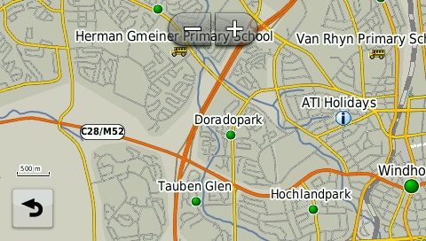
30m Zoom Level
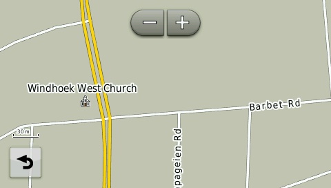
The newer Nuvi units were purposely engineered to limit the amount of POIs that display on the screen to avoid cluttering. Therefore you won’t be able to see all POIs at 80m zoom level. To view POIs (Points of interest) on your GPS, either search for the point under ‘Where To’ (on the main menu) or make a waypoint on the GPS or transfer a waypoint from MapSource / BaseCamp in order to have the POI displayed on the map when viewing.
4) GPS MAPS: “A REFERRAL WAS RETURNED FROM THE SERVER” INSTALLATION ERROR WHEN TRYING TO INSTALL T4A GPS MAPS EXE FILE.
When attempting to install applications in any Microsoft Windows version, some users may experience an error that says “A referral was returned from the server”.
This is generally due to an incorrect system setting.
You can find detailed instructions on the internet to bypass this error. We suggest you google for a solution for your particular Windows version eg. "a referral was returned from the server Windows 10".
A Windows 10 Fix is typically: To solve this problem, try these steps.
Fix 1 - Registry Setting:
Download and run referralfix.zip and run referralfix.reg to automatically apply these changes to your computer.
- Hold the Windows Key and press “R“.
- Type “regedit“, then press “Enter” to bring up the Registry Editor.
- Navigate to HKEY_LOCAL_MACHINE \ SOFTWARE \ Microsoft \Windows \ CurrentVersion \ Policies \ System.
- Open “ValidateAdminCodeSignatures” and set “Value data” to “0“
- Open “EnableUIADesktopToggle” and set the “Value data” to “0“.
Fix 2 – Group Policy
- Hold the Windows Key and press “R“.
- Type “gpedit.msc“, then press “Enter” to bring up the Local Group Policy Editor.
- Expand “Computer Configuration” > “Windows Settings” > “Security Settings” > “Local Policies” > “Security Options“.
- Change the “User Account Control: Only elevate executable that are signed and validated.” policy to “Disabled“.
5) GPS MAPS: I AM UNABLE TO LOCATE ANY POIS ON T4A WITH MY GPS.
The GPS will only search for POIs (Points of Interest) within a certain radius (typically 1 000km) of your current location and won’t pick up any POIs outside of the radius. The way around this is to:- Ensure that the T4A maps are the only maps switched on.
- Set the GPS into Demo mode / Simulation mode. (under Settings > Navigation).
- Then set New Location to a point closer to the area you want to search for POI’s. Select a New Location by pointing the arrow to a position on the map and select Enter. You will then be able to search for POI’s within the radius of the new location that you have just entered.
6) GPS MAPS: I HAVE A GARMIN 76CX, 276, 60CSX AND I’M HAVING DIFFICULTIES LOOKING UP A STREET ADDRESS ON MY GARMAP MAPS WHEN THE TRACKS4AFRICA MAPS ARE ALSO ON MY DEVICE. HOW CAN I SOLVE THIS PROBLEM?
To solve this problem you must have your Street maps and T4A maps on two separate memories. You can have the one on the GPS internal memory and the other one on a separate SD card.
REMEMBER! Each time a map set is sent to a Garmin GPS the previously loaded maps are erased from the GPS. If your Garmap maps are on your SD card, send your T4A maps to the internal memory on your device and vice versa.
7) GPS MAPS: IS IT POSSIBLE TO HAVE BOTH THE TRACKS4AFRICA MAPS AND THE STREET MAPS LOADED ON MY GARMIN GPS UNIT?
Yes, you can have both map sets on your Garmin GPS device, but you may not have them both switched on at the same time.
Please note that some of the Garmin GPS units have the Street maps pre-loaded on the internal memory of the GPS unit which in some cases can’t be overwritten by sending a new map to the internal memory.
If your Street maps aren’t pre-loaded on your GPS and you wish to have both the Tracks4Africa maps and the Street maps on your GPS, then you’ll need to transfer both these mapsets simultaneously to your Garmin GPS unit.
If you don’t have the Street maps loaded on your PC to transfer to your GPS (using Garmin MapSource or Garmin MapInstall) you can transfer our Tracks4Africa maps to a separate SD Card. This will then provide you with the option to have both maps sets available simultaneously on your Garmin GPS unit, which will enable you to switch between the two map sets.
Please note that you can only have one map set selected at a time otherwise your GPS device will give navigational problems.
NB! If you bought a SD Card from one of our retailers, then please ensure that your SD Card is registered on our website. We will then have your details on our records and provide you with your upgrade if eligible as well as discounts on our online shop.
8) GPS MAPS: WHAT IS GARMIN MAPSOURCE AND WHY DO I NEED IT?
Garmin MapSource is a FREE application which enables you to view Garmin compatible maps on your Windows PC, do route planning and transfer maps, waypoints, tracks and routes between your PC and your Garmin GPS device.
MapSource is very similar to BaseCamp, although many people prefer it as it's easier to use. However, MapSource will eventually be phased out.
NOTE: You must have Garmin BaseCamp / MapInstall, installed on your PC before you can install Garmin MapSource.
9) GPS MAPS: WHAT IS GARMIN BASECAMP AND MAPINSTALL AND WHY DO I NEED IT?
Garmin BaseCamp is an application which enables you to view Garmin compatible maps on your Windows PC and Macintosh, do route planning and transfer waypoints, tracks and routes between your PC/Mac and your Garmin GPS device. This is a FREE application from Garmin and it will eventually replace MapSource.
Click here for the link to install BaseCamp for Windows
Garmin MapInstall is also a FREE application which enables you to transfer Garmin compatible maps on your Windows PC and Macintosh to your Garmin GPS unit. Note that MapInstall is a feature incorporated within Garmin BaseCamp too.
10) GPS MAPS: IS IT POSSIBLE TO SEARCH FOR STREET NAMES ON MY TRACKS4AFRICA MAP?
T4A maps are not street maps; however, you can search for streets that are labelled. Most of the streets in South Africa are included.
Street names that are labelled on our maps are searchable but you won’t be able to search for a specific street number.
All Suburbs in South Africa are searchable.