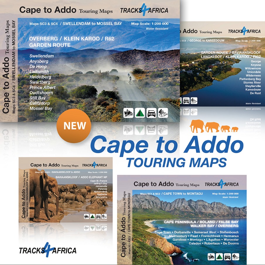
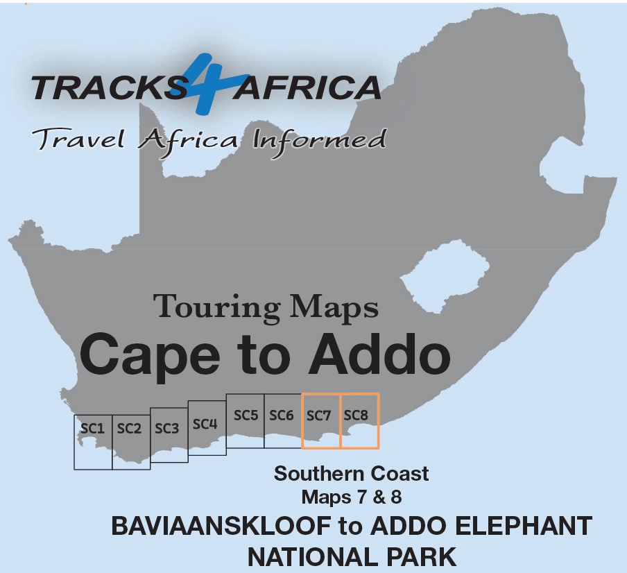
Description
The Cape to Addo map series bundle covers the southern parts of the Western Cape of South Africa in a series of eight highly detailed maps, printed on four sheets of A1 durable paper.
We start in Cape Town in the west and move along the southern coast through the Overberg, Winelands, Garden Route, Klein Karoo R62, Baviaanskloof to eventually arrive in the Addo National Park up to Gqeberha (Port Elizabeth) in the east.
The Cape to Addo Map Series Bundle maps are perfect for day drives, overlanding or just doing road trips in your sedan, 4WD or motorbike along our beautiful southern coast, Klein Karoo and parts of the proper Karoo. Mountain passes form a prominent feature in this area, and these are indicated together with scenic route options.
Adventure bikers will be pleased to know that minor gravel roads are included together with various accommodation options.
The map has a relief background onto which farm boundaries, protected areas and other geographical features are shown.
Over 10 years, the Tracks4Africa community recorded and verified every road by GPS. As a result, the SC7 & SC8 : Baviaanskloof to Addo maps accurately shows roads, landmarks, distances, and travel times.
In fact, the T4A paper map series is likely the world’s first comprehensive country map to offer travel time information. This is true for the entire road network, whether on tar, gravel, or sand!
Key features:
- The maps are highly detailed and well researched
- Our map scale is 1:200 000 which allows us to show a lot of detail including minor gravel roads, hiking trails, farm boundaries and points of interest which are relevant to self-drive tourists.
- The compact size makes it ideal for road trips.
- We use durable Duraflex paper and print two maps per A1 sheet, creating a four-sheet series. Additionally, each map comes in its own protective plastic sleeve.
- Mountain passes are highlight.
- Like other Tracks4Africa maps, these show both drive times and distances. Adventure bikers will value the detailed gravel roads and listed accommodation options.
- The map has a relief background onto which farm boundaries, protected areas and other geographical features are shown.
- For each town, we indicate basic services like fuel, shops, and camping. Additionally, we highlight facilities and activities available at various nature reserves.
- What you see on the SC7 & SC8 : Baviaanskloof to Addo maps are exactly what you get on T4A GPS Maps
- The Cape to Addo Map Series Bundle maps are specifically designed to meet the needs of self-drive travellers, offering clear navigation, detailed routes, and essential travel information for independent exploration.
- Visit www.tracks4africa.com for detail on places of interest
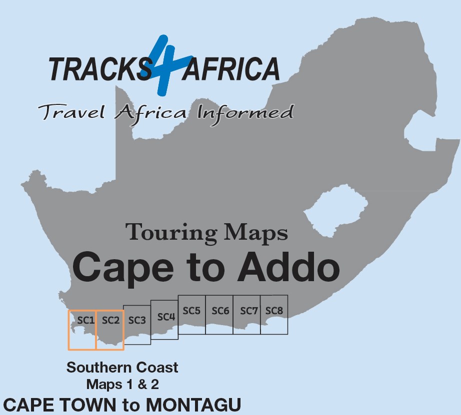
SC1 & SC2 : Cape Town to Montagu
Durable and Practical Design
We print these two maps on durable Duraflex paper, ensuring long-lasting use. Starting in Cape Town, they extend east to Montagu. Along the way, they highlight key coastal and northern towns, including Malmesbury and Worcester.
Map Coverage: Cape Town to Montagu
The SC1 & SC2 map (ie. “SC” stands for “Southern Cape”) — from Cape Town to Montagu—perfectly supports day trips around Cape Town. It includes the Winelands towns of Stellenbosch, Paarl, and Franschhoek.
The The SC1 & SC2 : Cape Town to Montagu maps highlight iconic Western Cape attractions like Cape Point, Table Mountain, and Robben Island. They also cover Cape wine routes, Hermanus whale watching, Africa’s southern tip at L’Agulhas, and shark cage diving at Gansbaai.
Plan with Confidence
With driving times and scenic routes clearly marked, including Western Cape mountain passes, you can easily plan your trips. Furthermore, this area offers top-tier destinations featuring world-class restaurants and wine estates.
SC3 & SC4 : Swellendam to Mossel Bay Map
Durable and Practical Design
We print the SC3 & SC4: Swellendam to Mossel Bay maps on durable Duraflex paper for lasting use. Starting in Swellendam, they extend through Mossel Bay to Oudtshoorn, following the southern coastline and reaching north to Anysberg Reserve, the N1, and Prince Albert.
Map Coverage: Swellendam to Mossel Bay
The SC3 & SC4: Swellendam to Mossel Bay maps showcase a road-tripper’s dream route. First, set out by bike, 4WD, camper van, or car. Then, explore a diverse region that delivers unforgettable experiences for every traveller.
Experience the Charm of the Klein Karoo
Beyond Montagu on the R62, the relaxed Klein Karoo vibe takes over. Along the way, towns welcome you with coffee shops, farm stalls, restaurants, and curio stores—all competing for your attention.
Accommodation for Every Traveller
The SC3 & SC4 : Swellendam to Mossel Bay map features a wide range of accommodation options to suit every budget. This makes it easy to plan overnight stops along your journey.
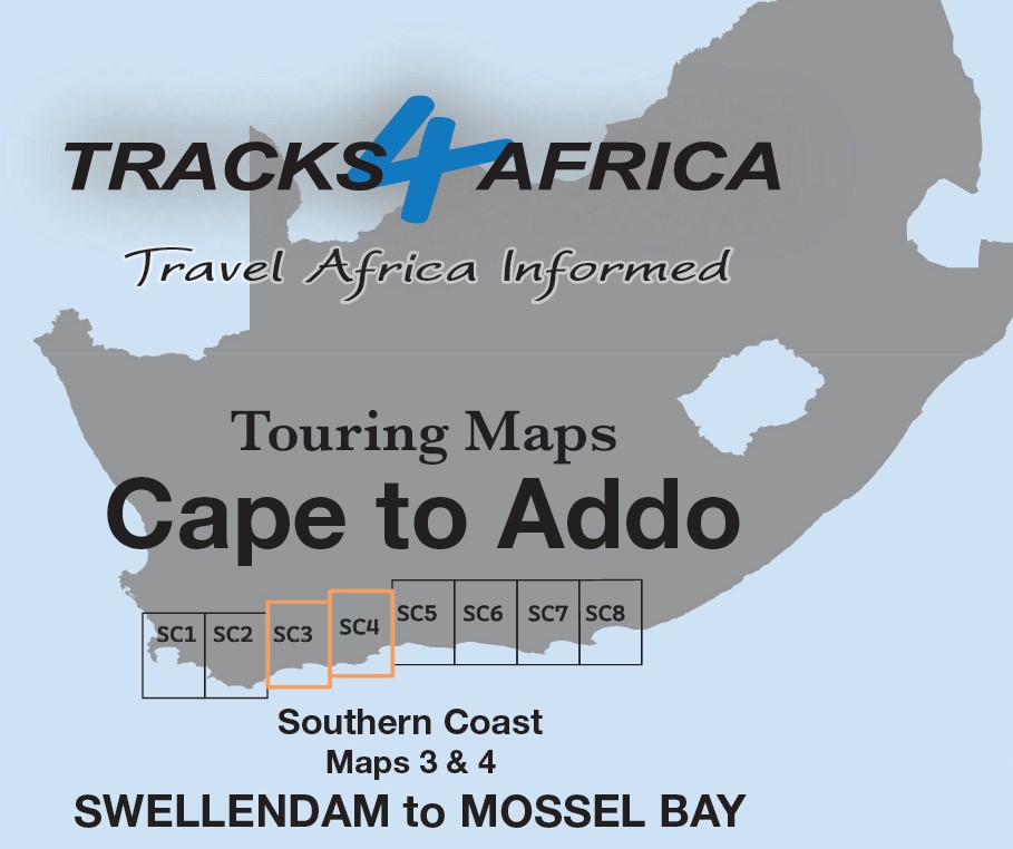
Rejuvenate Your Soul
With scenic back roads and a tranquil atmosphere, this region invites you to slow down and explore. Along the way, you can reconnect both with the road and yourself.
SC5 & SC6 : George to Kareedouw Map
The SC5 & SC6 : George to Kareedouw maps are the third 2 mapsets in this series.
Highlights, Landscapes, and Adventures
The SC5 & SC6: George to Kareedouw maps span from George to Kareedouw, bordered by the southern coast and northern Karoo towns. First, explore the famous Garden Route, then discover hidden gems like Langkloof Valley and the rugged Baviaanskloof wilderness, which appeal to hikers, bikers, and 4WD adventurers.
Diverse Landscapes and Scenic Highlights
The landscape on the SC5 & SC6 : George to Kareedouw map ranges from lush forests and deep valleys to dramatic mountain passes and warm Indian Ocean beaches. Between George and Plettenberg Bay, the coastline offers some of South Africa’s most stunning, swim-friendly beaches.
Along the Garden Route, green forests stretch between George and Storms River Mouth; meanwhile, the historic Seven Passes Road, built by Thomas Bain, invites exploration, and the iconic Otter Trail offers a renowned multi-day coastal hike from Storms River Mouth to Nature’s Valley.
Adventure and Activities
Tourists can explore the famous Knysna Lagoon and Heads by boat or thrill-seek with the world’s highest bridge bungy jump at Bloukrans Bridge near Nature’s Valley.
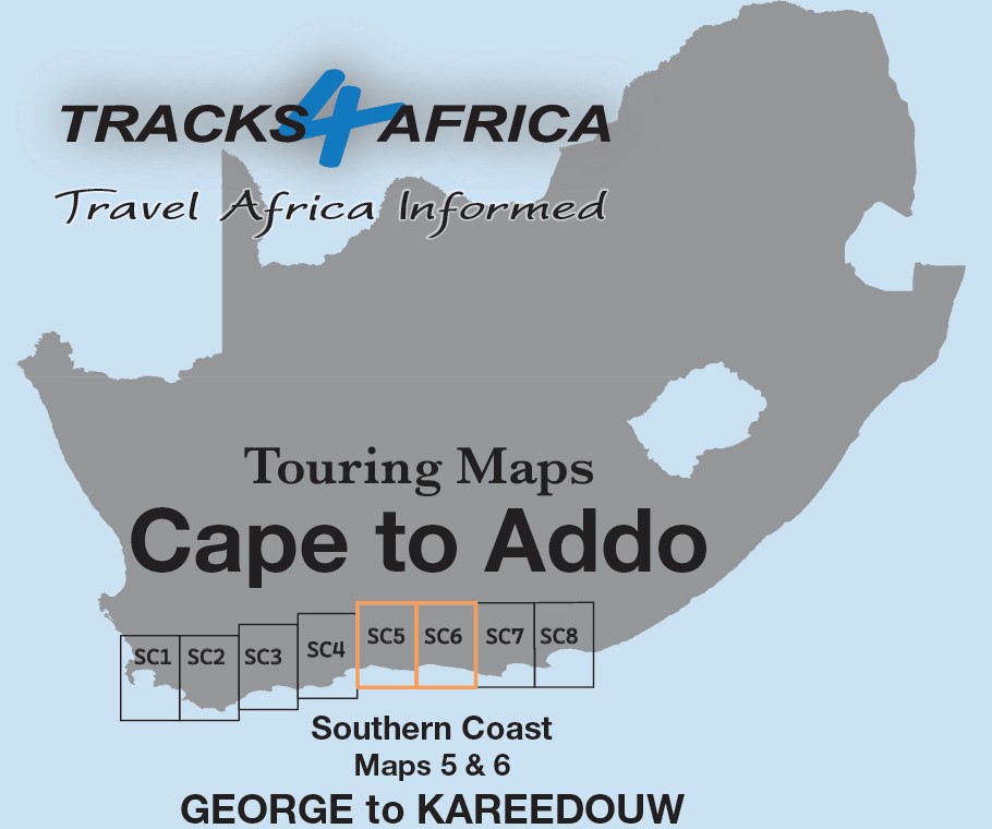
Rejuvenate Your Soul
For camping, pitch a tent at Ebb & Flow in Wilderness or right on the ocean’s edge at Storms River Mouth.
SC7 & SC8 : Baviaanskloof to Addo Map
The SC7 & SC8 : Baviaanskloof to Addo maps are the fourth 2 mapsets in this series.
Ideal for All Types of Road Trips
The SC7 & SC8 : Baviaanskloof to Addo maps are ideal for day drives, overlanding, or road trips by sedan, 4WD, or motorbike. They guide you along the scenic southern coast, through the Klein Karoo, and into the greater Karoo.
Explore the Eastern Cape: Addo, Baviaanskloof & the Garden Route
The Addo Elephant National Park takes center stage on these two maps. From there, explore the eastern Baviaanskloof, and then follow the Garden Route along the coast from Cape St. Francis to Gqeberha (Port Elizabeth).
From Coastline to Inland Towns
The SC7 & SC8: Baviaanskloof to Addo maps print on both sides of a single Duraflex sheet. They stretch from Cape St. Francis in the west to Alexandria in the east, following the southern coastline and reaching north to include towns like Jansenville and Middleton.
Get the full set!


 Tracks4Africa
Herman van der Linden (verified owner) –
We recently purchased the Cape to Addo Map Series Bundle along with the A3 Traveller’s Atlas Southern Africa (Edition 2), and we couldn’t be more pleased. The layout is absolutely beautiful, and the level of detail is meticulous—clearly crafted with care and expertise.
The additional information included throughout both products adds real value, making them not just maps but comprehensive travel companions. The high-quality print and durable sleeve ensure they’ll stand up to frequent use, whether on the road or in planning sessions.
These maps are a joy to use and will be central to our upcoming road trips and holidays. Thank you, Tracks4Africa, for producing such outstanding resources!
Christopher john Hayman (verified owner) –
The perfect companion for touring the cape – well done
Craig Naude (verified owner) –
What a wonderful way to plan a trip. Much easier – just spread them out and look at all the amazing route options. Way to go from Cape to Addo!
Ken Vaughan (verified owner) –
I have found these maps very detailed and useful. They seem to be on reasonably tough paper so should last a long time.
Peer Iuel (verified owner) –
As usual a great product, most useful!
Tom Plaistowe (verified owner) –
Bought for my wife who loves paper maps. Success
Timothy Pentz (verified owner) –
Great maps. They have opened up new adventures for me.
Wolfgang Breidert (verified owner) –
I’ve checked them, as I love the router and have so far not found anything missing or wrong. We are going early February again so then I will use them extensively. Great work Hopefully other regions will follow (eg. Cape Town to the Kalaghadi etc.)