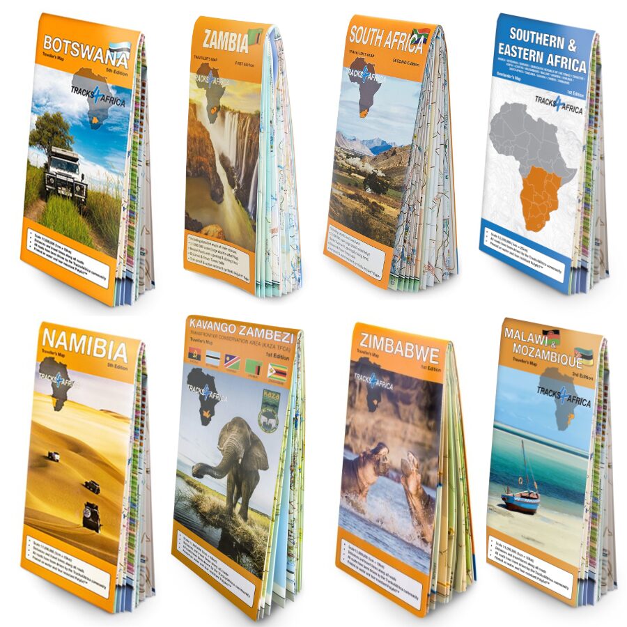
Description
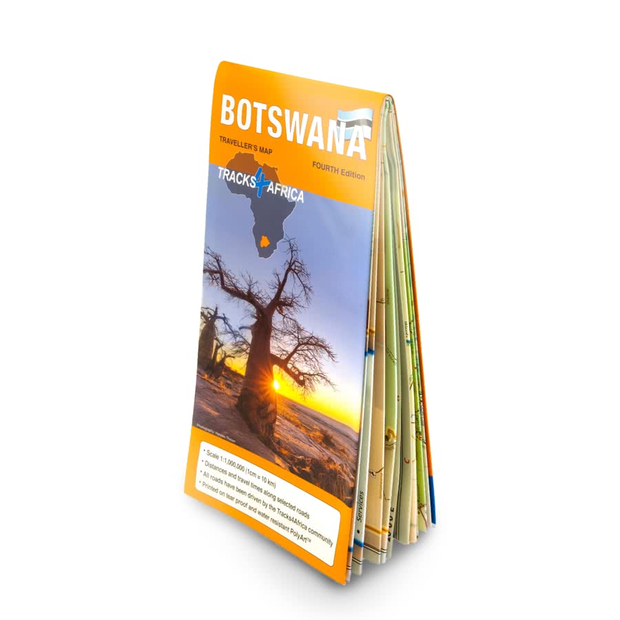
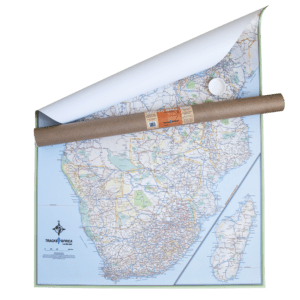
Botswana Traveller’s Paper Map
You can use the Botswana Traveller’s Paper Map 5th Edition alongside the T4A GPS Map. As the largest Botswana paper map at 1:1,000,000 scale, it consequently helps you plan your trip perfectly and reveals key insights into Botswana’s geography and travel logistics.
KEY FEATURES:
- Printed on tear proof and water resistant Polyart
- Scale 1:1,000,000 (1cm = 10km)
- When unfolded this map is 1000x1265mm.
- The Tracks4Africa Community has driven all roads.
- Map key included
- Map index included
- Detailed vector maps of the Okavango Delta, Mabuasehube, Savuti, Gaborone, Maun, Kasane, Khwai East and West
- The guide covers border red tape, camping etiquette, driving tips, fuel, and key contacts. Additionally, it prepares you for a smooth, hassle-free trip
- The Botswana paper map indicates distances and travel times between towns
- Main services indicated with icons in main towns
- Border Controls with opening and closing times
- In addition, there are detailed maps eg. Gaborone
The map’s routes and details are based on over 10 years of GPS-verified data. Moreover, the Tracks4Africa travel community collected and confirmed this data, ensuring accuracy.
All map locations are included in the T4A GPS Maps; thus, no manual coordinate transfer is needed. Furthermore, the GPS maps offer full coverage of Botswana’s tourist spots and, as a result, guide you to every featured destination.
Kavango Zambezi Transfrontier Conservation Area (KAZA) Paper Map
One map that does it all! If you plan to travel to a collection of the most popular overland destinations in Southern Africa, then you have to consider the Kavango Zambezi Transfrontier Conservation Area Map (KAZA) paper map 1st Edition. Notably, the KAZA paper map refers to the world’s largest transfrontier land-based conservation area.

Coverage
The KAZA region spans five Southern African countries—Angola, Botswana, Namibia, Zambia, and Zimbabwe. It covers over 519,000 sq km (200,387 sq miles). Moreover, it boasts three UNESCO World Heritage Sites and offers a rich collection of natural and cultural wonders. These features make it a must-visit destination for adventurous travellers.
Key features:
- Scale 1:1,000,000(1cm = 10km)
- Distances and travel times along all roads
- All roads have been driven by the Tracks4Africa community
- Printed on water and tear resistant PolyArt
Whether you’re aiming to spot the Big 5, add 600 bird species to your life list, or simply relax under an African sunset in a Mokoro, KAZA paper map delivers it all. Moreover, it combines thrilling wildlife encounters with unforgettable moments of peace, making every journey truly rewarding.
Highlights
The Kavango Zambezi Transfrontier Conservation Map (KAZA) showcases Southern Africa’s widest range of safari experiences. It highlights must-see destinations such as Mosi-oa-Tunya Falls (Victoria Falls), the Okavango Delta, and Tsodilo Hills—these are all UNESCO World Heritage Sites.
Moreover, the 1st Edition KAZA Paper Map spans from Kafue National Park in the north to Makgadikgadi in the south. Additionally, it stretches from Windhoek in the west to Kariba in the east. This makes it an essential guide to the region’s top self-drive destinations.
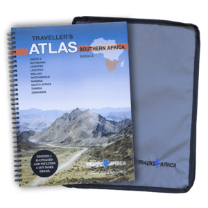
Malawi & Mozambique Traveller’s Paper Map
Now in its 3rd edition, the Malawi & Mozambique Traveller’s Paper Map works seamlessly with the T4A GPS Map of the same region. Furthermore, with a 1:1,000,000 scale, it offers the largest and most detailed coverage of both countries. Therefore, it serves as an ideal tool for planning your next Mozambican or Malawian adventure.
For over 10 years, Tracks4Africa travellers have actively recorded and GPS-verified every road, ensuring unmatched accuracy. As a result, the roads, tracks, places of interest, distance data, and travel time estimates on the map accurately reflect their collective travel experience.
You don’t need to transfer GPS coordinates manually because our T4A GPS Maps already include everything on the paper map. Plus, they offer comprehensive coverage of tourist destinations in Mozambique and Malawi, allowing you to navigate easily to every location shown.
Key features:
- The map is printed on tear-proof and water-resistant Polyart, ensuring durability during your travels.
- Scale 1:1,000,000 (1cm = 10km)
- Importantly, members of the Tracks4Africa community have personally driven every road, which ensures accurate and firsthand mapping.
- Map key included
- Map index included
- Furthermore, the map clearly indicates distances and travel times between towns. It helps you plan your journey more efficiently.
- Main services indicated with icons in main towns
- Border Controls with opening and closing times
- Additionally, the map includes the locations of campsites, lodges, attractions, and other key points of interest. This enhances your travel experience.
When unfolded the Malawi & Mozambique Traveller’s Paper Map is 1000×1265 mm (11 folds).
The T4A paper map series likely represents the world’s first comprehensive country maps to offer travel time information across the entire road network. In fact, it covers all surfaces—whether tar, gravel, or sand—making it uniquely reliable for trip planning.
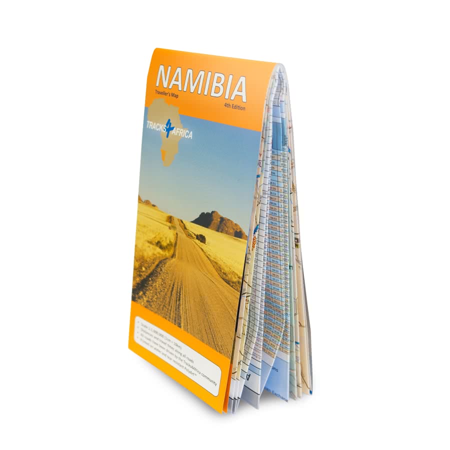
Namibia Traveller’s Paper Map
The Namibia Traveller’s Paper Map 5th Edition, works seamlessly with the T4A GPS Map of Namibia. In addition, its 1:1,000,000 scale makes it the largest available map of the country, offering the perfect tool for planning your next Namibian holiday.
What you see on the Namibia paper map is exactly what you get on T4A GPS Maps.
The T4A GPS Maps include all locations featured on the Namibia Traveller’s Paper Map, 5th Edition, so you don’t need to transfer coordinates manually. Additionally, the GPS maps offer comprehensive coverage of Namibia’s tourist destinations and guide you directly to every place shown.
Visit www.tracks4africa.com for detail on places of interest.
Key features:
- Printed on tear proof and water resistant Polyart
- Scale 1:1,000,000 (1cm = 10km)
- When unfolded this map is 1000x1265mm.
- Tracks4Africa community members have personally driven all roads, ensuring accurate and reliable mapping.
- Comprehensive set of roads and tracks in nature reserves
- Kaokoland in great detail with commonly used tracks
- Detailed maps for Swakopmund and Windhoek
- Map key included
- Map index included
- Additionally, shaded relief highlights mountains and other topographical features, enhancing map readability and terrain awareness.
- Travel information like border post red tape, camping etiquette, driving in Botswana, fuel, useful contact numbers etc.
- The map clearly shows distances and travel times between towns.
- Main services indicated with icons in main towns
- Furthermore, the map displays border controls along with their opening and closing times, helping you plan your route more effectively.
Over the past 10 years, the Tracks4Africa community has collectively recorded and verified every road using GPS. As a result, the roads, tracks, places of interest, distance data, and travel time estimates on the Namibia Traveller’s Paper Map, 5th Edition, accurately reflect their real-world travel experience.
In fact, the T4A paper map series is likely the world’s first comprehensive country map to offer travel time information for the entire road network, whether on tar, gravel, or sand!
South Africa Traveller’s Paper Map
The South Africa Paper Map 2nd Edition belongs to the T4A paper map series, which likely represents the world’s first comprehensive country maps. Moreover, these maps offer travel time information across the entire road network, whether on tar, gravel, or sand!
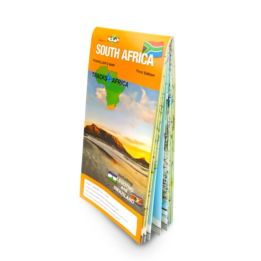
Tracks4Africa builds its maps specifically for self-drive travellers, packing them with essential information to help you plan your next adventure. Additionally, the Tracks4Africa South Africa paper map pairs seamlessly with the T4A GPS Map of South Africa.
The South Africa paper map also includes Lesotho and Swaziland. The map scale is 1:1 000 000 which gives you enough detail but also allows for an overview of the country. The map is printed on PolyArt which is tear and water resistant and will survive your adventures with you.
Key Features:
- Printed on tear proof and water resistant Polyart
- Scale 1:1,000,000 (1cm = 10km)
- When unfolded this South Africa Paper map is 1000x1380mm.
- Large 1:1,000,000 scale (large double-sided map)
- Travel times and distances shown on roads
- This large paper map prints on both sides and folds down to an easy-to-use size. Additionally, it comes packed in a plastic sleeve for extra protection.
- What you see on the South Africa Paper Map 2nd Edition is exactly what you get on T4A GPS Maps
- Comprehensive set of roads and tracks in nature reserves
- The South Africa Paper Map is specifically designed to meet the needs of self-drive travellers.
- Border crossings indicated with opening and closing times
- Visit www.tracks4africa.com for detail on places of interest
- Shaded relief background
- Includes the Kgalagadi
You don’t need to transfer GPS coordinates manually because the South Africa Paper Map 2nd Edition includes everything found in our T4A GPS Maps. Therefore, you can use the T4A GPS Maps to navigate directly to every destination shown on the map.
The roads, tracks, places of interest as well as the distance data and travel time estimates on the South Africa Paper Map reflect the collective travel experience of the Tracks4Africa community of travellers over the past 10 years, with every single road being GPS recorded and verified by this community.
Zambia Traveller’s Paper Map
Tracks4Africa builds its maps specifically for self-drive travellers, packing them with information to help you plan your next adventure. Additionally, the Zambia Traveller’s Paper Map 1st Edition pairs seamlessly with the T4A GPS Map of Zambia.

You don’t need to transfer GPS coordinates manually because our T4A GPS Maps already include everything shown on the paper map. Therefore, you can use the T4A GPS Maps to navigate directly to every destination featured.
The map scale is 1:1 000 000. This gives you enough detail but also allows for an overview of the country.
Discover Zambia: The Most Up-to-Date Tracks4Africa Paper Map for Self-Drive Travellers
Tracks4Africa CEO, Johann Groenewald, has spent the last nine years exploring all corners of this evergreen country. He fell in love with its unspoilt beauty.
After years of updating our GPS maps and sending research teams to verify minor roads and park tracks, Tracks4Africa has finally published its Zambia paper map. At a 1:1 million scale, it now stands as the most up-to-date printed map available for self-drive travellers.
Key features:
- Large 1:1,000,000 scale (large double-sided map)
Travel times and distances shown on roads - Large paper map, printed on both sides. It folds down to an easy-to-use size. Packed in a plastic sleeve for extra protection.
- When unfolded this map is 1000x1265mm.
- What you see on the paper map is exactly what you get on T4A GPS Maps
- Comprehensive set of roads and tracks in nature reserves
- Map designed to suit the needs of self-drive travellers
- Border crossings indicated with opening and closing times
- Visit www.tracks4africa.com for detail on places of interest
- We print the map on durable PolyArt material. This material is tear and water resistant. Therefore, it will survive your adventures with you.
- Shaded relief background
Over the past 10 years, the Tracks4Africa community has collectively recorded and verified every road using GPS. As a result, the roads, tracks, places of interest, distance data, and travel time estimates on the Zambia Traveller’s Paper Map 1st Edition, accurately reflect their real-world travel experience.
In fact, the T4A paper map series is likely the world’s first comprehensive country map to offer travel time information. This is true for the entire road network, whether on tar, gravel, or sand!
In addition to this, the Tracks4Africa research team has also driven every major road. They visited every single park in the country to verify details.
Zimbabwe Traveller’s Paper Map
Zimbabwe has long been the overlanding jewel of Southern Africa, and we’re excited to finally offer a dedicated paper map. Now, with the high-detail Zimbabwe Traveller’s Paper Map 1st Edition, you can plan your trip easily using marked points of interest, national parks, service towns, and connecting roads. Like our other maps, it includes time and distance indicators for efficient route planning.

You don’t need to transfer GPS coordinates manually because our T4A GPS Maps already include everything shown on the paper map. Therefore, you can use the T4A GPS Maps to navigate directly to every destination featured.
The map scale is 1:1 000 000. This gives you enough detail but also allows for an overview of the country.
Key features:
- Large 1:1,000,000 scale (large double-sided map)
Travel times and distances shown on roads - Large paper map, printed on both sides. It folds down to an easy-to-use size. Packed in a plastic sleeve for extra protection.
- When unfolded this Zimbabwe paper map is 1000x1265mm.
- What you see on the paper map is exactly what you get on T4A GPS Maps
- Comprehensive set of roads and tracks in nature reserves
- Map designed to suit the needs of self-drive travellers
- Border crossings indicated with opening and closing times
- Visit www.tracks4africa.com for detail on places of interest
- We print the map on durable PolyArt material. This material is tear and water resistant. Therefore, it will survive your adventures with you.
- Shaded relief background
Over the past 10 years, the Tracks4Africa community has collectively recorded and verified every road using GPS. As a result, the roads, tracks, places of interest, distance data, and travel time estimates on the Zimbabwe Traveller’s Paper Map 1st Edition, accurately reflect their real-world travel experience.
In fact, the T4A paper map series is likely the world’s first comprehensive country map to offer travel time information. This is true for the entire road network, whether on tar, gravel, or sand!
In addition to this, the Tracks4Africa research team has also driven every major road. They visited every single park in the country to verify details.
Southern & Eastern Africa Paper Map
TRACKSAFRICA OVERLANDER MAP – THE SOUTHERN & EASTERN AFRICA PAPER MAP EDITION 1 IS FOR DREAMERS, ADVENTURE SEEKERS, AND THOSE WHO YEARN TO EXPERIENCE AFRICA’S RUGGED WILDERNESS BY VEHICLE.
With over 25 years of mapping and overland travel experience, we bring you a map designed from an overlander’s perspective of Southern and Eastern Africa. Although it also covers parts of Central Africa, most key routes and destinations focus on the Southern and Eastern regions.

Note: the Southern & Eastern Africa Paper Map does NOT include travel times and distances like our country maps.
Over the past 10 years, the Tracks4Africa community has actively recorded and GPS-verified every road. As a result, the roads, tracks, and points of interest on the Southern & Eastern Africa Paper Map Edition 1 accurately reflect real-world travel experience.
Key features:
- The S&E Africa paper map covers: Angola, Botswana, Burundi, DRC, Eswatini, Kenya, Lesotho, Mozambique, Malawi, Namibia, Rwanda, South Africa, Tanzania, Uganda, Zambia, Zimbabwe.
- Large 1:2.5 million scale (ideal for macro planning extended trips or tracking your adventures)
- This large paper map prints on both sides and folds down to a convenient, easy-to-use size. It also comes in a plastic sleeve for added protection.
- When unfolded the Southern & Eastern Africa Paper Map Edition 1 is 1000 x 1380 mm.
- What you see on the S&E Africa Paper Map matches exactly what you get on the T4A GPS Maps, ensuring seamless navigation between paper and GPS.
- Major Tourist Attractions: Discover iconic landmarks and must-see destinations.
- Map designed to suit the needs of self-drive travellers
- National Parks and Game Reserves: Explore Africa’s renowned wildlife sanctuaries.
- Visit www.tracks4africa.com for detail on places of interest
- We print the S&E paper map on durable PolyArt material. This material is tear and water resistant. Therefore, it will survive your adventures with you.
- Road Network: Navigate with confidence using our detailed road classifications, from highways to 4WD tracks.
- International Airports and Border Posts: Plan your entry and exit points with ease.
- Relief Shading: Visualize the landscape with textured terrain.


 Tracks4Africa
Reviews
There are no reviews yet.